MyTopo
Historic 1892 Whitesburg Kentucky 30'x30' Topo Map
Couldn't load pickup availability
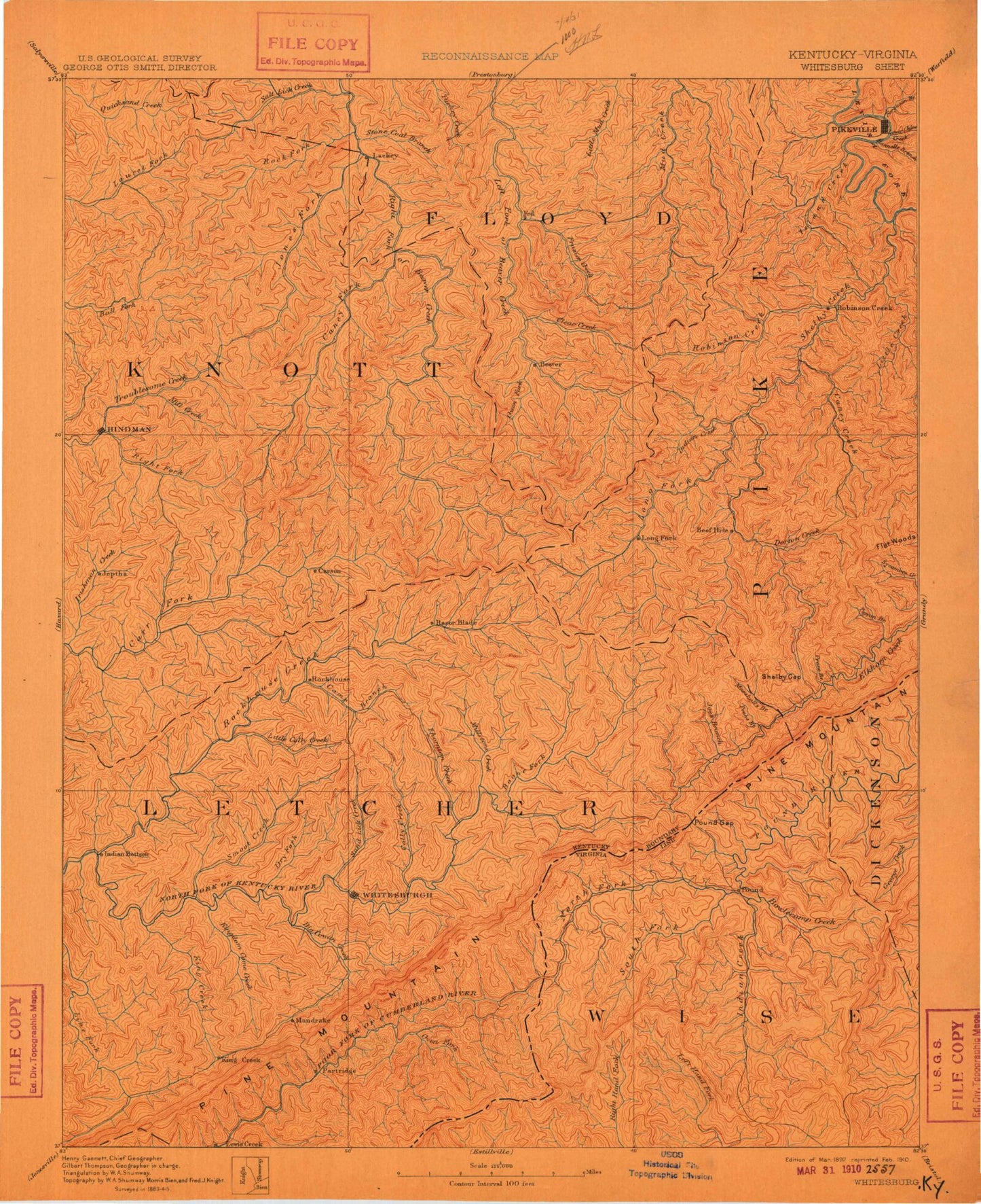
Historical USGS topographic map of Whitesburg in the state of Kentucky. Scale: 1:125000. Print size: 17" x 24"
This map was published in 1892 and is in the following counties: -.
The map contains contour lines, roads, rivers, towns, streams, and lakes. Printed on high-quality waterproof paper with UV fade-resistant inks.
Contains the following named places: Colliers Creek, South Fork Collier Creek, Abe Fork, Abel Tackett Fork, Abner Branch, Abner Fork, Abner Mountain, Adams Branch, Adams Branch, Aker Branch, Akers Branch, Allen Branch, Alum Cave Branch, Alum Cave Branch, Amburgey Branch, Anderson Branch, Andy Branch, Andy Branch, Appletree Branch, Arnold Fork, Arnold Fork, Austin Gap, Bad Branch, Bailey Branch, Baker Hollow, Ball Branch, Barkcamp Branch, Barlow Branch, Barn Ridge, Bartesta Branch, Bates Branch, Bear Branch, Bear Branch, Bear Fork, Bear Fork, Beaver, Beaver Fork, Beaver Gap, Beaverdam Branch, Bee Branch, Beechnut Fork, Beefhide Creek, Beetree Branch, Beetree Hollow, Bellcraft, Bens Branch, Bentley Hollow, Big Bend Branch, Big Bottom Branch, Big Branch, Big Branch, Big Branch, Big Branch, Big Branch, Big Branch, Big Branch, Big Doubles Branch, Big Eli Branch, Big Firecoal Branch, Big Hill, Big Hollow, Big John Hollow, Big Lick Gap, Big Shelby Branch, Big Springs Branch, Biglick Branch, Bill D Branch, Bill Harris Branch, Bill Moore Branch, Black John Branch, Blackburn Branch, Blair Branch, Blair Branch, Blair Branch, Blaze Branch, Bloomer Branch, Blue Branch, Bo Fork, Bob Gap, Bobs Branch, Bolen Branch, Booker Branch, Booker Fork, Booker Hollow, Boone Fork, Boone Gap, Bosco, Bottom Fork, Bottom Fork, Box Fork, Bradley Branch, Branham Branch, Branham Creek, Branhams Branch, Bratten Hollow, Breeding Branch, Breeding Creek, Brown Branch, Brown Branch, Bruce Branch, Brushy Fork, Brushy Fork, Bryant Branch, Bryant Gap, Buck Branch, Buck Branch, Buck Creek, Buck Tackett Branch, Buckeye Branch, Buckhorn Branch, Buckhorn Fork, Buckhorn Hollow, Bucklick Fork, Bucks Branch, Buffalo Branch, Bunker Branch, Burdine, Burk Branch, Burton, Bush Branch, Buzzer Branch, Cabin Fork, Cager Branch, Caleb Fork, Calfpen Branch, Calhoun Branch, Camp Branch, Camp Branch, Camp Fork, Cane Branch, Cane Branch, Cane Branch, Cane Fork, Cane Fork, Cane Hollow, Caney Creek, Caney Fork, Cantrell Gap, Carr Creek, Carr Fork Lake, Carrion Branch, Caudill Creek, Cave Branch, Cedar Creek, Chestnut Mountain, Chopping Branch, Clay Fork, Clear Creek, Coal Branch, Coal Branch, Coal Branch, Collier Rocks, Collins, Collins Branch, Combs Branch, Combs Branch, Combs Branch, Combs Branch, Company Branch, Compton Branch, Compton Branch, Cook Hollow, Coolwater Branch, Cornetts Branch, Cottonpatch Branch, Cottonpatch Branch, Cow Branch, Cowan Branch, Cowan Creek, Crafts Colly Creek, Crager Fork, Craiger Branch, Cram Creek, Crases Branch, Cromona, Daniels Branch, Day Branch, Dead Mare Branch, Deadening Branch, Deadening Fork, Deadening Fork, Deadman Branch, Deal Branch, Deerlick Branch, Defeated Creek, Defeated Creek, Dick Branch, Dismal Branch, Dog Fork, Dorton, Dorton Creek, Doty Branch, Doty Creek, Douglas, Drift, Dry Branch, Dry Creek, Dry Fork, Dry Fork, Dry Fork, Dunham, Duty Knob, East Jenkins, East McDowell, Edwards Branch, Elisha Fork, Elk Creek, Elk Pond, Elkhorn Lake, Elkins Branch, Ellis Lick, Ellwood, Elswick Branch, Ermine, Esteps Branch, Estill, Fairchild Branch, Ferguson Creek, Fishpond Branch, Fitch Branch, Flat Fork, Flat Rockhouse Branch, Flatwoods, Flaxpatch Branch, Fleming, Fleming Branch, Flintfield Branch, Fords Branch, Fords Branch, Fourmile Branch, Franklin Branch, Franks Creek, Frasure Branch, Frasure Creek, Frazier Branch, Friday Branch