MyTopo
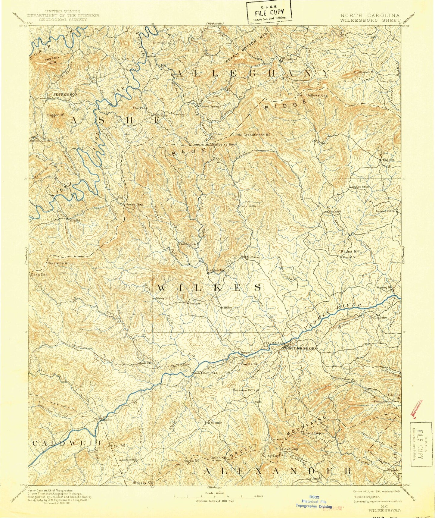
Historic 1891 Wilkesboro North Carolina 30'x30' Topo Map
Couldn't load pickup availability
Historical USGS topographic map of Wilkesboro in the state of North Carolina. Scale: 1:125000. Print size: 17" x 24"
This map was published in 1891 and is in the following counties: Alexander, Alleghany, Ashe, Caldwell, Iredell, Watauga, Wilkes.
The map contains contour lines, roads, rivers, towns, streams, and lakes. Printed on high-quality waterproof paper with UV fade-resistant inks.
Contains the following named places: Air Bellows Gap, Air Bellows Overlook, Alder Gap, Alligator Back, Antioch, Lake Ashe, Bandits Roost Park, Basin Coves Overlook, Basin Creek, Bear Creek, Bear Den Branch, Beaver Branch, Beaver Creek, Beaver Creek, Bee Branch, Bee Tree Branch, Bell Branch, Bell Mountain, Bell Ridge, Benge Gap, Benge Knob, Berry Mountain, Betseys Rock Falls, Big Branch, Big Pine Creek, Big Ridge, Big Sandy Creek, Big Warrior Creek, Blairs Island, Bledsoe Creek, Blood Creek, Blood Creek Overlook, Blue Creek, Bluff Mountain Overlook, Bluff Ridge, Boomer Road Access Area, Boone Gap, Bowlin Creek, Brinegar Cabin, Brooks Branch, Brooks Knob, Brushy Mountains, Bucks Peak, Buckwheat Branch, Bullhead Creek, Bullhead Mountain, Bullhead Mountain Overlook, Bumgarner Branch, Bumgarner Gap, Butte Mountain, Calloway Gap, Camp Albert Butler, Camp Branch, Camp Branch, Camp Cheerio, Camp Creek, Cane Creek, Cascade Falls, Cascade Overlook, Caudill Branch, Caudill Cabin, Cedar Ridge, Cheatwood Branch, Cheek Branch, Cherry Lane, Chestnut Mountain, Chestnut Mountain, Church Branch, Clear Branch, Coal Creek, Cole Branch, Combs Knob, Cook Branch, County Line Ridge, Cove Creek, Cove Gap, Crab Fork, Cranberry Creek, Creasey Branch, Cub Creek, Daniels Gap, Dark Hollow, Darnell Creek, Davis Creek, Davis Mountain, Deep Gap, Dehart, Dehart Branch, Devils Garden, Devils Garden Overlook, Dividing Ridge, Dog Creek, Dogwood Branch, Dogwood Trail, Double Creek, Doughton Recreation Area, Dungeon Creek, East Fork Pine Swamp Creek, East Prong Roaring River, Elk Creek, Elk Shoals Camp, Elkville, Ellis Knoll, Evans Branch, Ezra Fork, Fall Creek, Fire Scale Mountain, Fishing Creek, Flat Rock Knob, Flat Rock Ridge, Fletcher Creek, Fodder Stack, Foster Springs Branch, Fox Branch, Frenches Knob, Gambill Creek, Garden Creek, Garner Mountain, Gill Knob, Gillam Gap, Glade Valley, Gladys Fork, Grandmother Mountain, Greasy Mountain, Greens Ridge, Greenstreets Mountain, Hall Mountain, Halls Creek, Handy Branch, Handy Gap, Handy Mountain, Hanging Valley, Harris Creek, Harrold Mountain, Hay Meadow Creek, Haynes Branch, Hays, Hewed Log Gap, Hoopers Branch, Hoover Mountain, Horse Cove Branch, Horse Gap, Huckleberry Ridge, Huffman Branch, Huffman Mountain, Husons Ridge, Idlewild, Index, Ivy Point Ridge, Jerry Mountain, Johnson Mountain, Jones Creek, Joshua Creek, Joynes, Jumpinoff Rock Overlook, Kilby Branch, Kilby Gap, Kings Creek, Laurel Branch, Laurel Branch, Laurel Fork, Laurel Ridge, Laurel Spur Ridge, Left Prong Stony Fork, Lewis Fork, Lewis Fork Overlook, Little Creek, Little Falls, Little Fork, Little Fork Creek, Little Glade Creek, Little Glade Millpond, Little Kings Creek, Little Mountain, Little Mountain, Little Naked Creek, Little Peak Creek, Little Phoenix Creek, Little Phoenix Mountain, Little Piney Creek, Little Sandy Creek, Little Stone Mountain, Little Warrior Creek, Long Branch, Long Branch, Long Shoals Creek, Lousy Creek, Lovelace Creek, Low Gap, Low Notch, Lowe Mountain, Luther Overlook, Mahogany Rock Overlook, Maple Branch, Maple Springs, Mars Mountain, Martins Low Gap, Meadow Branch, Meadow Branch, Meadow Fork, Middle Fork Reddies River, Middle Prong Roaring River, Mill Creek, Mill Creek, Mill Creek, Miller Gap, Millers Creek, Moore Mountain, Moravian Creek, Moravian Falls, Moravian Falls, Mount Jefferson Overlook, Mount Jefferson State Park, Mount Pleasant, Muddy Branch, Mulberry Creek, Mulberry Gap, Naked Creek, Naked Creek, Nathans Creek, Nathans Creek, Nathens Ridge, Nettle Knob, No Head Branch, Noel Branch, North Fork Reddies River, North Prong Lewis Fork, North Wilkesboro, North Wilkesboro Speedway, Oakwoods, Oakwoods Country Club, Obids Creek, Old Taylor Branch, Osborn Creek, Peach Bottom Mountain, Peak Creek