MyTopo
Historic 1898 Winslow Arkansas 30'x30' Topo Map
Couldn't load pickup availability
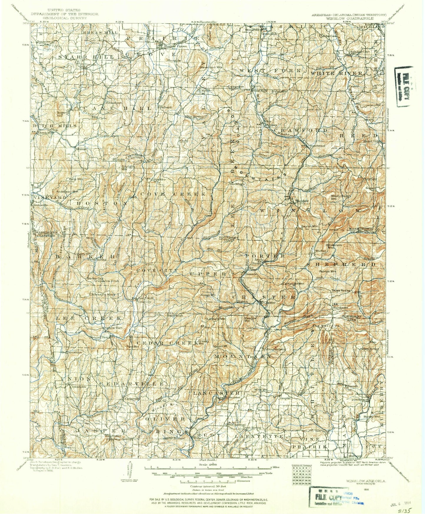
Historical USGS topographic map of Winslow in the state of Arkansas. Scale: 1:125000. Print size: 18" x 24"
This map was published in 1898 and is in the following counties: Adair, Crawford, Franklin, Sequoyah, Washington.
The map contains contour lines, roads, rivers, towns, streams, and lakes. Printed on high-quality waterproof paper with UV fade-resistant inks.
Contains the following named places: Blair Creek, Dye Creek, Fraker Mountain, George West Hollow, Glendale Branch, Hannah Branch, Hickory Creek, Hogeye Creek, John Turner Fork, Jordan Creek, Lutman Hollow, Mill Creek, New Hope Community Hall, Owl Hollow, Parker Branch, Pierce Hollow, Prairie Grove Battlefield State Park, Price Creek, Richardson Hollow, Ridge, Snyder Mountain, Sugar Hill, River Ridge Park, Black Oak, Wyola, Arnett, Hicks, Lingebaugh Mountain, Pinnacle, Stevenson Mountain, Sugar Mountain, Suttle, West Mountain, Cane Hill Mountain, Everett Mountain, Garrett Hollow Creek, Lake Wilson Park, North Mayberry Mountain, Old Male Coal Bank, Parricks Ridge, Round Mountain, South Mayberry Mountain, Sweetwater Creek, Washburn Mountain, White Oak Mountain, Wolf Mountain, Ball, Huey Creek, Maddux Spring, Whizzen Hollow Creek, Township of Black Oak, Township of Miller, Township of Cedar Creek, Township of Cedarville, Township of Chester, Township of Cove City, Township of Jasper, Township of Lancaster, Township of Lees Creek, Township of Oliver Springs, Township of Porter, Township of Rudy, Township of Upper, Township of Whitley, Township of Winfrey, Crawford County, Township of Boston, Township of Cane Hill, Township of Cove Creek, Township of Crawford, Township of Dutch Mills, Township of Greenland, Township of Lees Creek, Township of Morrow, Township of Prairie Grove, Township of Starr Hill, Township of Valley, Township of Vineyard, Township of West Fork, Township of White River, Township of Winslow, Washington County, Lake Alma, Artist Point, Ashley Hollow, Bald Knob, Banyard, Barcelona, Barker Gap, Barnard Hollow, Bear Branch, Beatty Branch, Bee Branch, Bee Branch, Ben Doodle Branch, Birchfield Mountain, Blackburn, Boyd Hollow, Bradford Knob, Brown Hollow, Cain, Campbell Branch, Cartwright Mountain, Cedar Creek, Chambers Hollow, Cherry Knob, Chester, Chinkapin Knob, Coal Bank Hollow, Courtney Hollow, Cove Creek, Cow Branch, Davidson, Dean Springs, Devils Canyon, Devils Den State Park, Devils Hollow, Dockerys Gap, Dripoff Hollow, Dry Creek, Dutch Mills, East Cedar Creek, East Fork Ellis Branch, Ellis Branch, Elmo Creek, Fall Creek, Falling Rock Hollow, Falls Hollow, Farm Branch, Fern, Fern Mountain, Figure Five, Filmore Parrish Hollow, Flander Hollow, Floss, Fly Creek, Gabbard Hollow, Gafield Hollow, Garrett Hollow, Gaylor Mountain, Goat Den Hollow, Government Knob, Grapevine Knob, Grapevine Ridge, Graphic, Grassy Mountain, Greasy Creek, Gum Spring Hollow, Hale Mountain, Hart Creek, Henderson Mountain, Hess Creek, High Rock, Hobbtown, Honey Hollow, Huey Hollow, Hurricane Creek, Hutchins Creek, Indian Creek, Jack Creek, Jones Branch, Jones Fork, Keets Hollow, Kimes Mountain, Kirksey Park, Lafe Evans Hollow, Lake Fort Smith State Park, Larue Branch, Liberty Hill, Lick Hollow, Little Mill Creek, Little Webber Creek, Locust Creek, Locust Mountain, London Creek, Low Gap, Low Hollow, Mast Creek, Maxey Creek, Maxey Mountain, McCaslin Branch, Meadow Mountain, Mill Branch, Mill Creek, Miller Branch, Morrow, Mount Gaylor, Mountain Fork, Mud Spring Hollow, Natural Dam, Natural Dam, Norman Hollow, Odell, Onda, Paschal Hollow, Patrick Mountain, Pense Hollow, Peters Point, Pigeon Creek, Pine Mountain, Piney, Pleasant Hill, Porter Hollow, Purdue Hollow, Range Hollow, Rattlesnake Hollow, Rich Hollow, Riley Creek, Riley Creek, Rock Creek, Rose Hollow, Rotten Bluff Hollow, Rudy Gas Field, Simpson Branch, Sinclair Creek, Skelton Hollow, Skylight, Skylight Mountain, Sugar Tree Hollow, Sulphur Creek, Sycamore Creek, The Narrows, Tom Ritter Hollow, Wakefield Mountain, Warloop Creek, Wattle Hollow, Weaver Hollow, Weedy Rough Mountain, Wells Hollow, West Cedar Creek, Whitzen Hollow, Wilson Branch, Winfrey, Winset Mountain, Boney Mountain, Bonita Hollow