
MyTopo
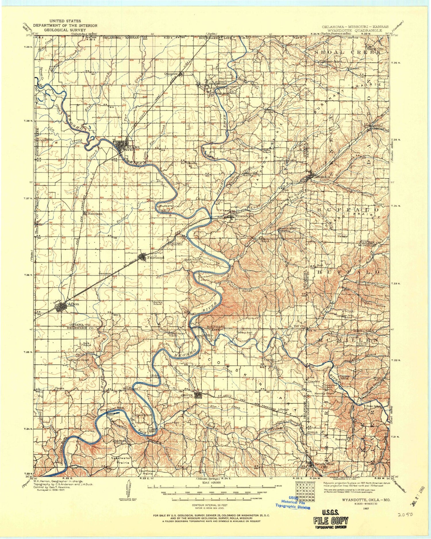
Historic 1907 Wyandotte Oklahoma 30'x30' Topo Map
Couldn't load pickup availability
Historical USGS topographic map of Wyandottein the states of Oklahoma, Kansas, Missouri. Scale: 1:125000. Print size: 18" x 24"
This map was published in 1907 and is in the following counties: Cherokee, Craig, Delaware, McDonald, Newton, Ottawa.
The map contains contour lines, roads, rivers, towns, streams, and lakes. Printed on high-quality waterproof paper with UV fade-resistant inks.
Contains the following named places: Honey Creek, Squaw Creek, Fourmile Creek, Spring River, Tar Creek, Buffalo Creek, Carr Branch, Cowskin Prairie, Little Lost Creek, Patterson Creek, Cave Springs Branch, Fivemile Creek, Rock Branch, Afton, Bad Island, Bee Creek, Bernice, Bernice Point, Big Hollow, Blackberry Island, Blue Star Island, Brush Creek, Camp Cherokee, Carey Bay, Catfish Point, Cedar Point, Chigger Cove, Coal Creek, Commerce, Council Cove, Council Hollow, Courthouse Hollow, Courthouse Prairie, Cow Creek, Devils Hollow, Dilar Cove, Duck Creek, Echo Bay, Elk River, Elm Creek, Elm Creek, Fairland, Fisher Flats, Flatrock Hollow, Flint Branch, Fly Creek, Garrett Creek, Goat Island, Grove, Harrell Park, Hickory Creek, Hickory Creek Island, Hickory Point, Honey Creek Recreation Area, Horse Creek, Horse Creek Cove, Hudson Creek, Indian Hills, Isles' End Cove, Jackson Prairie, Johnson Hollow, Little Elm Creek, Little Fivemile Creek, Little Horse Creek, Lost Creek, Lytle Creek, Mason Springs Valley, Miami, Moccasin Bend, Modoc Valley, Monkey Island, Mud Creek, Mudeater Bend, North Miami, Ogeechee Creek, Osage Hollow, Paradise Point, Patricia Island, Peoria, Potato Hill, Quapaw, Rabbit Island, Reed Point, Riverview Park, Roark Creek, Saddle Island, Shawnee Branch, Snail Creek, Snake Island, Spring Branch, Stoney Point, Sulphur Bend, Sweetwater Hollow, Sweetwater Prairie, Sycamore Cove, Sycamore Creek, Taylor Park, Three Finger Cove, Torbert Park, Twin Bridges State Park, Two Tree Island, Tynon Bluffs, Warren Branch, Weed Island, West Bay, Whitewater Creek, Wilson Point, Windy Creek, Wolf Creek, Wolf Point, Woodward Hollow, Wyandotte, Yankee Bill Prairie, Cayuga, Cleora, Copeland, Dawes, Dennis, Dodge, Dotyville, Eastside, Five Mile, Kellyville, Lincolnville, Moreville, Narcissa, Ogeechee, Ontario, Oseuma, Ottawa, Turkey Ford, Cedar Creek, Ottawa County, Oak Grove, Grand Lake O' The Cherokees, Lake O the Cherokees, Bernice State Park, West Seneca, Market Square, Council Hollow Creek, Township of Quapaw, Township of Peoria, Township of Ottawa, Township of Narcissa, Township of Afton, Township of Council House, Township of Wyandotte, Township 5, Township 6, Afton-Fairland Division, Grove Division, Miami Division, Quapaw Division, Wyandotte Division, City of Commerce, City of Grove, City of Miami, Town of Bernice, Town of Afton, Town of Quapaw, Town of Fairland, Town of North Miami, Town of Peoria, Town of Wyandotte, Butler, Cayuga, Cleora, Copeland, Dennis, Dodge, Dotyville, Narcissa, Ottawa Non-Community, White Water, Zena, Beachner Grain Elevator Number 10, Beachner Grain Elevator Number 2, Squaw Creek, Fourmile Creek, Spring River, Tar Creek, Elm Creek, Lytle Creek, Honey Creek, Spring River, Beeman Hollow, Blackfoot Branch, Buffalo Creek, Carr Branch, Charleton Hollow, Cowskin Prairie, Coy, Dessa, Hart, Honey Lake Hollow, Horner Hollow, Hornet, Kinslow Hollow, Little Lost Creek, MacDougal Branch, North Fork Patterson Creek, Owens Bluff, Patterson Creek, Pine Hollow, Saratoga Hollow, Seneca, Shanghai Hollow, South Fork Patterson Creek, Spring City, Stogdon Creek, Sugar Fork, Swars Prairie, Tiff City, Wela Park, Westview, Willow Branch, Cave Springs Branch, Fivemile Creek, Racine, Rock Branch, Saratoga, Pack, Log, May, White River Hills, Springfield Plain, South West City, Austin Harrison Dam, Austin Harrison Reservoir, Lake Mintahama Dam, Fisher Lake Dam, Southwest City Structure E-1 Dam, Newton County Structure E-1 Dam, Structure E-1 Reservoir, Newton County Structure F-1 Dam, Structure F-1 Reservoir


