MyTopo
Historic 1929 Yellville Arkansas 30'x30' Topo Map
Couldn't load pickup availability
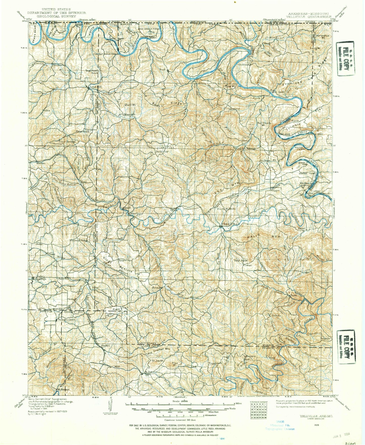
Historical USGS topographic map of Yellville in the state of Arkansas. Scale: 1:125000. Print size: 18" x 24"
This map was published in 1929 and is in the following counties: Baxter, Boone, Marion, Newton, Ozark, Searcy, Taney.
The map contains contour lines, roads, rivers, towns, streams, and lakes. Printed on high-quality waterproof paper with UV fade-resistant inks.
Contains the following named places: Carrollton Hollow, Lead Mine Creek, Windgate Ridge, Anderson Flat, Angel Springs Hollow, Bagget Hollow, Bagley Hollow, Bailey Branch, Baker Spring Branch, Ball Hollow, Barnes Bay, Barney Hollow, Barren Fork, Bayless Island, Beach Hollow, Bear Hill Hollow, Bear Hill Mine, Bear Hollow, Becky Hollow, Big Hollow, Black Bear Hollow, Blue John Creek, Booker Hollow, Boozer Hollow, Boren Fork, Bruce Creek, Brushy Fork, Bryant Hollow, Buck Creek Public Use Area, Buck Hollow, Buck Spring Hollow, Buckley Hollow, Buffalo River State Park, Buie Hollow, Bull Bottom Bluff, Bull Hollow, Bull Shoals Public Use Area, Bull Shoals State Park, Burns Creek, Buzzard Bluff, Buzzard Bluff, Buzzard Roost Hollow, Cabin Creek, Campbell Hollow, Campbell Point, Campbell Ridge, Cane Bottom Bluff, Cane Island, Caney Hollow, Carver Hollow, Cave Hollow, Cave Hollow, Cave Spring Hollow, Cedar Creek, Cedar Creek, Cedar Hollow, Chaney Hollow, Chapman Hollow, Chinquapin Spring Ridge, Clabber Creek, Clear Creek, Clyde Hollow, Coal Pit Hollow, Coffman Cove, Coker Hollow, Cold Spring Hollow, Coldwater Hollow, Cook Cave Hollow, Coon Creek, Coon Hollow, Coon Hollow, Copper Mine Hollow, Copperhead Mine, Cove Hollow, Cow Cove, Cowvat Hollow, Crane Creek, Cross Hollow, Curtis Hollow, Dark Hollow, Davis Hollow, Dean Branch, Deer Cove, Dempsey Hollow, Deshield Fork, Dilday Hollow, Dixon Hollow, Dry Branch, Dry Music Creek, Dry Prong Spring Creek, Dugget Creek, East Fork Clear Creek, East Prong Town Branch, Elbow Hollow, Elbow Hollow, Elixir Hollow, Elm Branch, Elm Cave Hollow, Elm Hollow, Erie Ozark Mine, Eros, Everton, Ezell Hollow, Fairview, Fallen Ash Creek, Fee Hollow, Findlay Hollow, Five Finger Cove, Flat Hollow, Flat Hollow Branch, Fox Hollow, Frost Point, Gay Ridge, George Treat Hollow, Georges Creek, Goat Bluff, Granny Price Hollow, Grapevine Hollow, Gravelly Hollow, Greasy Creek, Green Campbell Hollow, Green Haw Hollow, Gulf Hollow, Gunnel Fork, Ham Flat, Hampton Branch, Hampton Creek, Harris Hollow, Hawkins Hollow, Hightower Creek, Highway 125 Public Use Area, Hogskin Creek, Hogskin Hollow, Hollingsworth Cove, Horse Hollow, Horton Creek, Howard Creek, Hunnicut Hollow, Hurricane Branch, Hurricane Creek, Ingram Creek, Ingram Creek, Iola Hollow, Jackpot Hollow, Jackpot Mine, Jenkins Branch, Jim Hollow, John Treat Hollow, Johnnie Creek, Jones Hollow, Jones Hollow, Keele Hollow, Keystone Hollow, Kimball Creek, Kings Branch, Kings Prairie, Lakeview Public Use Area, Lay Creek, Lay Falls, Lead Drift Mine, Lead Mine Creek, Lead Mine Hollow, Leader Hollow, Lean Mine Hollow, Lee Mountain, Leon Hollow, Linley Ridge, Linton Ridge, Lithia Creek, Little Beach Hollow, Little Cedar Creek, Little Fool Creek, Little Georges Creek, Little Music Creek, Little North Fork White River, Little Panther Creek, Little Rush Creek, Little Sugar Creek, Locust Creek, London Spring Hollow, Lonely Hollow, Lost Bell Mine, Mackey Hollow, Madison Hollow, Madison Mine, Markle Hollow, Markle Mine, Marshall Branch, Marshall Hollow, Martin Hollow, Maumee Hollow, McBridge Hollow, McKinney Hollow, Meeks Creek, Mill Branch, Mill Branch, Mill Creek, Mill Hollow, Mineral Hollow, Mining House Hollow, Mitchell Creek, Moccasin Creek, Monkey Hill Mine, Monroe Hollow, Moon Cove, Moore Hollow, Mountain Creek, Mud Hollow, Ralph Natural Bridge, Neilon Creek, Nelson Cove, Noe Creek, Nokomis Hollow, North Fork Tomahawk Creek, North Star Hollow, Oak Hollow, Oakland Public Use Area, Onwata Hollow, Onwata Mine, Open Hollow, Osborne Hollow, Ozard Isle Public Use Area, Pannell Hollow, Panther Creek, Parker Hollow, Parks Hollow, Pedlo Branch, Peter Hollow, Pig Pen Hollow, Pigeon Roost Branch, Pigeon Roost Mine, Pilot Rock Mine, Pine Flat, Pine Hollow, Pine Hollow, Pine Hollow