MyTopo
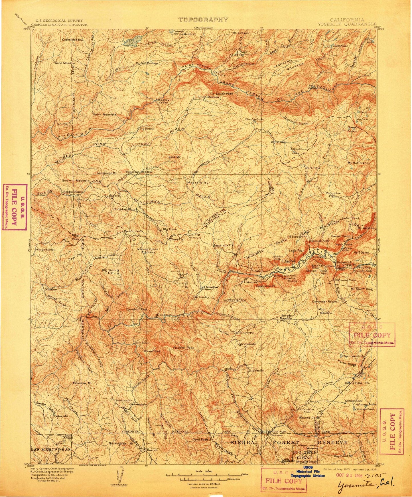
Historic 1903 Yosemite California 30'x30' Topo Map
Couldn't load pickup availability
Historical USGS topographic map of Yosemite in the state of California. Scale: 1:125000. Print size: 17" x 24"
This map was published in 1903 and is in the following counties: Madera, Mariposa, Tuolumne.
The map contains contour lines, roads, rivers, towns, streams, and lakes. Printed on high-quality waterproof paper with UV fade-resistant inks.
Contains the following named places: Battalion Pass, Halfmoon Meadow, Horizon Ridge, Little Grizzly Flat, Lower Yosemite Fall, Lukens Lake, McSwain Meadows, Pilot Peak, Rancheria Flat, Mount Savage, Siesta Lake, Bear Wallow Spur, Marble Point, Roundtree Saddle, Turner Ridge, Upper Yosemite Falls, Wegner Lake, Yosemite Point, Indian Canyon, Sequoia, Hetch Hetchy Valley, Henness Branch, Harden Ranch, Buena Vista Pass, Bridalveil Meadow, Lehamite Falls, Little Hetch Hetchy Valley, Pohono Meadow, Ten Lakes Pass, Yosemite Falls, Rail Creek, Beehive, Crocker Meadow, El Capitan Moraine, Harden Gardens, Crane Flat, Hodgdon Meadow, North Mountain, Preston Falls, Cottonwood Meadow, Arrowhead Spire, Eagle Tower, Lost Arrow, Jones Point, Jones Meadow, Tenaya Canyon, Watkins Pinnacles, Ahwahnee Meadow, Lost Lake, Silver Apron, Bridalveil Moraine, Devils Dance Floor, Elevenmile Meadow, K P Pinnacle, Summit Meadow, The Rostrum, Yosemite West, Crow Peak, Mosquito Creek, Dutchman Lake, Berkeley-Tuolumne Campground, Carlon Campground, Peach Growers, Cherry Valley Campground, Jawbone Station, Lake Eleanor Campgound, Woods Ridge Lookout, Hetch Hetchy Campground, Miguel Meadow Ranger Station, Eagle Peak Trail, Porcupine Flat Campground, Yosemite Falls Trail, Cathedral Beach Picnic Area, Clark Point, El Capitan Picnic Area, Four Mile Trail, Group Camp, Housekeeping Camp, Lower Pines Campground, Lower River Campground, Mist Trail, North Pines Campground, Panorama Trail, Sentinel Beach Picnic Area, Sunnyside Campground, Upper Pines Campground, Upper River Campground, Yosemite Lodge, Discovery View, Chilnualna Fall Trail, Big Creek, Bridalveil Campground, Buena Vista Trail, Cathedral Creek, Coyote Rocks, Dark Hole, Deer Camp, Diving Board, Edson Lake, Empire Meadows, Mount Gibson, Glacier Point, Grand Mountain, Grant Lakes, Half Dome, Happy Isles, Harden Lake, Mount Hoffmann, Hoffmann Creek, Iron Creek, Laurel Creek, Lower Brother, Middle Brother, Mirror Lake, Mono Meadow, Mono Meadow Trail, Porcupine Creek, Rush Creek, Clouds Rest Trail, Grand Canyon of the Tuolumne River, Half Dome Trail, Split Pinnacle, Squirrel Creek, Stovepipe, Summit Campground, Sunrise Creek, Ten Lakes Trail, Washburn Point, Wawona Campground, Devil Peak, Double Rock, Eagle Creek, Eagle Peak Creek, Eagle Peak Meadows, Elevenmile Creek, Emerald Pool, Panorama Cliff, Pate Valley, Peregoy Meadow, Piute Creek, Porcupine Flat, Pothole Meadows, Profile Cliff, Quarter Domes, Saddle Horse Lake, Sentinel Creek, Sentinel Dome, Sentinel Fall, Sentinel Rock, Sierra Point, Smith Peak, Deep Canyon, Snow Creek, Snow Creek Falls, Snow Flat, Staircase Falls, Starr King Lake, Starr King Meadow, Mount Starr King, Table Lake, Tamarack Flat, Yosemite Creek, Alder Creek, Basket Dome, Bishop Creek, Mount Broderick, Castle Cliffs, Chilnualna Creek, Clark Fork, Colby Mountain, Columbia Rock, Illilouette Falls, Illilouette Gorge, Illilouette Ridge, Indian Canyon Creek, Indian Ridge, Indian Rock, Irwin Bright Lake, Jawbone Creek, Le Conte Point, Lehamite Creek, Leidig Meadow, Liberty Cap, Lost Bear Meadow, Morrison Creek, Muir Gorge, Neall Lake, Nevada Fall, North Dome, Ostrander Rocks, Rancheria Falls, Rancheria Mountain, Red Creek, Register Creek, Rocky Point, Rodgers Canyon, Rodgers Meadow, Royal Arch Cascade, Royal Arch Creek, Royal Arches, Bluejay Creek, Breeze Creek, Little Yosemite Valley, Ten Lakes, Tenaya Creek, The Fissures, Tiltill Valley, Vernal Fall, Washington Column, Mount Watkins, White Fir Creek, Yosemite National Park, Abernathy Meadow, Ackerson Creek, Ackerson Meadow, Ackerson Mountain, Anderson Flat, Arch Rock Entrance, Artist Creek, Artist Point, Aspen Valley, Avalanche Creek, Badger Pass, Badger Pass Ski Area, Bald Mountain, Bear Mountain, Big Creek, Big Creek Basin, Big Grizzly Creek, Big Grizzly Flat, Big Grizzly Mountain, Big Tree, Biledo Meadow, Birch Lake, Bonell Gulch, Bridalveil Creek