MyTopo
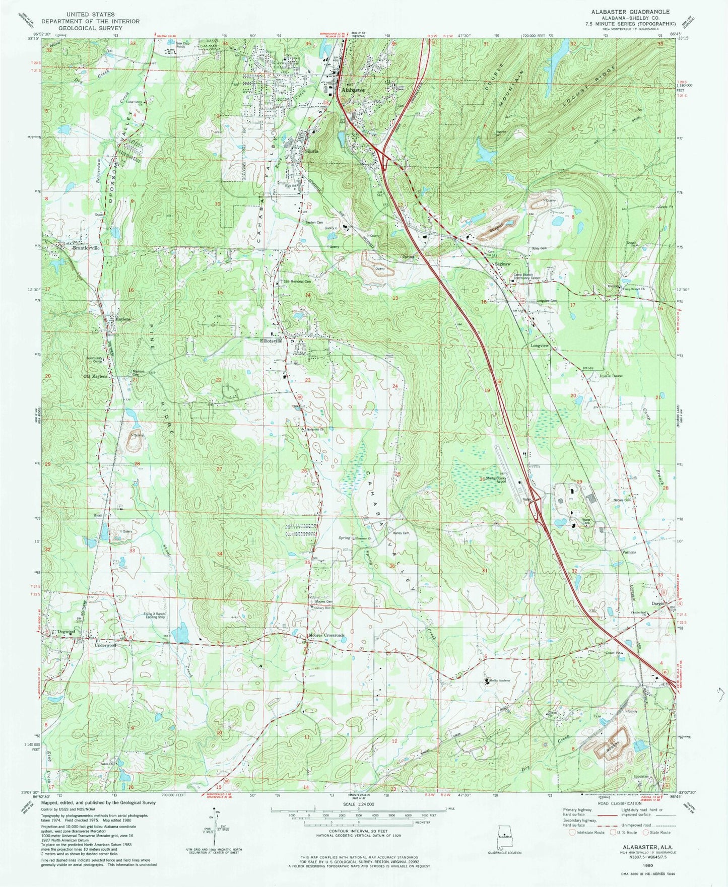
Classic USGS Alabaster Alabama 7.5'x7.5' Topo Map
Couldn't load pickup availability
Historical USGS topographic quad map of Alabaster in the state of Alabama. Typical map scale is 1:24,000, but may vary for certain years, if available. Print size: 24" x 27"
This quadrangle is in the following counties: Shelby.
The map contains contour lines, roads, rivers, towns, and lakes. Printed on high-quality waterproof paper with UV fade-resistant inks, and shipped rolled.
Contains the following named places: Alabaster, Blue Spring, Cedar Grove School, Dargin, Dogwood, Ebenezer Church, Elliottsville Church, Brantleyville, Maylene, Old Maylene, Opossum Valley, Pasqua, Pine Ridge, Saginaw, Siluria, Varnons, Flying X Ranch Airport, Shelby County Airport, Salter Lake, Salter Dam, Fultons Lake, Fulton Lake Dam, Kimberly-Clark Dam, Kimberly-Clark Lake, Alabaster Shopping Center, Benton Cemetery, Black Cemetery, Brantleyville Church, Calvary Hill Church, Camp Branch, Camp Branch Community Center, Cedar Grove Cemetery, Cedar Grove Cemetery, Cumberland Church, Dargin Cemetery, Eaglewood Estates, Elliotsville, Galilee Church, Goodson Cemetery, Glen Forest, Grace Church, Harless Cemetery, Jones Bailey Cemetery, Longview Cemetery, Maylene Cemetery, Mission Hills, Moores Cemetery, Moores Crossroad Church, Moores Crossroads, Moores Crossroads Cemetery, Nabors Cemetery, New Mount Mariah Church, Ryan Cemetery, Ryan Baptist Church, Salem Cemetery, Salem Church, Scottsdale, Shelby Academy, Siluria Cemetery, Still Memorial Cemetery, Thompson High School, Thompson Middle School, Underwood, Verlie, Willmay, Willow Glen, Woodland Hills, Outreach Church, Ozley Cemetery, Buck Creek Spring, Camp Branch Elementary School (historical), David Lindsay Cemetery, Dogwood Elementary School (historical), Griffin Spring, Maylene Elementary School (historical), Stancel Spring, Thompson Elementary School, Nelson Cemetery, Wildwood Cemetery, Central United Methodist Church, First Baptist Church of Alabaster, Siluria Baptist Church, Camp Branch United Methodist Church, Longview, Monte-Sil Baptist Church, Garrett Cemetery, Ryan, Stems, Cahaba Valley, Flora Post Office (historical), Lees Cove Post Office (historical), Woodsboro Post Office (historical), Maylene Post Office, Community Church, Country Hills, Dogwood Baptist Church, Ivanhoe, Meadow Green, Montalla Acres, Monte Bello, Underwood Baptist Church, Victory Temple Church, City of Alabaster, Calera Quarry, Shelby County Sheriffs Office - West Substation, Calera Fire and Rescue Station 2, Saginaw Volunteer Fire Department, Alabaster Fire Department Station 1, County 17 Volunteer Fire Department, Alabaster Fire Department Station 3, Alabaster Fire Department Station 2, West Shelby Fire and Rescue District Station 2, West Shelby Fire and Rescue District Station 1, Montevallo Fire and Rescue Station 2, Alabama National Cemetery, Alabaster Police Department, Saginaw Post Office, Alabaster Post Office