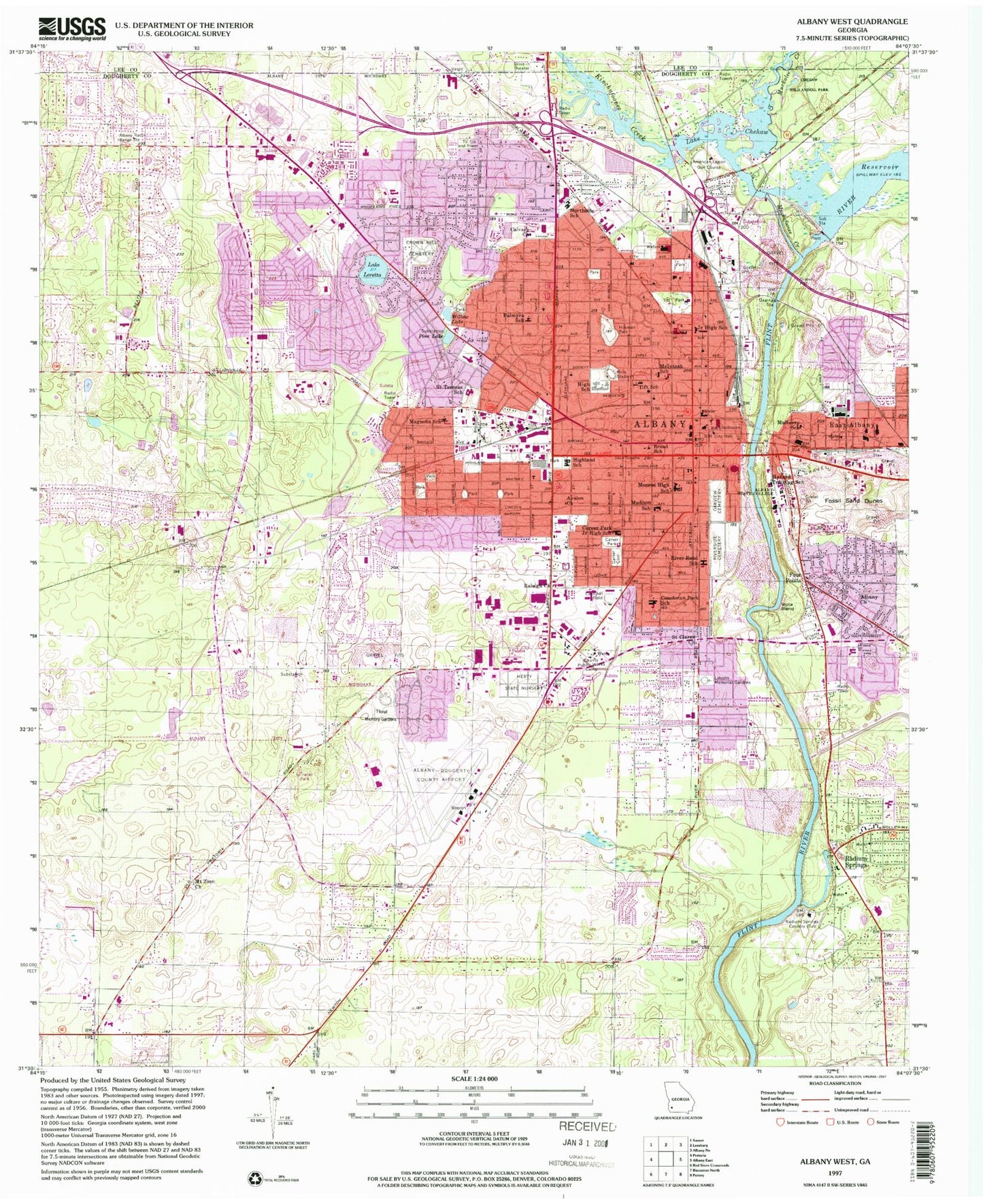
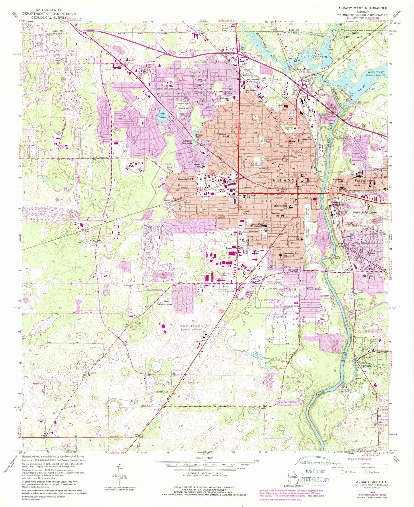
MyTopo
Classic USGS Albany West Georgia 7.5'x7.5' Topo Map
Couldn't load pickup availability
Historical USGS topographic quad map of Albany West in the state of Georgia. Map scale may vary for some years, but is generally around 1:24,000. Print size is approximately 24" x 27"
This quadrangle is in the following counties: Dougherty, Lee.
The map contains contour lines, roads, rivers, towns, and lakes. Printed on high-quality waterproof paper with UV fade-resistant inks, and shipped rolled.
Contains the following named places: Albany, Albany Academy, Albany Area Vocational High School, Albany Church, Albany Fire Department Station 1, Albany Fire Department Station 2, Albany Fire Department Station 4, Albany Fire Department Station 5, Albany Fire Department Station 6, Albany Fire Department Station 8, Albany Gun Club, Albany High School, Albany Junior College, Albany Mall Shopping Center, Albany Middle School, Albany Municipal Auditorium, Albany Plaza Shopping Center, Albany Police Department, Albany Post Office, Albany Railroad Depot Historic District, Albany State University, Albany Transitional Center, Albany Vocational-Technical School, American Legion Golf Course, Audubon, Avalon, Avalon Church, Avondale, Avondale Acres, Azalea Terrace, Barclay Shopping Center, Brentwood, Broad School, Brookwood, Calvary Church, Carnegie Library of Albany, Carver Cemetery, Carver Park, Cedar Heights, Chehaw State Park, Cherokee Heights, City of Albany, Clearview, Cleveland Heights, Coachman Park, Coachman Park School, Colonial Place, Colonial Village, Country Club Estates, Cross Station Shopping Center, Crown Hill Cemetery, Darton College Campus Police Department, Dawson Heights, Deerfield-Windsor Lower School, Deerfield-Windsor Upper School, Dixie Heights, Dixieland, Dougherty County, Dougherty County Courthouse, Dougherty County Jail, Dougherty County Police Department, Dougherty County School Police Department, Dougherty County Sheriff's Office, Dougherty County Trainable Mental Retarded Center, East Towne, Edgewood, Elon Village, Eugemar, Evergreen, Exchange Club Fairgrounds, Fairfield, Federal Post Office, Flint River Dam, Flint Street Grammar School, Flintland, Flintside, Flintside Elementary School, Floral Memory Gardens, Florary, Forest Park, Fossil Sand Dunes, Four Points, Fulford Heights, Gailshar Gardens, Garden Hill, Gloriana, Gordon Commercial Park, Gordon Heights, Green Acres, Greenbrier, Groveland, Haley Memorial Youth Center, Harmon Heights, Hazard Training School, Hedrick Park, Herty State Nursery, Highland Park, Highland School, Hillcrest, Hillingdon, Hillside, Hilsman Park, Hinds, Hollywood, Hotalihuyana, Hunters Mill Shopping Center, Kalmon, Ken Gardens, Kinchafoonee Creek, Lafayette Plaza Post Office, Lake Cornelia, Lake Loretta, Lake Park, Lake Park Shopping Center, Lake Worth, Lakeside, Largo Plaza Shopping Center, Lee Branch Library, Lincoln Fundamental School, Lincoln Heights, Madison Park, Madison School, Magnolia School, Magnolia Square Shopping Center, Malone, Mamie Brosnan Elementary School, Margaret Road Hazard Library, Martin Luther King Junior Elementary School, Martin Luther King Junior Middle School, McIntosh School, Merry Acres, Merry Acres Elementary School, Midtown Mall Shopping Center, Midtown Shopping Center, Mills Stadium, Mockingbird Estates, Monroe High School, Morningside, Morningside Elementary School, Mount Zion Church, Muckafoonee Creek, Muckalee Creek, Mulberry Heights, Mulberry School, Murray Hill, North Slappy Heights, Northeast Industrial Park, Northend, Northend Addition, Northside, Northside School, Northwest Branch Library, Oakview Cemetery, Palmyra Acres, Palmyra Heights, Palmyra Homes, Palmyra Park Heliport, Palmyra School, Phoebe Putney Memorial Hospital, Phoebe Putney Memorial Hospital - North Campus, Pine Forest Raquet Club, Pine Lake, Plantation Hills, Pointe North, Radium Crossing Shopping Center, Radium Gardens, Radium Springs, Radium Springs Country Club, Radium Springs Elementary School, Radium Springs Middle School, Ragsdale, Raleigh Church, Rawls Pond, Rawson Park, Relswood Terrace, Rio Vista, River Road, Riverdale, Riverside Cemetery, Riverside Park, Riverview, Riverview Academy, Road Pecan Park, Rolling Acres, Roselawn Garden of Memory Cemetery, Saint Andrews, Saint Teresas School, Shackleford Park, Shackleford Place, Shackleford Shopping Center, Sherwood Acres, Sherwood Acres Elementary School, Shoppers Corner Shopping Center, Slappey Industrial Park, Southgate, Southgate Shopping Center, Southside Middle School, Southwest Georgia Regional Airport, Southwest Georgia Regional Airport Fire Department, Southwest Georgia Regional Airport Police, Southwind, Sunny Acres, Sunnyland, Third Avenue Shopping Center, Tift Park, Tift School, Town and Country Acres, Valley Park, Village Green Shopping Center, Viola Bend, WALG-AM (Albany), Walters, Washington Heights, West Highland, West Town, West Town Elementary School, Westgate, Westhampton, Westover, Westover Crossings Shopping Center, Westover High School, Westtown Branch Library, Westwood, WGPC-AM (Albany), WGPC-FM (Albany), Whispering Pines, Wildcross, Willow Lake, Winterwood, WJYZ-AM (Albany), WKAK-FM (Albany), Woodbridge, Woodland, ZIP Codes: 31701, 31707