MyTopo
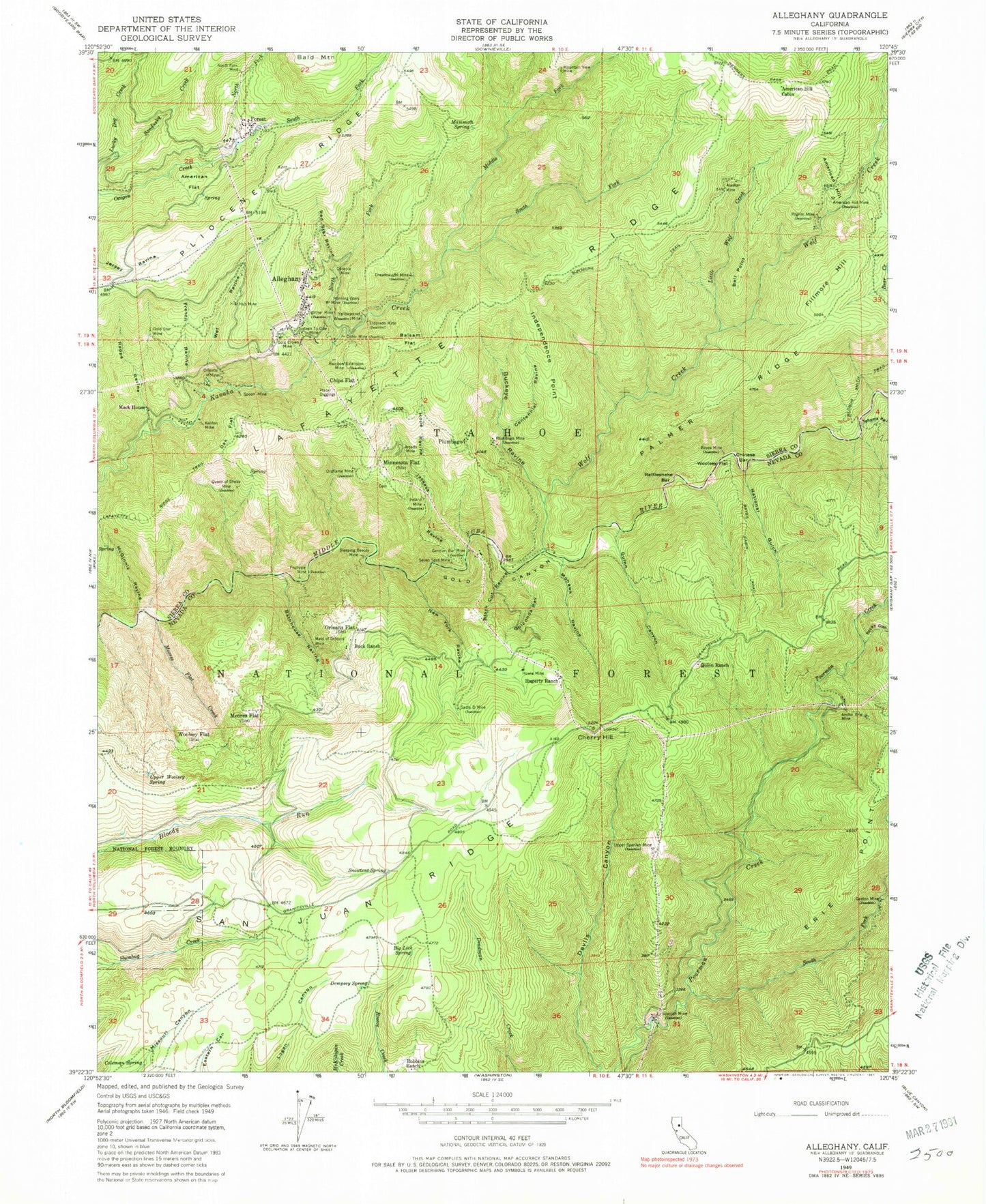
Classic USGS Alleghany California 7.5'x7.5' Topo Map
Couldn't load pickup availability
Historical USGS topographic quad map of Alleghany in the state of California. Typical map scale is 1:24,000, but may vary for certain years, if available. Print size: 24" x 27"
This quadrangle is in the following counties: Nevada, Sierra.
The map contains contour lines, roads, rivers, towns, and lakes. Printed on high-quality waterproof paper with UV fade-resistant inks, and shipped rolled.
Contains the following named places: Rapps Ravine, Alaskan Mine, Alleghany, American Flat, American Hill Cabin, American Hill Mine, Ancho Erie Mine, Arcade Mine, Balsam Flat, Bathhouse Ravine, Bayes Cabin Road, Bayes Mine, Bedbug Smith Trail, Bell Point, Big Lick Spring, Black Cut Ravine, Buck Ranch, Buckeye Ravine, Centennial Ravine, Cherry Hill, Chinese Bar, Chips Flat, Coleman Spring, Dempsey Spring, Dreadnaught Mine, Eldorado Mine, Erie Point, French Ravine, Fruitvale Mine, Gaston Mine, German Bar Mine, Golconda Ravine, Gold Canyon, Gold Crown Mine, Gold Star Mine, Hagerty Ranch, Hope Ravine, Howie Mine, Hub Mine, Independence Point, Ireland Mine, Jackass Ravine, Kenton Mine, Little Wolf Creek, Mack House, Maid of Orleans Mine, Mammoth Spring, McGinnis Ravine, Middle Fork Kanaka Creek, Minnesota Flat, Mohawk Ravine, Moore Flat Creek, Moores Flat, Morning Glory Mine, Mountain View Mine, National Gulch, New York Ravine, North Fork Kanaka Creek, North Fork Mine, North Fork Oregon Creek, Oak Flat, Oceola Mine, Ophir Mine, Oriental Mine, Orleans Flat, Oroflame Mine, Pilgrim Mine, Placer Diggings, Plumbago Mine, Queen of Sheba Mine, Quinn Canyon, Quinn Ranch, Rainbow Extension Mine, Rattlesnake Bar, Red Star Ravine, Robbins Ranch, Rocky Glen, Sadie D Mine, Sandusky Creek, Seven Spot Mine, Sixteen to One Mine, Sleeping Beauty Mine, Lafayette Ridge, San Juan Ridge, Snowtent Spring, South Fork Kanaka Creek, South Fork Oregon Creek, South Fork Poorman Creek, Spanish Mine, Spoon Mine, Sunshine Trail, Tehama Ravine, Tighner Mine, Upper Spanish Mine, Upper Woolsey Spring, Wet Ravine, Wolf Creek, Woolsey Flat, Woolsey Flat, Yellowjacked Mine, American Hill, Fillmore Hill, Forest, Plumbago, Jackass Spring, McCulloch Spring, Malone Orchard, Dillon (historical), Shands (historical), Snow Point (historical), Snow Tent (historical), Woolsey Cabin (historical), American Hill (historical), McCullough Ranch (historical), Centerville (historical), Cold Springs Ranch (historical), McCullough Spring, Smiths Flat, Tulpehocke Flat, Unionville (historical), Fellows Mill (historical), Freds Ranch (historical), Hells Half Acre, Osceola Mine, Sawmill Flat, Alleghany Census Designated Place, Alleghany Volunteer Fire Department, Alleghany Post Office, Minnesota Flat Cemetery, Moores Flat Cemetery, Alleghany Cemetery, Forest City Cemetery, Rapps Ravine, Alaskan Mine, Alleghany, American Flat, American Hill Cabin, American Hill Mine, Ancho Erie Mine, Arcade Mine, Balsam Flat, Bathhouse Ravine, Bayes Cabin Road, Bayes Mine, Bedbug Smith Trail, Bell Point, Big Lick Spring, Black Cut Ravine, Buck Ranch, Buckeye Ravine, Centennial Ravine, Cherry Hill, Chinese Bar, Chips Flat, Coleman Spring, Dempsey Spring, Dreadnaught Mine, Eldorado Mine, Erie Point, French Ravine, Fruitvale Mine, Gaston Mine, German Bar Mine, Golconda Ravine, Gold Canyon, Gold Crown Mine, Gold Star Mine, Hagerty Ranch, Hope Ravine, Howie Mine, Hub Mine, Independence Point, Ireland Mine, Jackass Ravine, Kenton Mine, Little Wolf Creek, Mack House, Maid of Orleans Mine, Mammoth Spring, McGinnis Ravine, Middle Fork Kanaka Creek, Minnesota Flat, Mohawk Ravine, Moore Flat Creek, Moores Flat, Morning Glory Mine, Mountain View Mine, National Gulch, New York Ravine, North Fork Kanaka Creek, North Fork Mine, North Fork Oregon Creek, Oak Flat, Oceola Mine, Ophir Mine, Oriental Mine, Orleans Flat, Oroflame Mine, Pilgrim Mine, Placer Diggings, Plumbago Mine, Queen of Sheba Mine, Quinn Canyon, Quinn Ranch, Rainbow Extension Mine, Rattlesnake Bar, Red Star Ravine, Robbins Ranch, Rocky Glen, Sadie D Mine, Sandusky Creek, Seven Spot Mine, Sixteen to One Mine, Sleeping Beauty Mine, Lafayette Ridge, San Juan Ridge, Snowtent Spring, South Fork Kanaka Creek, South Fork Oregon Creek, South Fork Poorman Creek, Spanish Mine, Spoon Mine, Sunshine Trail, Tehama Ravine, Tighner Mine, Upper Spanish Mine, Upper Woolsey Spring, Wet Ravine, Wolf Creek, Woolsey Flat, Woolsey Flat, Yellowjacked Mine, American Hill, Fillmore Hill, Forest, Plumbago