MyTopo
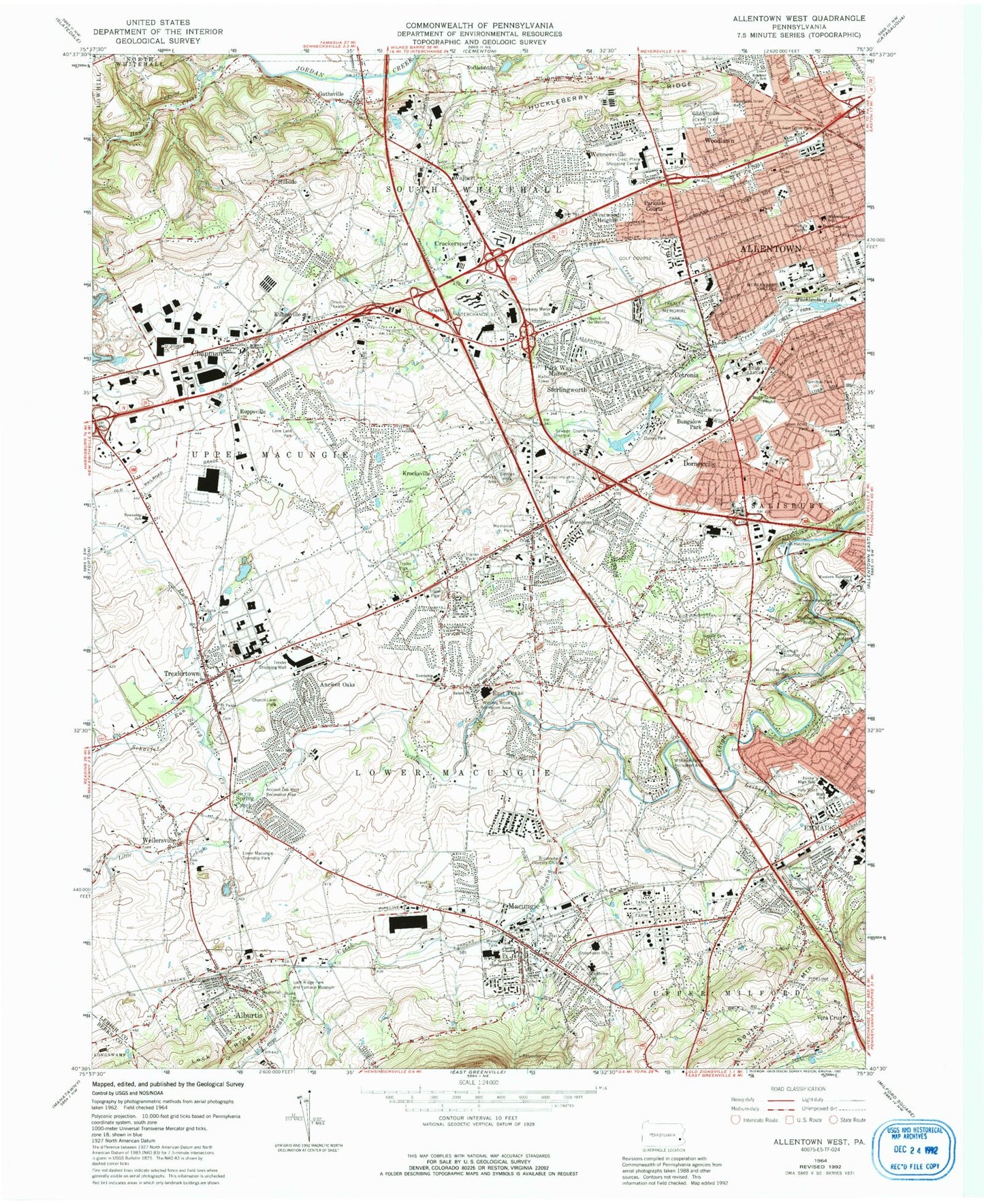
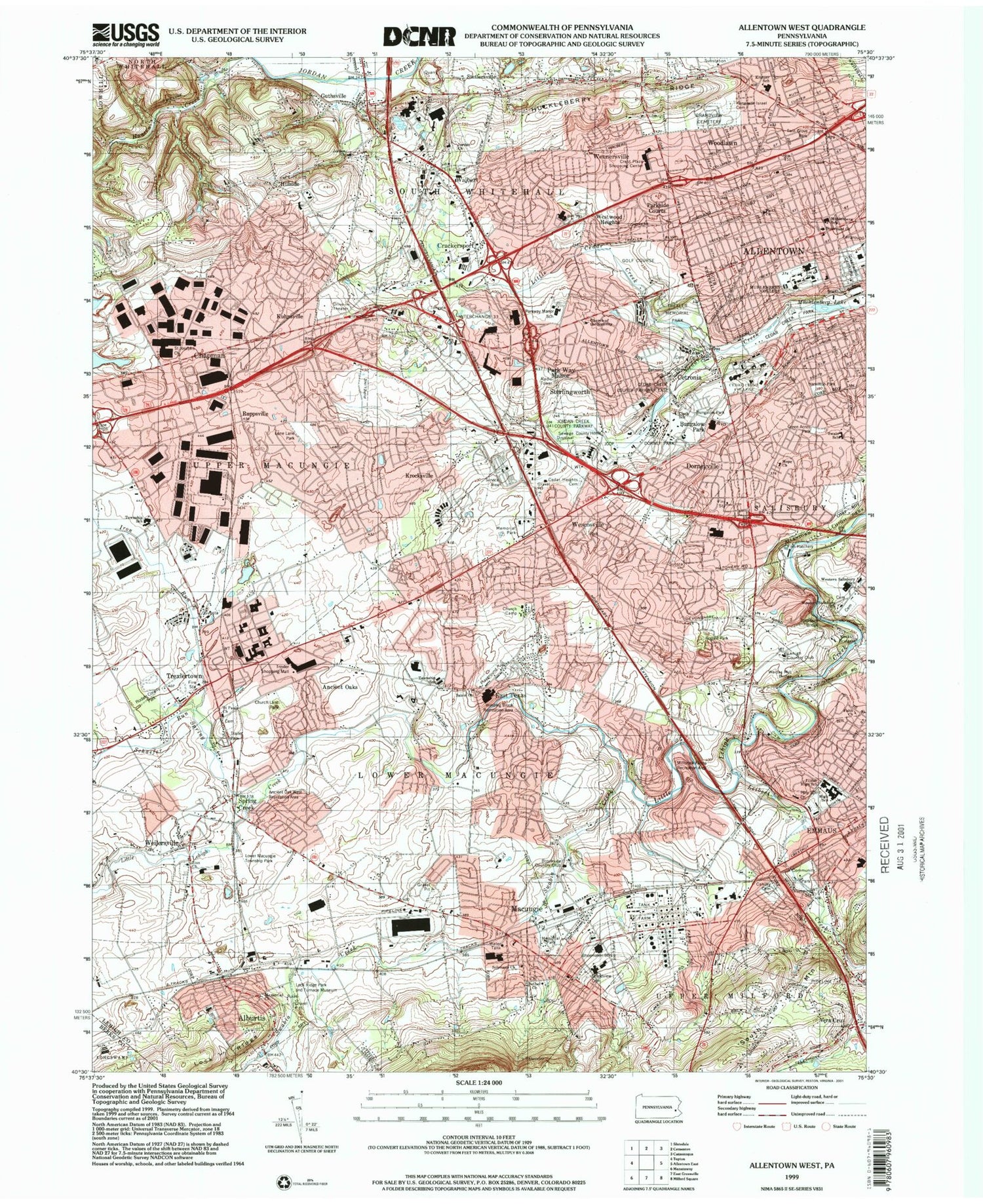
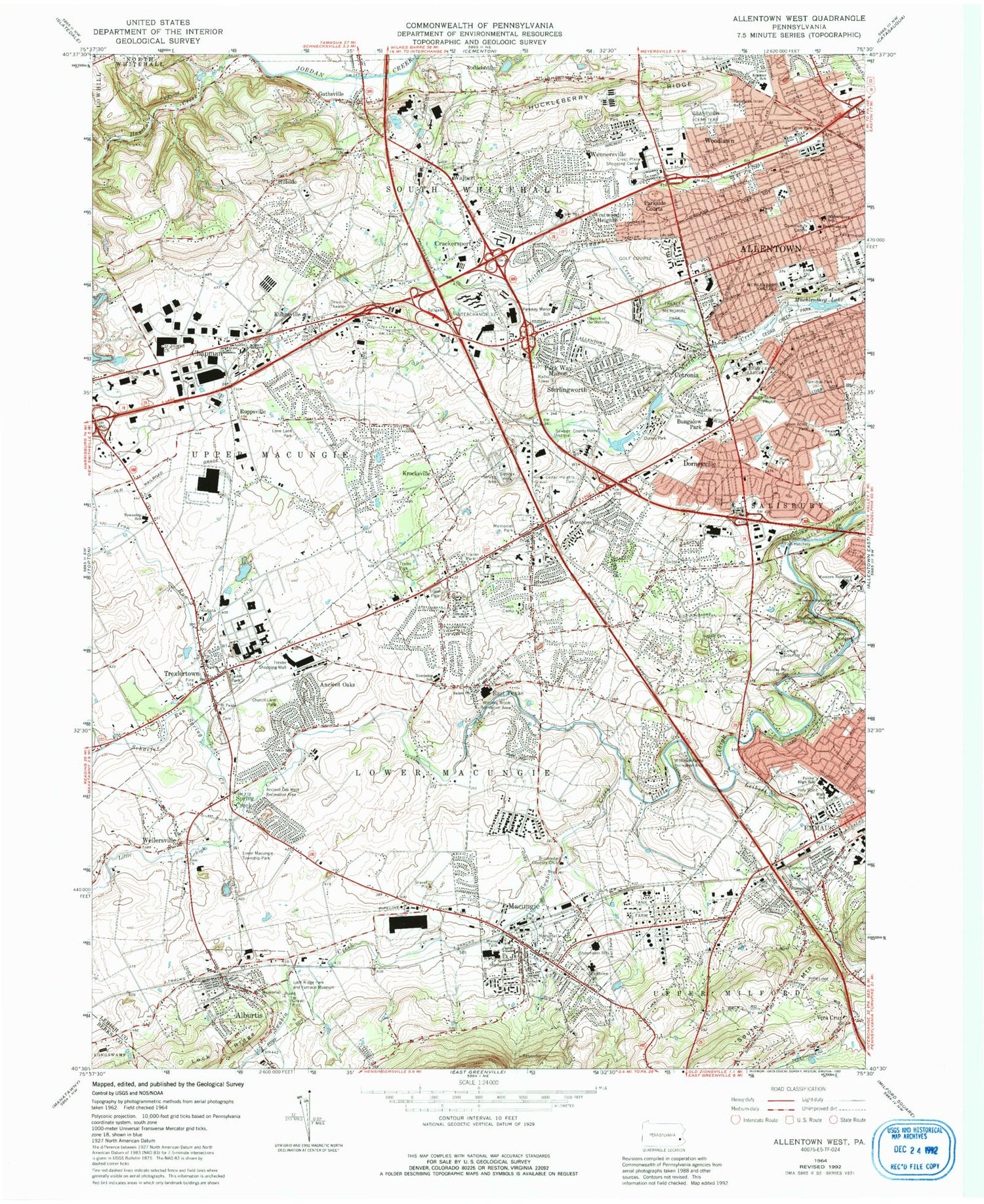
Classic USGS Allentown West Pennsylvania 7.5'x7.5' Topo Map
Couldn't load pickup availability
Historical USGS topographic quad map of Allentown West in the state of Pennsylvania. Typical map scale is 1:24,000, but may vary for certain years, if available. Print size: 24" x 27"
This quadrangle is in the following counties: Berks, Lehigh.
The map contains contour lines, roads, rivers, towns, and lakes. Printed on high-quality waterproof paper with UV fade-resistant inks, and shipped rolled.
Contains the following named places: Alburtis, Ancient Oaks, Bethel Church, Boulevard Church, Bungalow Park, Calvary Cemetery, Camp Moritz, Cedar Church, Cedar Crest College, Cedar Heights Cemetery, Cetronia, Chapman, Church of the Nativity, Clark School, Crackersport, Dorney Park, Dorneyville, East Texas, Faith Church, Fairview Cemetery, Grandview Cemetery, Greenwood Cemetery, Guthsville, Hillside, Hope Church, Huckleberry Ridge, Iron Run, Jordan Church, Jordan Church, Kecks Bridge, Keneseth Israel Cemetery, Krocksville, Kuhnsville, Macungie, Memorial Church, Memorial Park, Memorial Park, Muhlenberg College, Park Way Manor, Parkside Courts, Ruppsville, Saint Josephs Church, Saint Pauls Church, Salem Church, Schaefer Run, Solomons Church, South Mountain, Spring Creek, Sterlingworth, Stevens School, Swain School, Trexler Memorial Park, Trexlertown, Walbert, Weidas Mill Bridge, Weilersville, Wennersville, Wescosville, Western Salisbury Church, Westwood Heights, Woodlawn, Zion Church, Faith Church, Grace Church, Leibert Creek, Swabia Creek, Knepper Airport (historical), Butz Airport, Nash Airport (historical), Cedarbrook County Home, Wescosville Memorial Park, Rathburn Bridge, Macungie Memorial Park, Litzenberg, Minesite, Hilltown, Griesemersville, Sinking Run, Haines, Crane (historical), Centreville, Eckert (historical), Guth, Daschers School, Miller School, Riegel School, Merkle Station, Emmaus Community Park, WMUH-FM (Allentown), Poorhouse Spring, Trexler Spring, Mosser Spring, Fish Hatchery Spring, Lake Muhlenberg, Stetlersville, Spring Creek, Allentown Golf Course, Vera Cruz Jasper Pits, Cedar Creek Dam Number One, Mill Dam, Mill Dam, Lock Ridge, Cedar Creek Park, Crest Plaza Shopping Center, Upper Macungie Township School, Lehigh County, Little Cedar Creek, Crest Plaza Shopping Center, Parkway Manor Elementary School, Cetronia Elementary School, Kratzer Elementary School, Muhlenberg Elementary School, Western Salisbury Elementary School, Lower Macungie Township School, Alburtis Elementary School, Emmaus Junior High School, Emmaus High School, Macungie Elementary School, East Fogelsville, Schantz Spring, Trexler Mall, Chapperal Ridge, Holiday Plaza, William Allen Senior High School, Springhouse Junior High School, Fogelsville Elementary School, Eyer Junior High School, Shoemaker Elementary School, Wescosville Elementary School, Salisbury Middle School, Brookside Country Club, Lehigh Country Club, Macungie Mack Heliport, HGF Airport, Allentown and Sacred Heart Hospital Center Airport, Borough of Alburtis, Borough of Macungie, Township of Lower Macungie, Township of South Whitehall, Township of Upper Macungie, Lock Ridge Park and Furnace Museum, Lower Macungie Township Park, Ancient Oak West Recreation Area, Church Lane Park, Lone Lane Park, Twin Grove Park, Green Acres Park, Jordan Creek County Park, Rodale County Park, Winding Brook Recreation Area, Millbrook Farms Recreation Area, Butz Hall, Cressman Library, Cynthia Blaschak Softball Field, Hartzel Hall, Lees Hall, President's House - Cedar Crest College, Steinbright Hall, The Administration Building, The Dorothy Rider Pool Science Center, The Miller Family Building, The Rodale Aquatic Center for Civic Health, Tompkins College Center, Ancient Oaks Census Designated Place, Dorneyville Census Designated Place, Cetronia Census Designated Place, Wescosville Census Designated Place, Trexlertown Census Designated Place, Vera Cruz Fire Department Station 28, Macungie Fire Company Station 15, Alburtis Volunteer Fire Department Station 1, Lower Macungie Fire Department Station 30, Western Salisbury Volunteer Fire Company Station 31, Greenawalds Fire and Rescue Station 11, Allentown Fire Department West End Fire Station, Goodwill Fire Company Station 25, Woodlawn Fire Department Station 32, Cetronia Fire Department Station 3, Lehigh Valley Hospital - Cedar Crest, Westfield Hospital, Coordinated Health Hospital Allentown Campus, Cetronia Ambulance Corps, Erbrick Medical Transport, Macungie Ambulance Corps, Alburtis Post Office, Wescosville Post Office, Trexlertown Post Office, East Texas Post Office, Macungie Post Office, South Whitehall Township Police Department, Alburtis Borough Police Department, Macungie Borough Police Department, Saint Anne's Episcopal Church Memorial Garden, Jordan Lutheran Cemetery - New, Resurrection Cemetery, Lutheran Church of the Holy Spirit Memorial Garden, First Presbyterian Church Memorial Garden, Saint Pauls United Church of Christ Cemetery, Lehigh Zion Cemetery, Trexler Park Cemetery, Macungie Baptist Church Cemetery, Cedar Church Cemetery, Solomons United Church of Christ Cemetery, Jordan United Church of Christ Cemetery, Jerusalem Western Salisbury Church Cemetery, Salem United Methodist Church Cemetery, Bethany United Methodist Cemetery