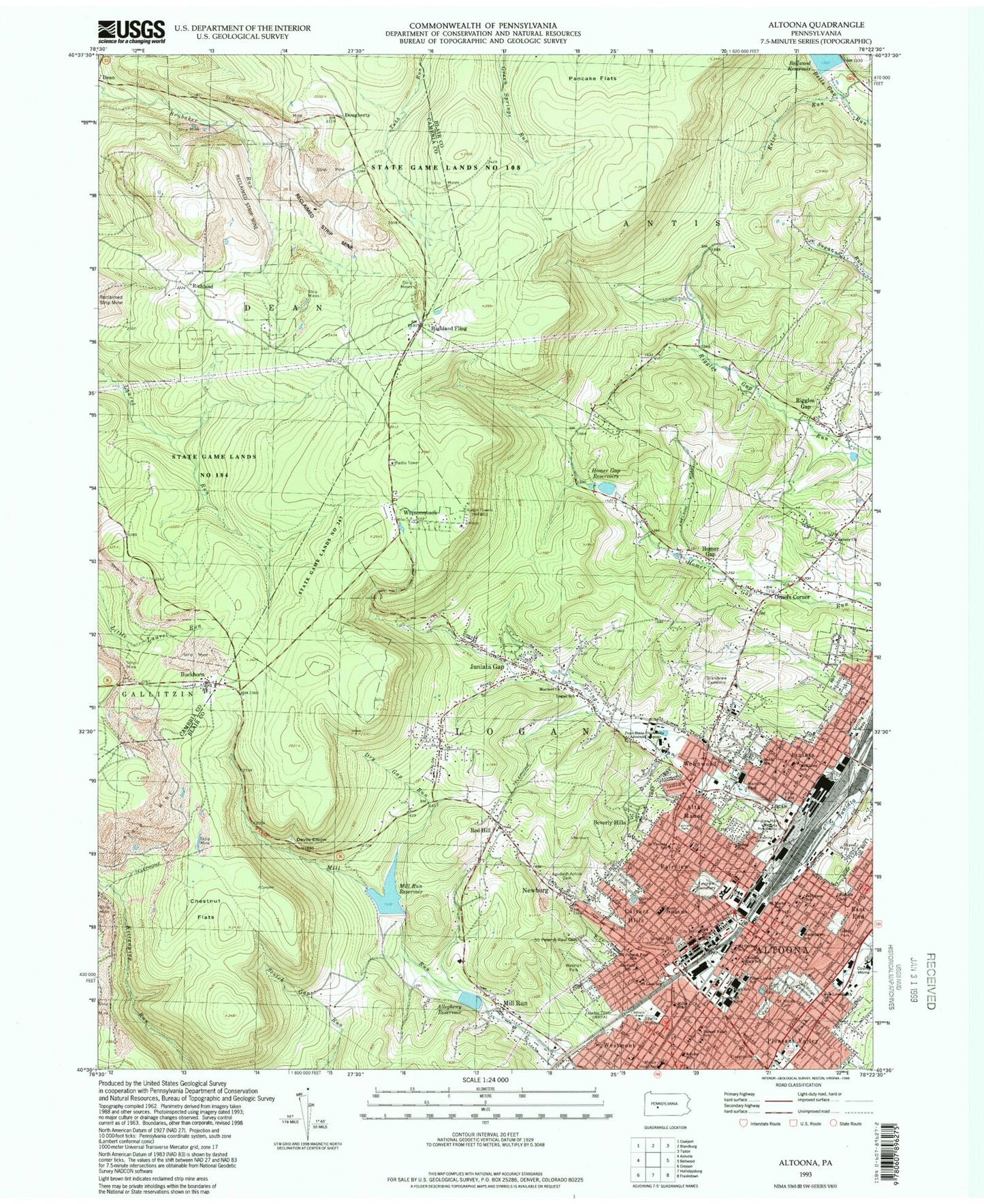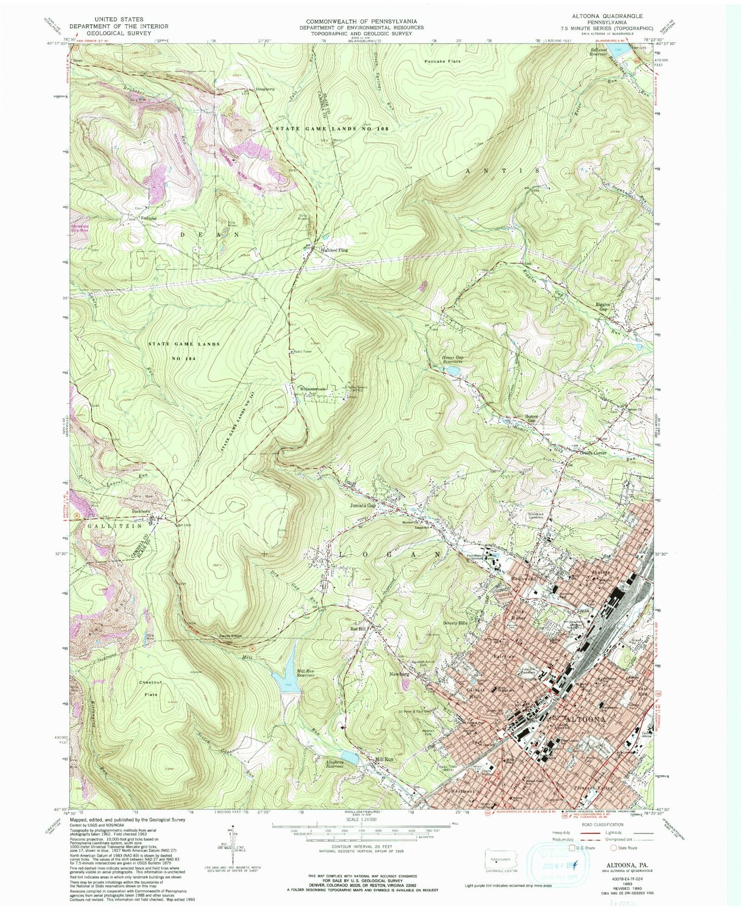
MyTopo
Classic USGS Altoona Pennsylvania 7.5'x7.5' Topo Map
Couldn't load pickup availability
Historical USGS topographic quad map of Altoona in the state of Pennsylvania. Typical map scale is 1:24,000, but may vary for certain years, if available. Print size: 24" x 27"
This quadrangle is in the following counties: Blair, Cambria.
The map contains contour lines, roads, rivers, towns, and lakes. Printed on high-quality waterproof paper with UV fade-resistant inks, and shipped rolled.
Contains the following named places: Adams School, Agudath Achim Cemetery, Allegheny Reservoir, Alta Manor, Beverly Hills, Buckhorn, Calvert Hills, Catholic High School, Chestnut Flats, Devils Elbow, Dry Gap Run, East End, Fairview, Fairview Cemetery, Fairview Park, Garfield School, Geesey Park, Gospel Hill Park, Grandview Cemetery, Homer Gap, Homer Gap Reservoir, Jefferson School, Juniata, Juniata Gap, Keith Junior High School, Kelso Run, Kettle Creek, Logan School, Lowell School, Mardorf Church, McKinley School, Memorial Park, Altoona Regional Health System Bon Secours (historical), Mill Run, Mill Run Reservoir, Miller School, Mount Carmel School, Newburg, Noble School, Oak Ridge Cemetery, Oakton Reservoir, Pancake Flats, Penn State University, Pleasant Valley, Prospect Park, Riggles Gap, Roosevelt Junior High School, Sacred Heart School, Saint Leos School, Saint Marks School, Saint Marys Cemetery, Saint Peter, Saint Theresa School, Saints Peter And Paul Roman Catholic Cemetery, State Game Lands Number 184, Stevens School, View Field, Wehnwood, Westfall Park, Westmont, Wopsononock, Altoona, Storage Dam, Mill Run Dam, Altoona Lower Number Two Dam, Kittanning Run, WFBG-FM (Altoona), WHGM-FM (Bellwood), WRTA-AM (Altoona), WTAJ-TV (Altoona), WOPC-TV (Altoona), Riggles Gap School (historical), McKnight School, Martz School, Coleman School (historical), Richland School, Pleasant Hill School (historical), Wopsononock Lookout, Dougherty, Highland Fling, Orners Corner, Richland, Pleasant Valley Shopping Center, Station Mall, Altoona Area High School, Highland Fling Tavern, State Game Lands Number 267, Fairview Park, Spring Run, Asbury Church, SS Peter and Paul School, Washington School, County Home, Jaffa Mosque, Penn-Lincoln School, Red Hill, Irving Elementary School, Washington Jefferson Elementary School, Spring Run, City of Altoona, Township of Logan, Township of Dean, Vicars Private Airport, Altoona Fire Department Headquarters Station 310, Newburg Fire Department Station 12, Altoona Fire Department Station 320, Logan Township United Fire Department Station 18, Altoona Fire Department Station 330, Marauders Run, Altoona Center, UPMC Altoona - Medical Center, Altoona Mobile Emergency Department Authority Headquarters, Altoona Post Office, Asbury United Methodist Cemetery, Cathedral of the Blessed Sacrament Crypt, Collinsville Cemetery, Colyer Cemetery, Eastern Light Cemetery, Hoffs Cemetery, Mount Sinai Cemetery, Saint Johns Cemetery, Saints Peter and Paul Russian Orthodox Cemetery, Saint Mary Ukrainian Catholic Cemetery, Altoona Police Department, Richland Methodist Cemetery, Juniata Gap Census Designated Place, Mill Run Census Designated Place, Newburg Census Designated Place, Red Hill Census Designated Place, Red Hill, Wopsononock Census Designated Place