
MyTopo
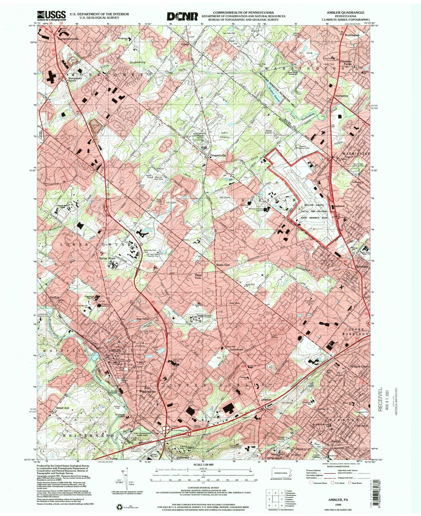
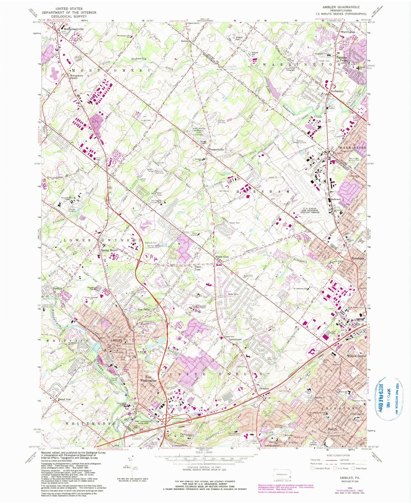
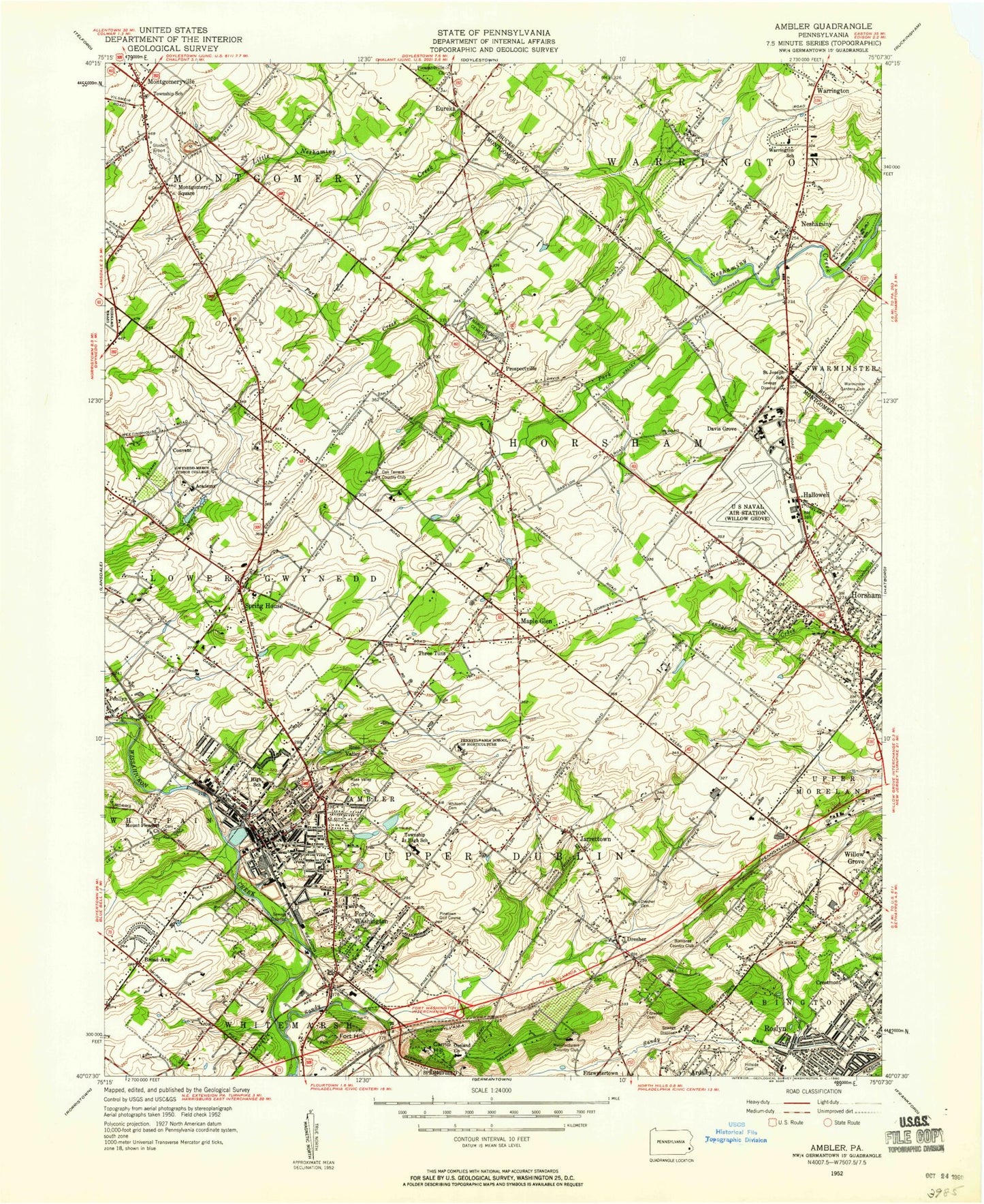
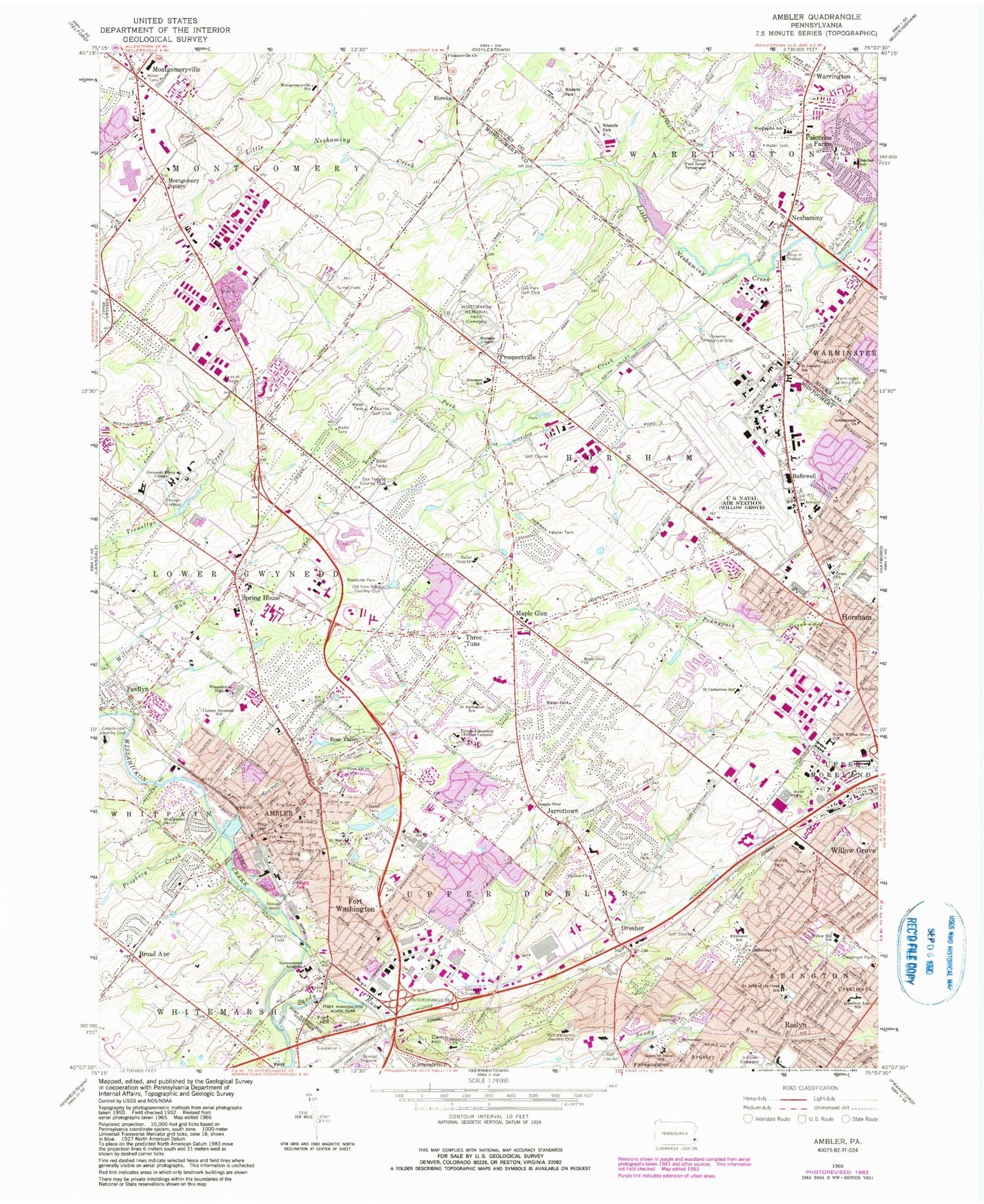
Classic USGS Ambler Pennsylvania 7.5'x7.5' Topo Map
Couldn't load pickup availability
Historical USGS topographic quad map of Ambler in the state of Pennsylvania. Typical map scale is 1:24,000, but may vary for certain years, if available. Print size: 24" x 27"
This quadrangle is in the following counties: Bucks, Montgomery.
The map contains contour lines, roads, rivers, towns, and lakes. Printed on high-quality waterproof paper with UV fade-resistant inks, and shipped rolled.
Contains the following named places: Ambler, Barclay School, Broad Axe, Camp Hill, Chelton Church, Crestmont Park, Dufur Hospital, Fairview Cemetery, Fort Hill, Fort Washington, Fort Washington State Park, Free Church, Germantown Academy, Grace Church, Gwynedd-Mercy College, Hallowell, Hamilton Avenue School (historical), Horsham, Lair Park, Lower Gwynedd School, Maple Glen, Maple Glen Church, Montgomery Square, Montgomeryville, Montgomeryville School, Mount Pleasant Church, Neshaminy, North Willow Grove School (historical), Limekiln Golf Course, Talamore Country Club, Oreland Church, Palomino Farms, Park Creek, Penllyn, Pickering Field, Pleasantville Church, Prophecy Creek, Prospectville, Queen of Peace School, Reformed Church, Rose Hill Cemetery, Rose Valley Cemetery, Saint Alphonsus School, Saint Catherine of Siena School, Saint John of the Cross School, Saint Josephs School, Saint Marys School, Saint Pauls Church, Saint Pauls Church, Sandy Run, Spring House, Temple Sinai, Three Tuns, Trinity Church, Pine Grove Memorial Park, Wayside Chapel, Willow Run, Willett Park, Willow Hill School, Wissahickon High School, Crestmont, Roslyn, Temple University, Rorer Group Airport, Asplundh Airport (historical), Prudential Business Campus Airport (historical), Keystone Helicopter Corp/Toll Brothers Airport (historical), Horsham Valley Golf Course Airport (historical), Melville Airport (historical), Horsham Township Police Airport (historical), Turner Field (historical), Copter-Barness Airport (historical), Kenas Airport (historical), Whisper Pines Airport (historical), Montgomeryville Airport (historical), Lock Alsh Reservoir, Lock Alsh Reservoir Dam, Neshaminy SCS Dam 611, Warrington Township Retention Basin Dam, Davis Grove, Florence D Titus Elementary School, Long Dam, Taylor Dam, Cornog Dam, Mehler Dam, Pine Run, Fairoaks, The Woods, Tannerie Woods, Windsor Pass, Dreshertowne, The Meadows, The Woodlands, Saw Mill Valley, Wynmere Downs, Georgetown of Philadelphia, Meadows at Lower Gwynedd, Willowmere, Mount Pleasant, Dresher, Eureka, Jarrettown, Rose Valley, Upper Dublin High School, Hatboro-Horsham Senior High School, Hidden Springs Golf Course, Twining Golf Course, Montgomeryville Mall, Twining Valley Golf Course, Montgomery Mall, Pinetown, Horsham Valley Township Park, Horsham Valley Industrial Park, Babylon Industrial Complex, Keith Valley Middle School, Horsham Ridge Industrial Center, Prudential Business Campus, Spring House Shopping Center, Graeme State Park, Cheston Robbins Park, Ambler Church of the Brethren, Paul Valley Industrial Park, Saint Josephs Catholic Church, Willow Farms, Warrington Industrial Park, Neshaminy Gardens, Warrington Mews Pavilion Shopping Center, Hampton Greens, Fairways, Warrington Village, Fairway Golf Course, Wright Dam, Dager Dam, Worthington Dam, McKean Dam, Hoopes Dam, Rittenhouse Dam, Keasby Mattison Dam, Foedisch Dam, Craft Dam, Thompson Dam, Lock Linden Dam, Lock Alsh Dam, Horsham Valley Golf Course, Hallowell Elementary School, English Village Shopping Center, Warrington Plaza, Cedarbrook Country Club, Graeme (historical), Manufacturers Country Club, Old York Road Country Club, Squires Golf Club, Whitemarsh Memorial Park, Thomas Fitzwater Elementary School, Simmons Elementary School, Roslyn Elementary School, Warrington, Borough of Ambler, Township of Warrington, Township of Horsham, Township of Lower Gwynedd, Township of Montgomery, Township of Upper Dublin, Bradford Reservoir, Bradford Reservoir Recreation Area, Twin Oaks Park, Upper Nike Park, Lower Nike Park, Fort Washington Elementary School, Mattison Avenue Elementary School, Wissahickon Middle School, Limekiln-Simmons School, Maple Glen Elementary School, Three Tuns Junior High School (historical), Jarrettown Elementary School, Warrington Fellowship Church, Annunciation Hall, Assumption Hall, Bryne Hall, Connelly Faculty Center, Fatima Hall, Genuardi Pool and Pavillion, Gustav Martin Hall, Julia Ball Auditorium and Lobby, Keiss Hall, Lady Garden, Lourdes Library, McAuley Center, Residence Hall Complex, Tabor Hall, The Griffin Complex, Transfiguration Convent, Trocaire, Waldron Center, Bethleham Pike Industrial Park, Broad Axe Village, Cloverly Farms, Fire Department of Montgomery Township Battalion 1, Commonwealth Corporate Center, Commonwealth National Country Club, Burn Brae Park, Canterbury Corporate Center, Carl Kohler Park, Carpenters Way, Cedar Hill Road Park, Cheston-Robbins Park, Childventure Museum, 537 Horsham Plaza Shopping Center, Ambler Borough Hall, Ambler City Park, Ambler House, Ambler Police Station, Ambler Post Office, Ambler Station, Arbor Glen, Babylon Business Center, Gwynmont Farms, Gwynn Oaks, Hampton Green, Henry Lee Willett Park, Hideaway Hills Park, Holy Word Lutheran Church, Horsham Bible Church, Horsham Business Center, Horsham Chamber of Commerce, Horsham Chase, Horsham Clinic, Horsham Point Shopping Center, Horsham Post Office, Horsham Fire Company Station 15, Horsham Fire Company Station 15 - B, Horsham Terrace, Horsham Township Hall, Horsham Township Park, Horsham Township Police Station, Dawesfield