MyTopo
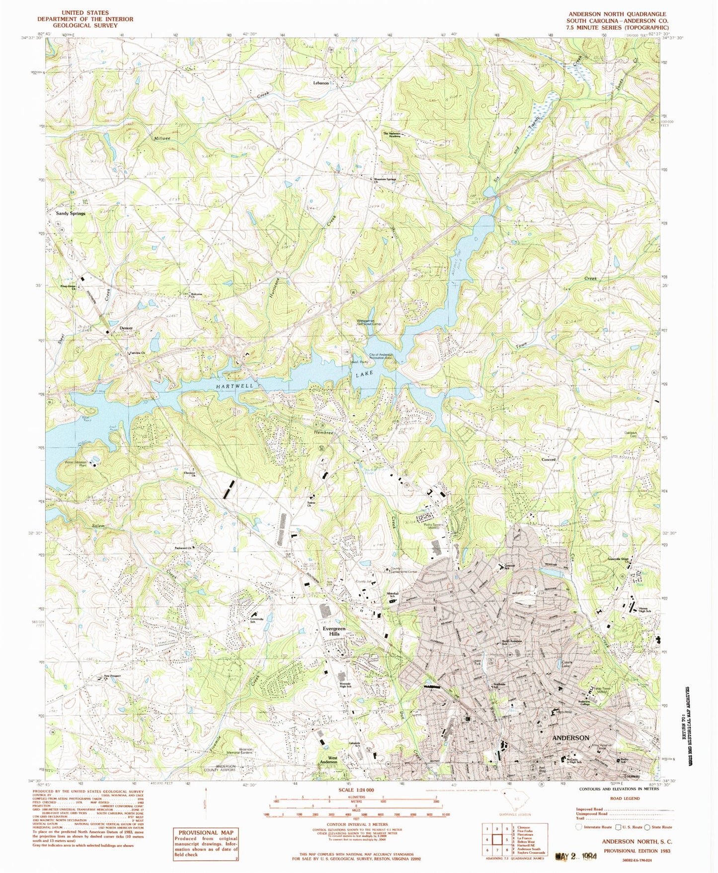
Classic USGS Anderson North South Carolina 7.5'x7.5' Topo Map
Couldn't load pickup availability
Historical USGS topographic quad map of Anderson North in the state of South Carolina. Map scale may vary for some years, but is generally around 1:24,000. Print size is approximately 24" x 27"
This quadrangle is in the following counties: Anderson.
The map contains contour lines, roads, rivers, towns, and lakes. Printed on high-quality waterproof paper with UV fade-resistant inks, and shipped rolled.
Contains the following named places: Abiding Savior Lutheran Church, Abney Mills Park, Allen Hills, Anderson, Anderson City Fire Department Station 1, Anderson City Fire Department Station 2, Anderson City Fire Department Station 3, Anderson City Hall, Anderson College, Anderson College Library, Anderson County, Anderson County Courthouse, Anderson County Fire Department Sandy Springs Station 26, Anderson County Fire Hopewell Fire Department, Anderson County Health Center, Anderson County Jail, Anderson County Library, Anderson Downtown Historic District, Anderson First Presbyterian Graveyard, Anderson Mall Shopping Center, Anderson Memorial Gardens, Anderson Memorial Hospital, Anderson Police Department, Anderson Post Office, Anderson Village, AnMed Health Medical Center, AnMed Health Medicus Surgery Center, AnMed Health North Campus, AnMed Health Rehabilitation Hospital, Asbury Memorial Baptist Church, Ashley Downs, Assembly Apostolic Church, Autumn Oaks, Bailey School, Belvedere Plaza Shopping Center, Bethel Methodist Cemetery, Bethel Methodist Church, Boulevard Baptist Church, Bridlewood, Brittany Park, Brook Hollow, Brookview Park, Calhoun Street Elementary School, Calvary Baptist Church, Cambridge Place, Camp Shopping Center, Cardinal Park, Carnegie Library, Carter Hall, Cater Lake Park, Cater Park, Cedarwood, Centerville, Centerville Baptist Church, Centerville Census Designated Place, Centerville Church of God, Centerville School, Centerville Terrace Estates, Centerville Volunteer Fire Department, Central Baptist Church, Central Presbyterian Church, Chateau Woods, Church of God, Church of the Nazarene, City of Anderson, City of Anderson Recreation Area, Clarendon, Clearview, Coleman Municipal Recreation Center, Colonial Hills, Colony Hill, Concord, Concord Baptist Church Graveyard, Concord School, Cornerstone Assembly of God Church, Denver, Denver Recreation Area, Dickerson Acres, District 5 Stadium, Dogwood Heights, Dunhill, Ebenezer School, Englewood, Equinox Park, Evergreen Hills, Fairview Church, Fieldcrest Acres, First Baptist Church, First Presbyterian Church, Forest Park, Forrest College, Franklin Place, Fullers Chapel Holiness Church, Galloway Park, Garner Memorial Baptist Church, Gilmer Estates, Girls High School, Glenn Street School, Green Forest, Green Hill Plantation, Greenville Street Church, Hanna High School, Hanover, Harpers Ridge, Harvest Baptist Church, Hembree Creek, Heritage Hills, Heritage Trace, Hill and Dale, Holly Creek, Holly Springs Church, Holy Trinity Lutheran Church, Honea Path Park, Hopewell School, House of Prayer, Hunters Trail, Huntington Hills, Hurricane Creek, Iola Post Office, Jefferson Avenue Grade School, Jefferson Avenue Park, Jim Rice Park, Jones Creek, Kingdom Hall of Jehovahs Witnesses, Kings Court, Kingsley Hills, Kingswood Terrace, Knoxwood, Lake Huntington, Lakeside, Lakeside Mall Shopping Center, Lakeside Middle School, Lakewood, Lebanon, Lebanon Baptist Church, Lebanon School, Leeward Landing, Lexington Place, Linley Park, Loblolly Pines, Market Place Shopping Center, McCants Junior High School, McDuffie Street Church of God, McGee Acres, Meadowbrook Heights, Medshore Ambulance Service, Melbourne Heights, Middleton Shores, Miracle Mile Shopping Center, Mount Vernon, Mountain Spring Baptist Church Graveyard, Mountain Springs School, New Prospect Baptist Church Graveyard, New Prospect Elementary School, New Prospect Estates, New Salem, North Anderson Park, North Anderson School, North Fant Street School, North Forest Estates, North Forks, Northlake, Northlake Census Designated Place, Northside School, Northview, Oaklawn Cemetery, Oakwood Baptist Church, Oakwood Estates, Old Welcome Baptist Church Graveyard, Park Place, Parkwood, Parkwood Baptist Church, Physician Surgery Center at AnMed Health, Pine Acres, Piney Grove School, Pineygrove Baptist Church, Pope Drive Baptist Church, Pruitt Shopping Center, Quail Hollow, Ranken Pond Dam D-3265, Regency Park, Regency Woods, Rosehill Museum, Saint Josephs Catholic Church, Saint Josephs School, Saint Marys Hospital, San Mateo, Sandy Springs, Sandy Springs Census Designated Place, Sedgefield, Sherwood Forest, Smith School, South Carolina Noname 04018 D-3107 Dam, South Carolina Noname 04019 Dam, South Carolina Noname 04027 D-3122 Dam, Spring Park, Stonehaven, Stonewall Woods, Stratford Terrace, Summer Place, Sunnyside Acres, Sweet Gum Trail, Taylor Memorial Pentecostal Holiness Church, Temple Baptist Church, The Anderson Academy, Town Creek, Towne Center Shopping Center, Towne Creek Acres, Toxaway Park, Trinity Baptist Church, Trinity Cemetery, Trinity Church, Twin Lakes, Upstate Endoscopy Center, WANS-AM (Anderson), Watson Estates, Waverly Square, Welcome, Welcome Baptist Church, West Anderson, West Anderson Church of God, West Market Street Graded School, West Whitner Baptist Church, Westside High School, White Hall School, Whitehall Elementary School, Whitehall Park, Whitehall Shopping Center, Williamsburg Manor, Wilson Calvary Baptist Church, Windsor Place, Wistagaman Girl Scout Camp, Woodbridge, Young Memorial Associate Reformed Presbyterian Church, Zion Church of God Holiness