
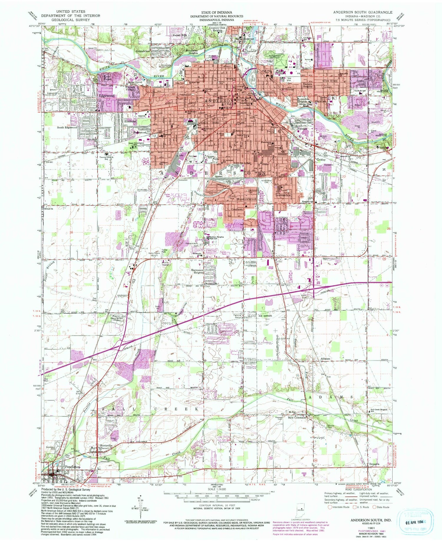
MyTopo
Classic USGS Anderson South Indiana 7.5'x7.5' Topo Map
Couldn't load pickup availability
Historical USGS topographic quad map of Anderson South in the state of Indiana. Typical map scale is 1:24,000, but may vary for certain years, if available. Print size: 24" x 27"
This quadrangle is in the following counties: Madison.
The map contains contour lines, roads, rivers, towns, and lakes. Printed on high-quality waterproof paper with UV fade-resistant inks, and shipped rolled.
Contains the following named places: Alliance, Anderson, Anderson Memorial Park, Belmont Church, Bethel Church, Bucco Cemetery, Brentwood, Central Avenue School, Circle Park, Columbia School, Country Club Heights, Crestlawn, Denny Field, East Side Church, Eastern Heights, Edgewater Park, Edgewood, Eldorado School, Elmhurst, Emporia, Extension Heights, Fairfax, Fairfax Church, Fairview Park, Fall Creek Heights School, Falls Park, Forest Hills, Franklin Elementary School, Gilmore Cemetery, Glyn Ellen, Grandview, Great Commission School, Gridley, Grove Lawn Cemetery, Harmeson Heights, Highland Senior High School, Hillcrest, Horne Park, Hubbard Park, Huntsville, Irondale, Killbuck Creek, Lindberg School, Longfellow School, Lowmandale, Madison Heights High School, Madison Park, Maplewood Cemetery, Meadowbrook, Meadowbrook Park, Michael Ditch, Moss Cemetery, Mounds Church, Mount Zion Church, New Columbus, Orebaugh Ditch, Park Place Elementary School, Park Road Church, Pee Wee Cemetery, Pittsford Ditch, Waggy Cemetery, Prairie Creek, Puiaski Park, Riley Park, Riley School, River Forest, Roosevelt School, Saint Ambrose School, Saint Marys Cemetery, Saint Marys School, Seventh Street School, Shadeland Elementary School, South Edgewood, South Side Middle School, Spring Branch, Stanley Ditch, Stanton Park, Sugar Fork, Tenth Street Elementary School, Twenty-Fifth Street Elementary School, Vandeventer Cemetery, Washington School, West Maplewood Cemetery, Western Village, Westvale Elementary School, Whetstone Church, White River Bluff, Woodlawn Heights, Edgewood Elementary School, Anderson High School, Meadowbrook Elementary School, WHBU-AM (Anderson), WHUT-AM (Anderson), WLHN-FM (Anderson), Ace Airpark (historical), Rolling Hills Convalescent Center Airport (historical), Anderson University, Edgewood Country Club, Grandview Country Club, Township of Anderson, City of Anderson, Town of Country Club Heights, Town of River Forest, Town of Edgewood, Town of Woodlawn Heights, Pendleton Fire Department, Anderson Fire Department Station 1 Headquarters, Edgewood Fire Department, Anderson Fire Department Station 6, Anderson Fire Department Station 2, Anderson Fire Department Station 3, Anderson Fire Department Station 8, Anderson Fire Department Station 7, Pendleton Quarry, Saint Vincent Anderson Hospital, Anderson Fire Department, Emergency Medical Ambulance Service of Madison County, Pendleton Emergency Ambulance Service, Edgewood Police Department, Anderson Police Department, Pendleton Police Department, Madison County Sheriff's Office, Anderson Post Office, Anderson Post Office, Pendleton Post Office, Mount Zion Lutheran Cemetery


