MyTopo
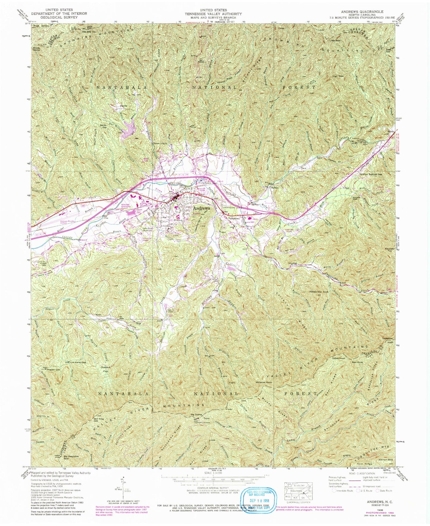
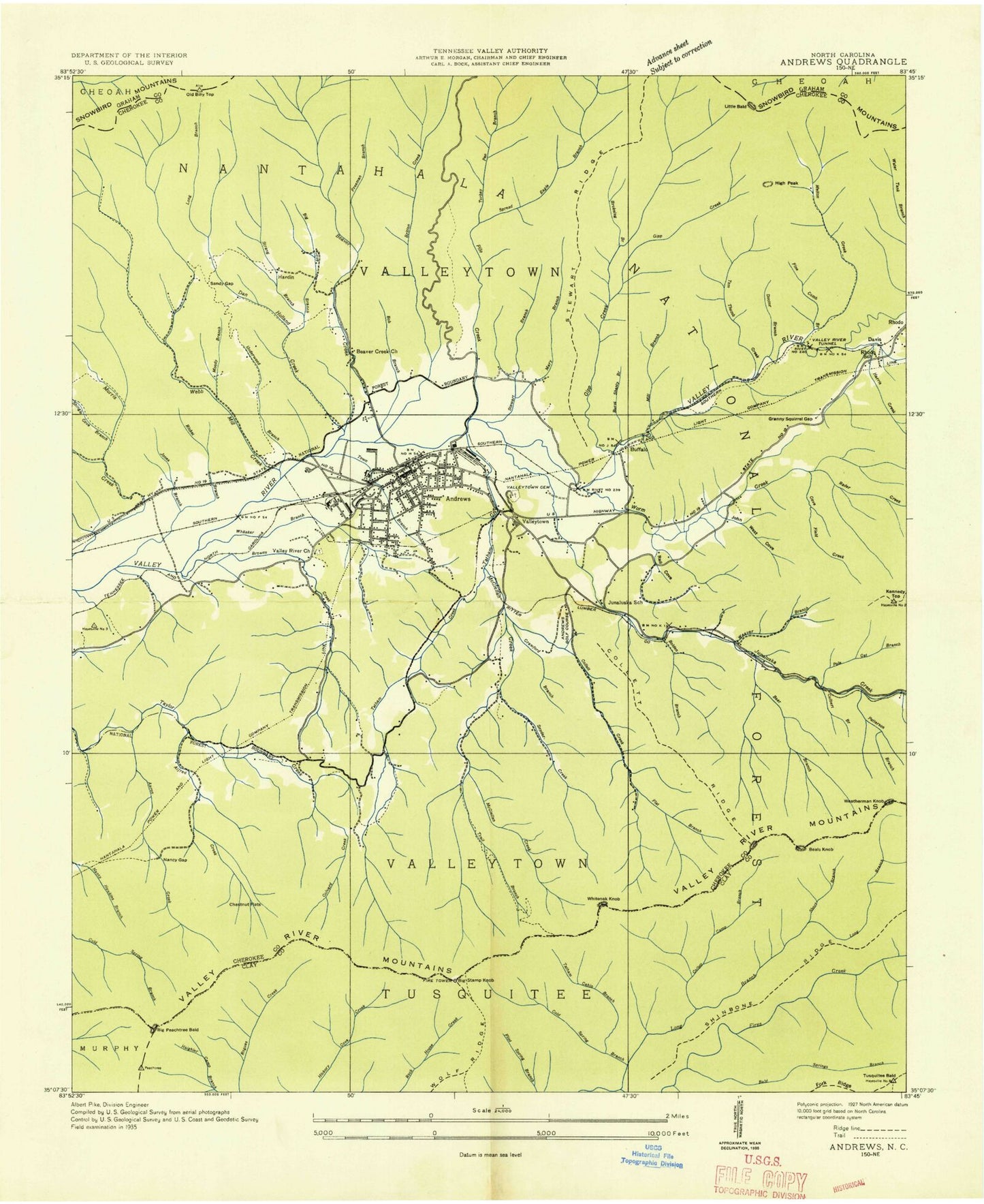
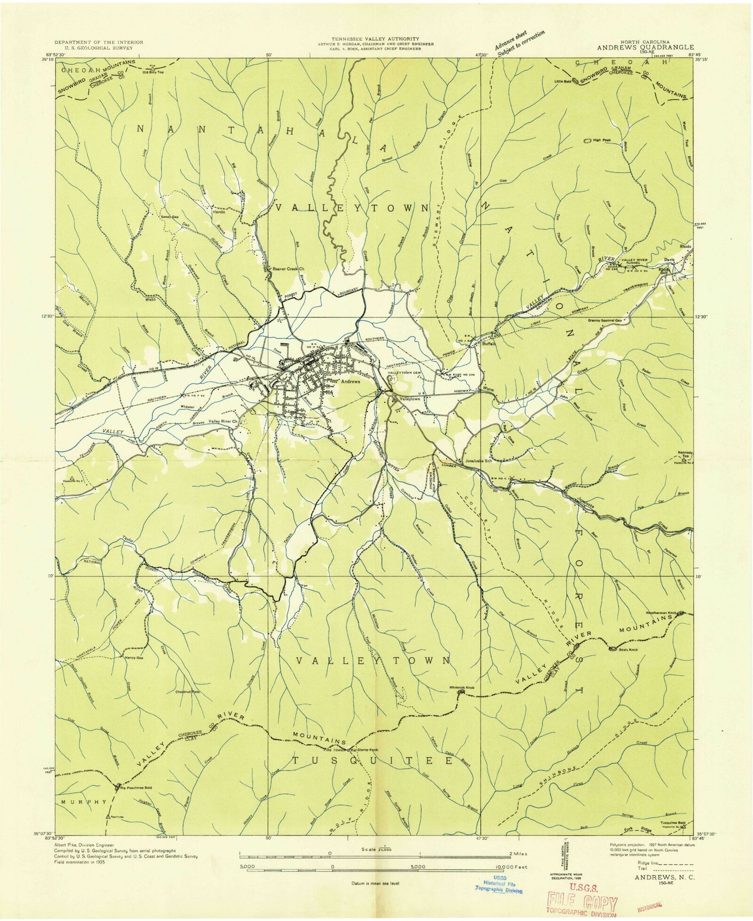
Classic USGS Andrews North Carolina 7.5'x7.5' Topo Map
Couldn't load pickup availability
Historical USGS topographic quad map of Andrews in the state of North Carolina. Typical map scale is 1:24,000, but may vary for certain years, if available. Print size: 24" x 27"
This quadrangle is in the following counties: Cherokee, Clay, Graham.
The map contains contour lines, roads, rivers, towns, and lakes. Printed on high-quality waterproof paper with UV fade-resistant inks, and shipped rolled.
Contains the following named places: Coefield Creek, Aaron Creek, Alfred Creek, Allmon Branch, Ash Cove, Ash Cove Creek, Bald Springs Branch, Beach Branch, Beal Ridge, Bear Branch, Beaver Creek, Beaver Creek Church, Big Cove, Big Cove Branch, Big Peachtree Bald, Big Stamp, Bob Branch, Bolden Branch, Britton Creek, Brokeleg Branch, Brown Creek, Brushy Ridge, Bryson Branch, Buckhorn Ridge, Burnt Shanty Branch, Chestnut Flats, Coefield Branch, Coldspring Branch, Collett Camp Branch, Collett Creek, Collett Ridge, Colvard Creek, Crawford Branch, Culbert Branch, Dan Holland Creek, Doctor Branch, Fine Comb Branch, Fires Creek Wildlife Management Area, Flat Branch, Flat Branch, Fork Ridge, Freeman Branch, Gipp Creek, Granny Squirrel Branch, Granny Squirrel Gap, Gumflats Creek, Harris Creek, Hogpen Branch, Hogpen Gap, Ingram Branch, John West Cove, Johnson Bald, Jones Branch, Junaluska Creek, Jutts Gap, Kennedy Creek, Kennedy Falls, Leatherwood Mountain, Left Fork Webb Creek, Long Branch, Mary Branch, Matherson Creek, Mc Clellan Creek, Melton Creek, Messer Branch, Mike Branch, Mill Branch, Moody Branch, Moody Stamp, Nancy Gap, Nick Branch, Old Billy Top, Patterson Branch, Phillips Creek, Phillips Ridge, Pile Creek, Polecat Branch, Polecat Branch, Potrock Branch, Puncheon Branch, Radder Creek, Rail Cove, Rail Cove Branch, Rattlesnake Knob, Ricket Branch, Right Fork Bear Branch, Right Fork Webb Creek, Rockhouse Ridge, Rogues Branch, Sandy Gap, Sassafras Ridge, Shop Branch, Short Branch, Snyder Creek, Spread Eagle Branch, Stewart Branch, Stewart Ridge, Stillhouse Branch, Strange Branch, Sunk Branch, Tatham Cabin Branch, Tatham Creek, Tom Thumb Creek, Town Branch, Trail Branch, Truett Branch, Turkeypen Branch, Turnpike Creek, Underwood Branch, Valley River Cemetery, Valley River Church, Valleytown Cemetery, Weaver Branch, Webb Creek, Whitaker Branch, Will King Gap, Wolf Ridge, Worm Creek, Western Carolina Regional Airport, Andrews Elementary School, Andrews High School, Andrews Plaza, Georgia State Prison Camp, Rhodo School, Little Peak, Janaluska School, Andrews, Beal Knob, Buffalo, Defeat Knob, Hardin, High Peak, Kennedy Top, Little Bald, Rhodo, Sassafras Knob, Valleytown, Whiteoak Knob, Township of Valleytown, Town of Andrews, Valleytown Volunteer Fire Department, Andrews Volunteer Fire Department, Cherokee County Emergency Medical Services Station 2, Andrews Rescue Squad, Andrews Post Office, Andrews Police Department