MyTopo
Classic USGS Argo Alabama 7.5'x7.5' Topo Map
Couldn't load pickup availability
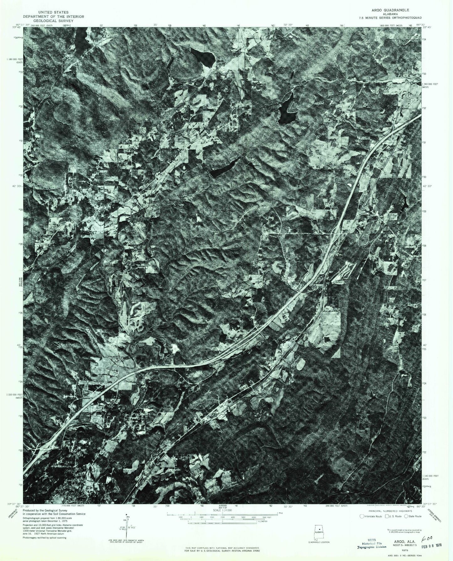
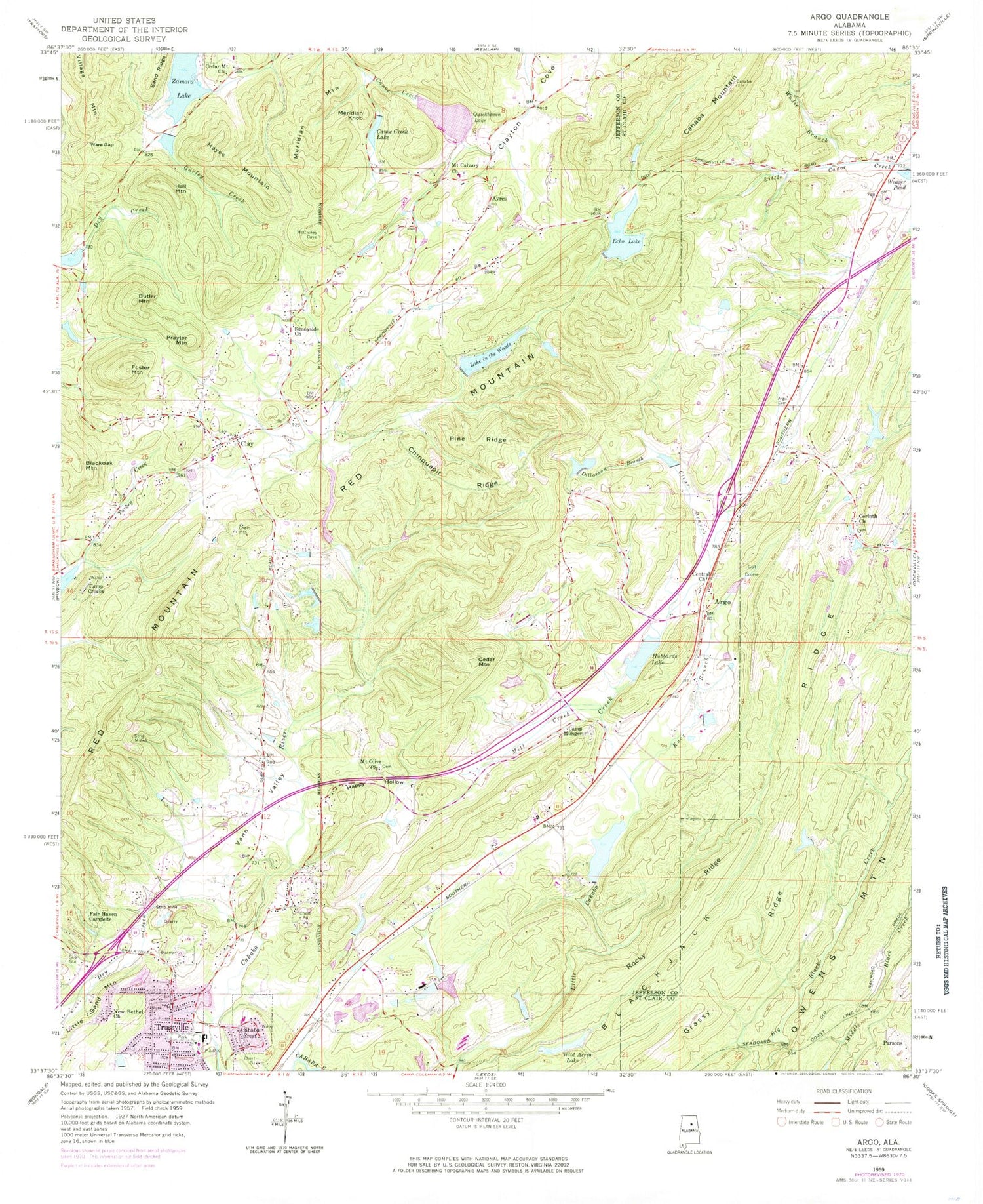
Historical USGS topographic quad map of Argo in the state of Alabama. Typical map scale is 1:24,000, but may vary for certain years, if available. Print size: 24" x 27"
This quadrangle is in the following counties: Jefferson, St. Clair.
The map contains contour lines, roads, rivers, towns, and lakes. Printed on high-quality waterproof paper with UV fade-resistant inks, and shipped rolled.
Contains the following named places: Black Oak Mountain, Butler Mountain, Cahaba Crest, Camp Munger, Canoe Creek Lake, Central Church, Chinquapir Ridge, Clay, Clear Branch, Dillashaw Branch, Dry Creek, Echo Lake, Fair Haven Campsite, Foster Mountain, Hall Mountain, Happy Hollow, Hayes Mountain, Hubbards Lake, Meridian Knob, Mount Olive Baptist Church, New Bethel Church, Pine Ridge, Praytor Mountain, Sunnyside Church, Ware Gap, Wild Acres Lake, Lake in the Woods, Wild Acres Lake Dam, Windsong Lake Dam, Riggins Pond Dam, Riggins Pond, Holcomb Lake, Little Cahaba Creek Lake Dam, Hubbards Lake Dam, J M Roberts Pond Dam, J M Roberts Pond, Old Camp Cosby Lake, Cahaba River Lake Dam, Hidden Valley Lake, Lake in the Woods Dam, Echo Lake Dam, Hilldale Farm Lake Dam, Quickhaven Lake Dam, Zamora Park Lake, Sunnyside, Vanns, Vann Valley Assembly of God Church, Windsong Lake, Zamora Park, Argo Church, Argo Station (historical), Ayres Estates, Bethel Church, Breakstone Village, Circle Three Lakes, Clay Alliance Church, Clay Baptist Church, Clay Elementary School, Clay School (historical), Emerald Valley Resort, Glendale Farms, Hewitt Elementary School, Hewitt-Trussville High School, Hewitt-Trussville Junior High School, Hilldale Farm Lake, Lacy Buke Furnace (historical), Liles Lake, Meadow Run Country Club, Mount Canana Church, Riverview Church, Mount Calvary Cemetery, Wilkes (historical), East Trussville (historical), Lawless Gap, Worthington Ore Mines, Cahaba Village, Vann Quarry, Cedar Mount Baptist Church, Cedar Mountain, Meridian Mountain, Mill Creek, Mount Calvary Presbyterian Church, Quickhaven Lake, Vann Valley, Clay Methodist Church, Argo, Ayres, Reid Spring, Argo Cemetery, Blackjack Ridge, Cahaba Mountain, Corinth Church, Knox Branch, Owens Mountain, Parsons, Rocky Ridge, Wadie Branch, Weaver Pond, Wilborn Lake, Watkins Dam, Minith Dam, Minith Lake, Tadpole Dam, Tadpole Lake, Argo Church, Misty Pines, Reids School (historical), Clay Division, Candlewood Lakes, Clay Post Office, Confederate Estates, Cotton Ridge, Countryside Estates, Dogwood Estates, Eagle Ridge, Echo Hills, Meadowview Estates, Moss Rock, Near Acres Estates, Roddams Trailer Park, Rolling Hills, Saddlewood, Sherman Oaks, Southern Acres, West Ridge, Woodward, Argo Town Hall, City of Clay, Town of Argo, City of Trussville, Clay First Assembly of God Church, Trussville Fire and Rescue Service Station 3, Argo Fire and Rescue Station 1, Argo Fire and Rescue, Center Point Fire District Station 4