MyTopo
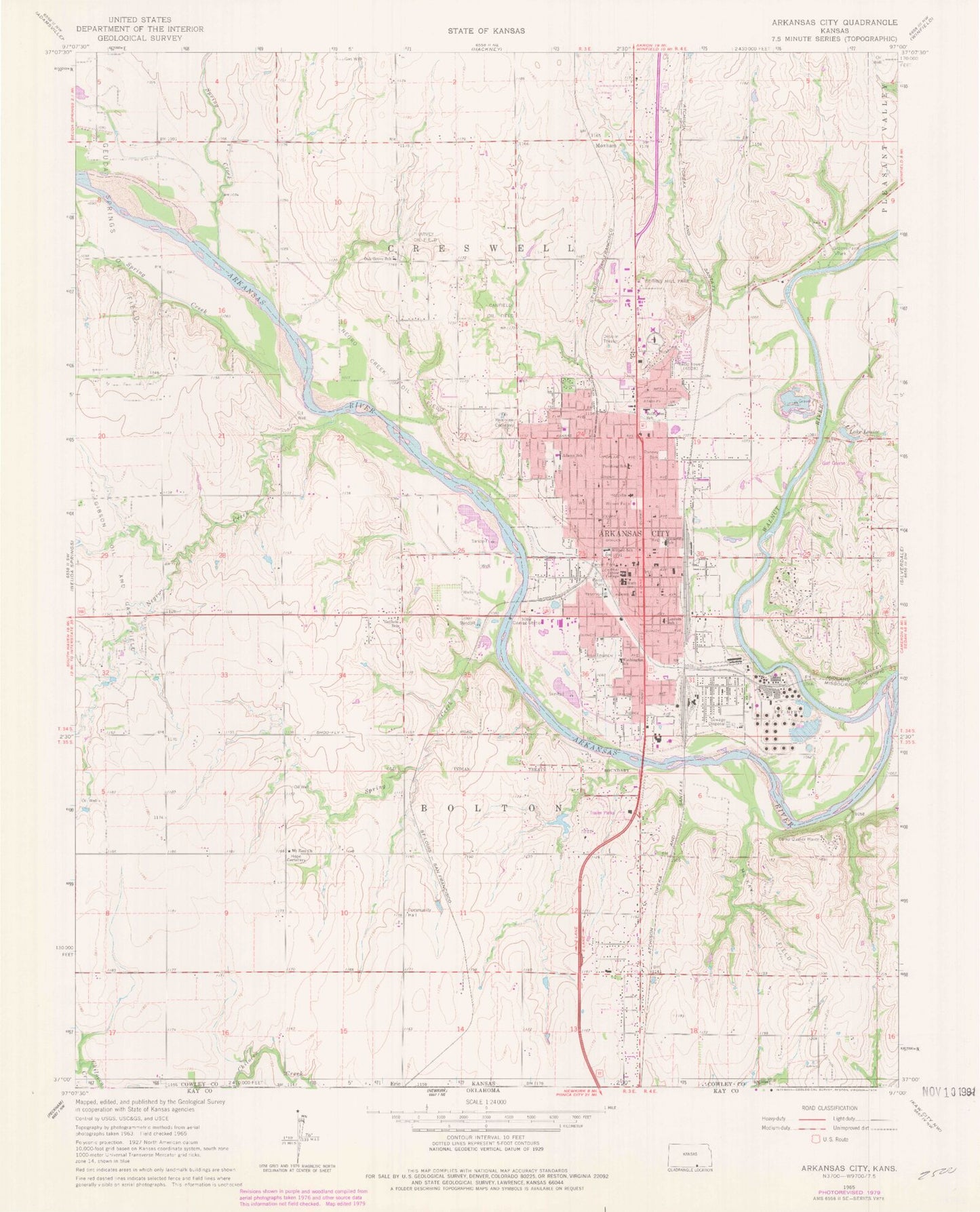
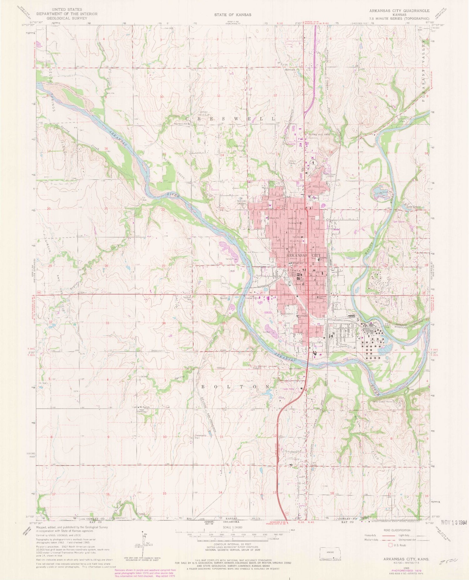
Classic USGS Arkansas City Kansas 7.5'x7.5' Topo Map
Couldn't load pickup availability
Historical USGS topographic quad map of Arkansas City in the state of Kansas. Map scale may vary for some years, but is generally around 1:24,000. Print size is approximately 24" x 27"
This quadrangle is in the following counties: Cowley.
The map contains contour lines, roads, rivers, towns, and lakes. Printed on high-quality waterproof paper with UV fade-resistant inks, and shipped rolled.
Contains the following named places: Adams Elementary School, Ark City Christian Academy, Arkansas City, Arkansas City Area Chamber of Commerce, Arkansas City Church of Christ, Arkansas City Church of the Nazarene, Arkansas City Country Club, Arkansas City Fire / EMS Department, Arkansas City Friends Church, Arkansas City Hall, Arkansas City High School, Arkansas City Middle School, Arkansas City Missionary Baptist Church, Arkansas City Municipal Wastewater Treatment Plant, Arkansas City Police Department, Arkansas City Post Office, Arkansas City Public Library, Arkansas City Recreation Center, Arkansas City Senior Center, Bible Christian Church, Bland School, Blessing Heights Church of God of the Apostolic Faith, Burlington Northern Santa Fe Arkansas City Railyard, Cale, Calvary Chapel, Camp Quaker Haven, Canfield Oil Field, Carver Park, Central Christian Church, Cherokee Strip Land Rush Museum, Church of God in Christ, City of Arkansas City, Cowley College, Cowley College Brown Center, Cowley College Galle Johnson Hall, Cowley College Ireland Hall, Cowley College Kerr Center, Cowley College Nelson Student Center, Cowley College Walker Industrial Technology Building, Cowley College Webb - Brown Building, Cowley College Wellness Center, Cowley County Community College Central Avenue Dormitory, Cowley County Community College D Robert Storbeck Dormitory, Cowley County Community College Kirke W Dale Dormitory, Cowley County Community College Oscar Kimmell Dormitory, Cowley County Community College Recreation Building, Cowley County Community College Renn Memorial Library, Cowley County Community College W S Scott Auditorium, Cowley County Community College William R Docking Dormitory, First American Baptist Church, First Assembly of God Church, First Church of Christ Scientist, First Presbyterian Church, First Southern Baptist Church, First United Methodist Church, First United Pentecostal Church, Frances Willard Elementary School, Geuda Springs Oil Field, Gibson Oil and Gas Field, Glorious Victory Worship Center, Goff Industrial Park, Gospel Light Church, Greens Farm Park, Guthrie School, Haines Landing Field, Harvest Fellowship Foursquare Church, Harvey Oil Field, Holiness Church of God, Hope Cemetery, IXL Elementary School, Jefferson Elementary School, Kaw Wildlife Area, KSOK-AM (Arkansas City), Lake Louise, Lincoln Early Childhood Center, McKay Oil Field, Mercer School, Mount Zion Church, Moxham, Negro Creek, Negro Creek Oil Field, New Hope Assembly Pentecostal Church, New Life Fellowship Church, Northside Baptist Church, Oak Grove School, Paris Park, Pershing Elementary School, Pilgrim Rest Baptist Church, Random Road Community Church, Ranney Park, Redeemer Lutheran Church, Redwood Village Shopping Center, Riverview Cemetery, Roosevelt Elementary School, Sacred Heart Catholic Church, Sacred Heart Catholic School, Saint James African Methodist Episcopal Church, Saint Paul United Methodist Church, Sandalwood Mobile Home Park, Spring Creek, Spring Hill Golf Course, Spring Hill Park, Sunflower Mobile Home Estates, T G AND Y Family Center, The Church of Jesus Christ of Latter Day Saints, Township of Bolton, Township of Creswell, Trinity Baptist Church, Trinity Episcopal Church, Vinelife Family Church, Walnut River, Washington Elementary School, Willow Creek Mobile Home Park, Wilson Park