MyTopo
Classic USGS Ashburnham Massachusetts 7.5'x7.5' Topo Map
Couldn't load pickup availability
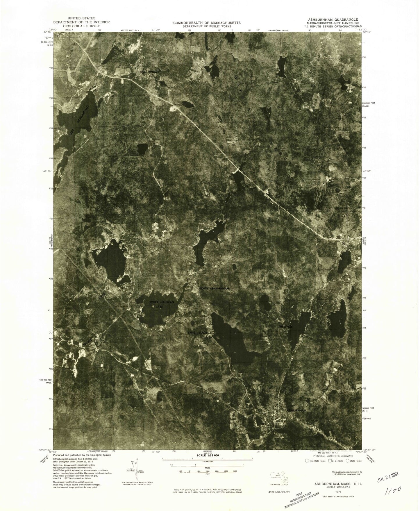
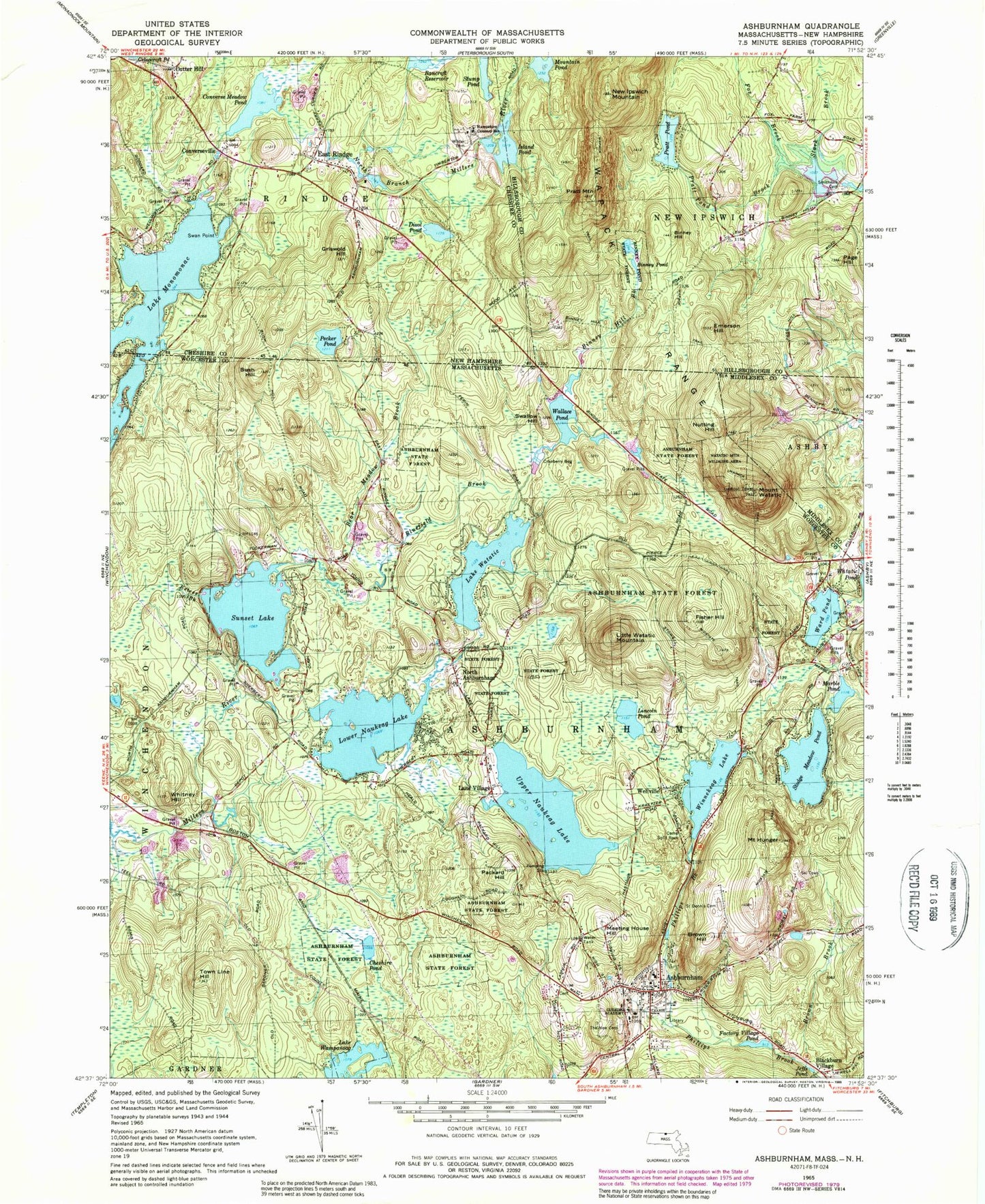
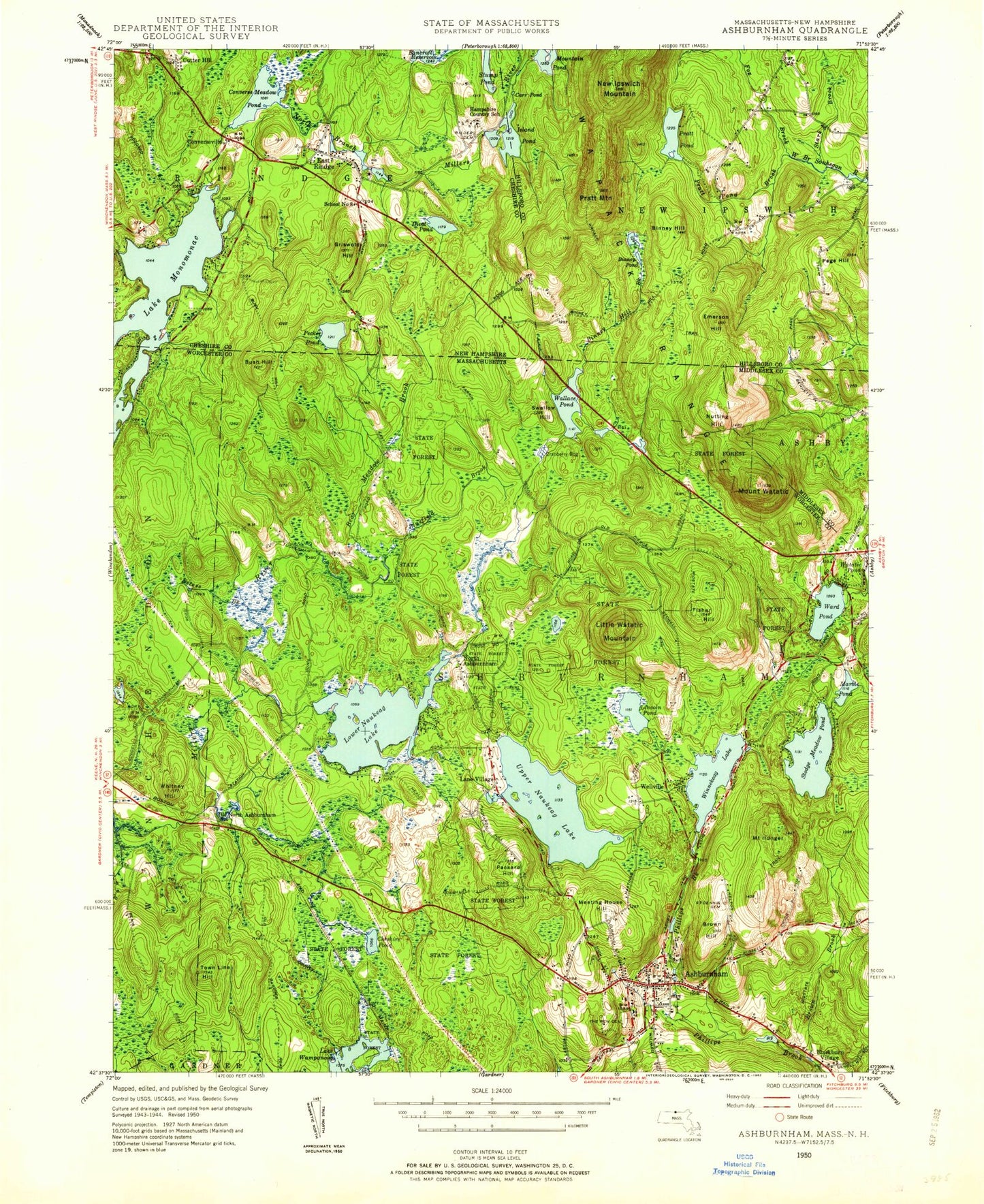
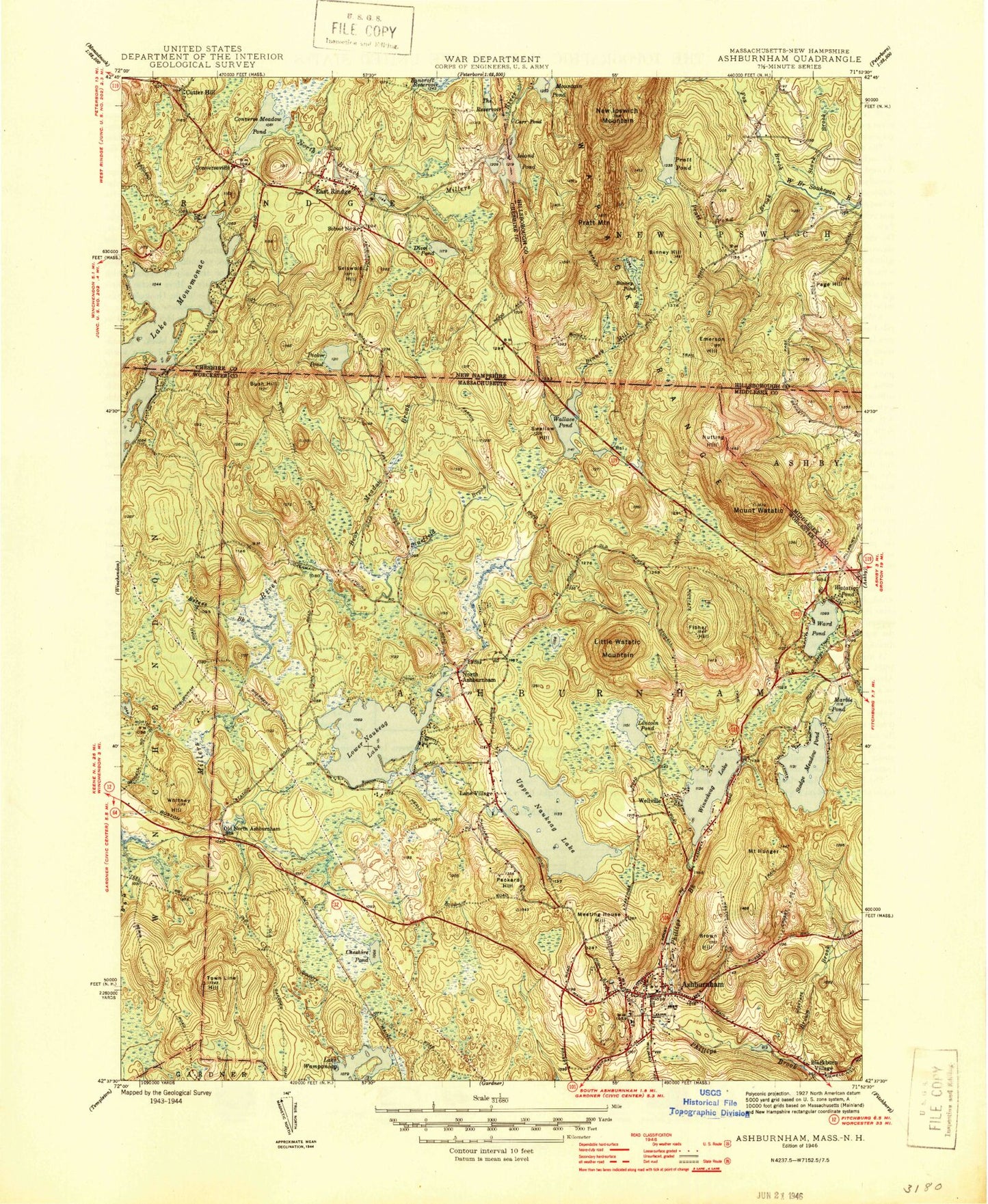
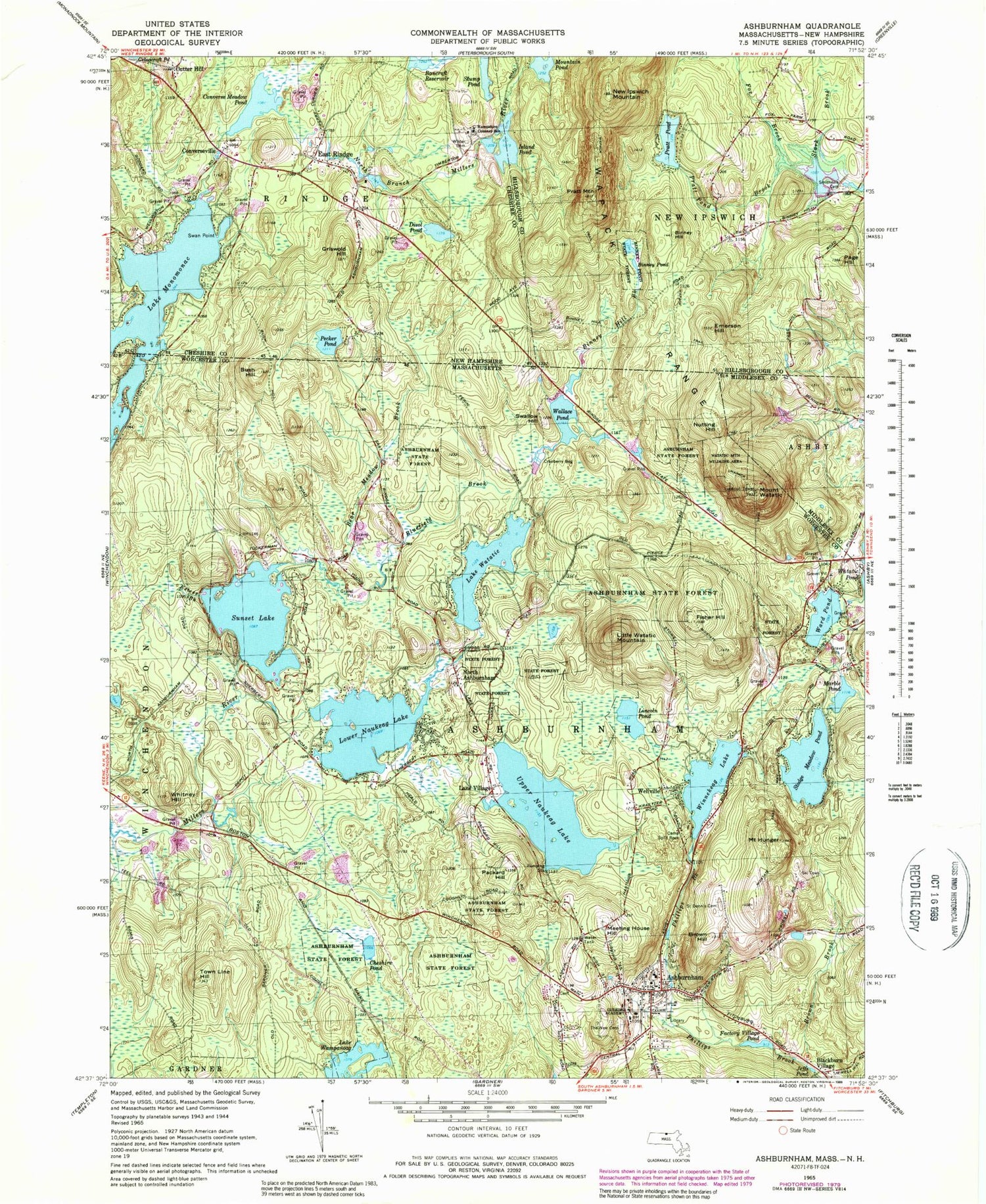
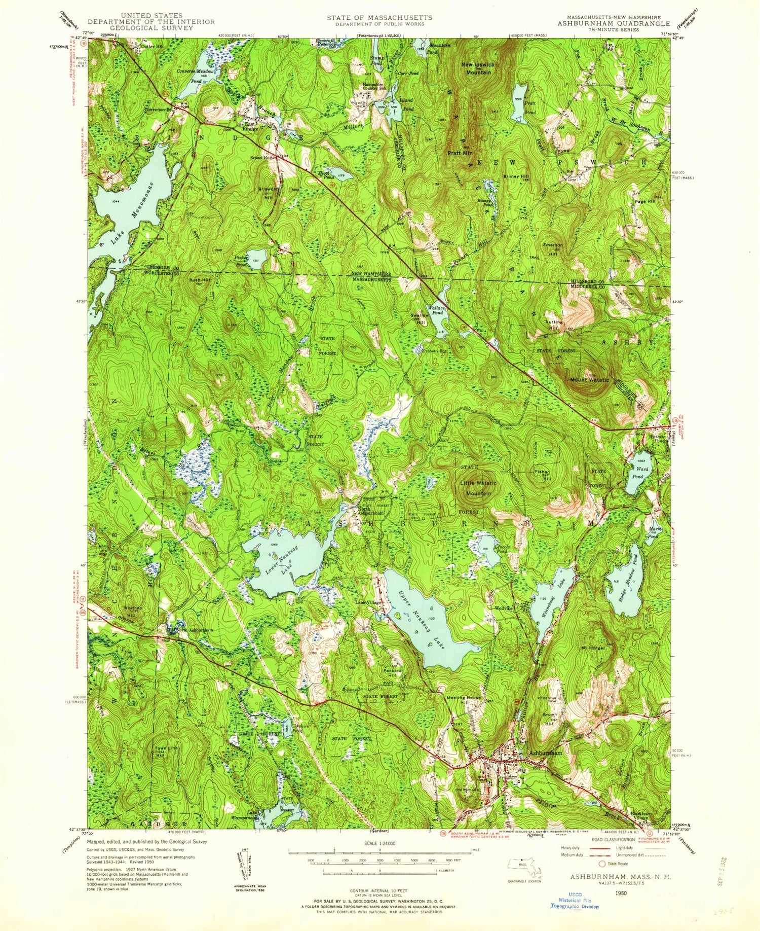
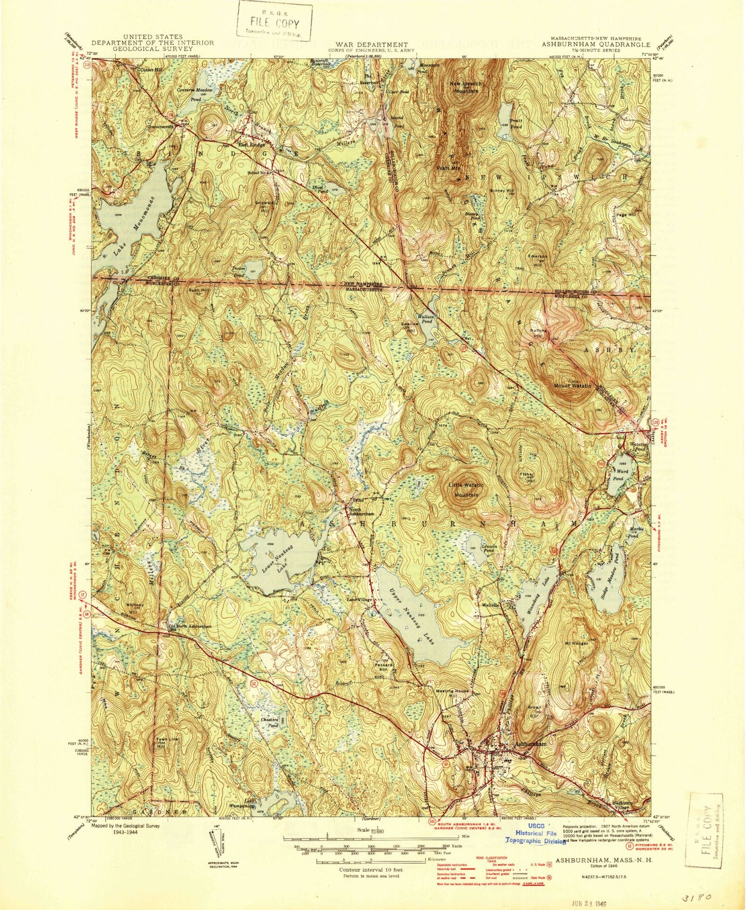
Historical USGS topographic quad map of Ashburnham in the states of Massachusetts, New Hampshire. Typical map scale is 1:24,000, but may vary for certain years, if available. Print size: 24" x 27"
This quadrangle is in the following counties: Cheshire, Hillsborough, Middlesex, Worcester.
The map contains contour lines, roads, rivers, towns, and lakes. Printed on high-quality waterproof paper with UV fade-resistant inks, and shipped rolled.
Contains the following named places: Ashburnham State Forest, Saint Denis Cemetery, Cushing Academy, New Cemetery, Camp Split Rock, Factory Village Pond Dam, Winnekeag Lake Dam, Upper Naukeag Lake Dam, Stodge Meadow Pond Dam, Lower Naukeag Lake Dam, Marble Pond Dam, Sunset Lake Dam, Lake Watatic Dam, Ashburnham, Bear Meadow Brook, Binney Hill Brook, Blackburn Village, Bluefield Brook, Brown Brook, Brown Hill, Bush Hill, Cheshire Pond, Estees Brook, Factory Village Pond, Fisher Hill, Mount Hunger, Jeffs Pond, Lane Village, Lincoln Pond, Little Watatic Mountain, Lower Naukeag Lake, Marble Pond, Meeting House Hill, North Ashburnham, Nutting Hill, Old North Ashburnham Station, Packard Hill, Stodge Meadow Pond, Sunset Lake, Swallow Hill, Town Line Hill, Upper Naukeag Lake, Wallace Pond, Ward Pond, Lake Watatic, Mount Watatic, Wellville, Whitemans Brook, Whitney Hill, Winnekeag Lake, Rocky Hill, Town of Ashburnham, Adams School (historical), Ashburnham Community Church, Ashburnham Post Office, Ashburnham Town Hall, Bickford Field, Peoples Congregational Church, Stevens Memorial Library, Watatic Mountain State Wildlife Area, Mclean Ambulatory Treatment Center at Naukeag, Ashburnham Fire Department Headquarters, Ashburnham Police Department, Fairbanks Cemetery, Lake Monomonac, Bancroft Reservoir, Binney Hill, Binney Pond, Binney Pond State Forest, Converse Meadow Pond, Converseville, Cutter Hill, Divol Pond, East Rindge, Emerson Hill, Fox Brook, Griswold Hill, Hampshire Country School, Island Pond, Mountain Pond, New Ipswich Mountain, Page Hill, Pecker Pond, Pratt Mountain, Pratt Pond, Pratt Pond Brook, Smithville Cemetery, Stark Brook, Stump Pond, Swan Point, Wapack Range, Wilder Cemetery, Mountain Pond Dam, Mill Pond Dam, Mill Pond, Souhegan River Watershed Dam Number 35, Smithville Reservoir, Bancroft Reservoir Dam, Pratt Pond Dam, Stump Pond Dam, Stony Top, Christian Science Camp, Coot Bay, Weatherbee Hill, Heritage Christian School, Ashburnham State Forest, Saint Denis Cemetery, Cushing Academy, New Cemetery, Camp Split Rock, Factory Village Pond Dam, Winnekeag Lake Dam, Upper Naukeag Lake Dam, Stodge Meadow Pond Dam, Lower Naukeag Lake Dam, Marble Pond Dam, Sunset Lake Dam, Lake Watatic Dam, Ashburnham, Bear Meadow Brook, Binney Hill Brook, Blackburn Village, Bluefield Brook, Brown Brook, Brown Hill, Bush Hill, Cheshire Pond, Estees Brook, Factory Village Pond, Fisher Hill, Mount Hunger, Jeffs Pond, Lane Village, Lincoln Pond, Little Watatic Mountain, Lower Naukeag Lake, Marble Pond, Meeting House Hill, North Ashburnham, Nutting Hill, Old North Ashburnham Station, Packard Hill, Stodge Meadow Pond, Sunset Lake, Swallow Hill, Town Line Hill, Upper Naukeag Lake, Wallace Pond, Ward Pond, Lake Watatic, Mount Watatic, Wellville, Whitemans Brook, Whitney Hill, Winnekeag Lake, Rocky Hill, Town of Ashburnham, Adams School (historical), Ashburnham Community Church, Ashburnham Post Office, Ashburnham Town Hall, Bickford Field, Peoples Congregational Church, Stevens Memorial Library, Watatic Mountain State Wildlife Area, Mclean Ambulatory Treatment Center at Naukeag, Ashburnham Fire Department Headquarters, Ashburnham Police Department, Fairbanks Cemetery, Lake Monomonac, Bancroft Reservoir, Binney Hill, Binney Pond, Binney Pond State Forest, Converse Meadow Pond, Converseville, Cutter Hill, Divol Pond, East Rindge, Emerson Hill, Fox Brook, Griswold Hill, Hampshire Country School, Island Pond, Mountain Pond, New Ipswich Mountain, Page Hill, Pecker Pond, Pratt Mountain, Pratt Pond, Pratt Pond Brook, Smithville Cemetery, Stark Brook, Stump Pond, Swan Point, Wapack Range, Wilder Cemetery, Mountain Pond Dam, Mill Pond Dam, Mill Pond, Souhegan River Watershed Dam Number 35, Smithville Reservoir, Bancroft Reservoir Dam, Pratt Pond Dam, Stump Pond Dam, Stony Top, Christian Science Camp, Coot Bay, Weatherbee Hill, Heritage Christian School, Ashburnham State Forest, Saint Denis Cemetery, Cushing Academy, New Cemetery, Camp Split Rock, Factory Village Pond Dam, Winnekeag Lake Dam, Upper Naukeag Lake Dam, Stodge Meadow Pond Dam, Lower Naukeag Lake Dam, Marble Pond Dam, Sunset Lake Dam, Lake Watatic Dam, Ashburnham, Bear Meadow Brook, Binney Hill Brook, Blackburn Village, Bluefield Brook, Brown Brook, Brown Hill, Bush Hill, Cheshire Pond, Estees Brook, Factory Village Pond, Fisher Hill, Mount Hunger