MyTopo
Classic USGS Asheboro North Carolina 7.5'x7.5' Topo Map
Couldn't load pickup availability
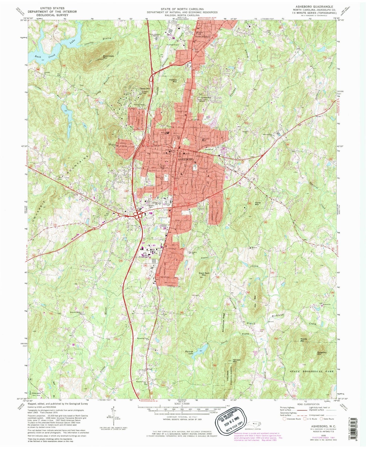
Historical USGS topographic quad map of Asheboro in the state of North Carolina. Typical map scale is 1:24,000, but may vary for certain years, if available. Print size: 24" x 27"
This quadrangle is in the following counties: Randolph.
The map contains contour lines, roads, rivers, towns, and lakes. Printed on high-quality waterproof paper with UV fade-resistant inks, and shipped rolled.
Contains the following named places: Asheboro Junior High School, Asheboro High School, Randolph County, Back Creek Lake, Back Creek Mountain, Balfour School, Browers Church, Browers Pilgrim Church, Central School, Crestview Church, Dogwood Acres Church, Farlows Lake, Giles Chapel, Greenes Branch, Harveys Mountain, Hilltop Church, Loflin School, Long Branch, McCrary School, North Asheboro Junior High School, North Prong Richland Creek, Oaklawn Cemetery, Oakie Mountain, Oakwood Park Church, Randolph Technical Institute, Richland Church, Russells Grove Church, Schoolhouse Ridge, South Prong Richland Creek, Stack Rock Mountain, Tantraugh Branch, Teachey School, Ulah, Vestal Creek, West Chapel, Whispering Pines Church, Hinshaw Airport (historical), Farlow Lake Dam, Shaw-Hudson Lake, Shaw-Hudson Lake Dam, W A McCrary Lake, W A McCrary Lake Dam, John Bunch Lake, John Bunch Lake Dam, Cedarwood Lake, Cedarwood Dam, Lindley Park Elementary School, Asheboro Junior High School, Asheboro High School, Asheboro City Hall, Randolph County Court House, North Carolina Zoological Park, Village Market Place, Hedrick Mountain, Crossroads Center, Hammer Village Shopping Center, Hillside Shopping Center, Northgate Shopping Center, Randolph Mall, Charlotte Church, WCSE-FM (Asheboro), WGWR-AM (Asheboro), Asheboro, Cox Mountain, Daves Mountain, Hedrick Mountain, Horse Mountain, Middle Mountain, North Asheboro, Purgatory Mountain, Cedar Creek, Redding Hills, Westridge, Piney Mountain Estates, Hamlet Lakes, Country Place, North Shore, Winningham Farm, Briarcliff, Laurel Wood Hills, Asheboro Post Office, Township of Asheboro, City of Asheboro, Asheboro Fire Department Station 1, Westside Volunteer Fire and Rescue Department Station 13, Ulah Volunteer Fire Department Station 11, Eastside Volunteer Fire Protection Association Station 1, Ulah Volunteer Fire Protection Station 12, Randolph Hospital, Ash - Rand Rescue Squad, Randolph County Sheriff's Office, Asheboro Police Department, Randolph Correctional Center, Old City Cemetery, Mount Calvary Cemetery, Asheboro Junior High School, Asheboro High School, Randolph County, Back Creek Lake, Back Creek Mountain, Balfour School, Browers Church, Browers Pilgrim Church, Central School, Crestview Church, Dogwood Acres Church, Farlows Lake, Giles Chapel, Greenes Branch, Harveys Mountain, Hilltop Church, Loflin School, Long Branch, McCrary School, North Asheboro Junior High School, North Prong Richland Creek, Oaklawn Cemetery, Oakie Mountain, Oakwood Park Church, Randolph Technical Institute, Richland Church, Russells Grove Church, Schoolhouse Ridge, South Prong Richland Creek, Stack Rock Mountain, Tantraugh Branch, Teachey School, Ulah, Vestal Creek, West Chapel, Whispering Pines Church, Hinshaw Airport (historical), Farlow Lake Dam, Shaw-Hudson Lake, Shaw-Hudson Lake Dam, W A McCrary Lake, W A McCrary Lake Dam, John Bunch Lake, John Bunch Lake Dam, Cedarwood Lake, Cedarwood Dam, Lindley Park Elementary School, Asheboro Junior High School, Asheboro High School, Asheboro City Hall, Randolph County Court House, North Carolina Zoological Park, Village Market Place, Hedrick Mountain, Crossroads Center, Hammer Village Shopping Center, Hillside Shopping Center, Northgate Shopping Center, Randolph Mall, Charlotte Church, WCSE-FM (Asheboro), WGWR-AM (Asheboro), Asheboro, Cox Mountain, Daves Mountain, Hedrick Mountain, Horse Mountain, Middle Mountain, North Asheboro, Purgatory Mountain, Cedar Creek, Redding Hills, Westridge, Piney Mountain Estates, Hamlet Lakes, Country Place, North Shore, Winningham Farm, Briarcliff, Laurel Wood Hills, Asheboro Post Office, Township of Asheboro, City of Asheboro, Asheboro Fire Department Station 1, Westside Volunteer Fire and Rescue Department Station 13, Ulah Volunteer Fire Department Station 11, Eastside Volunteer Fire Protection Association Station 1, Ulah Volunteer Fire Protection Station 12, Randolph Hospital, Ash - Rand Rescue Squad, Randolph County Sheriff's Office, Asheboro Police Department, Randolph Correctional Center, Old City Cemetery, Mount Calvary Cemetery