MyTopo
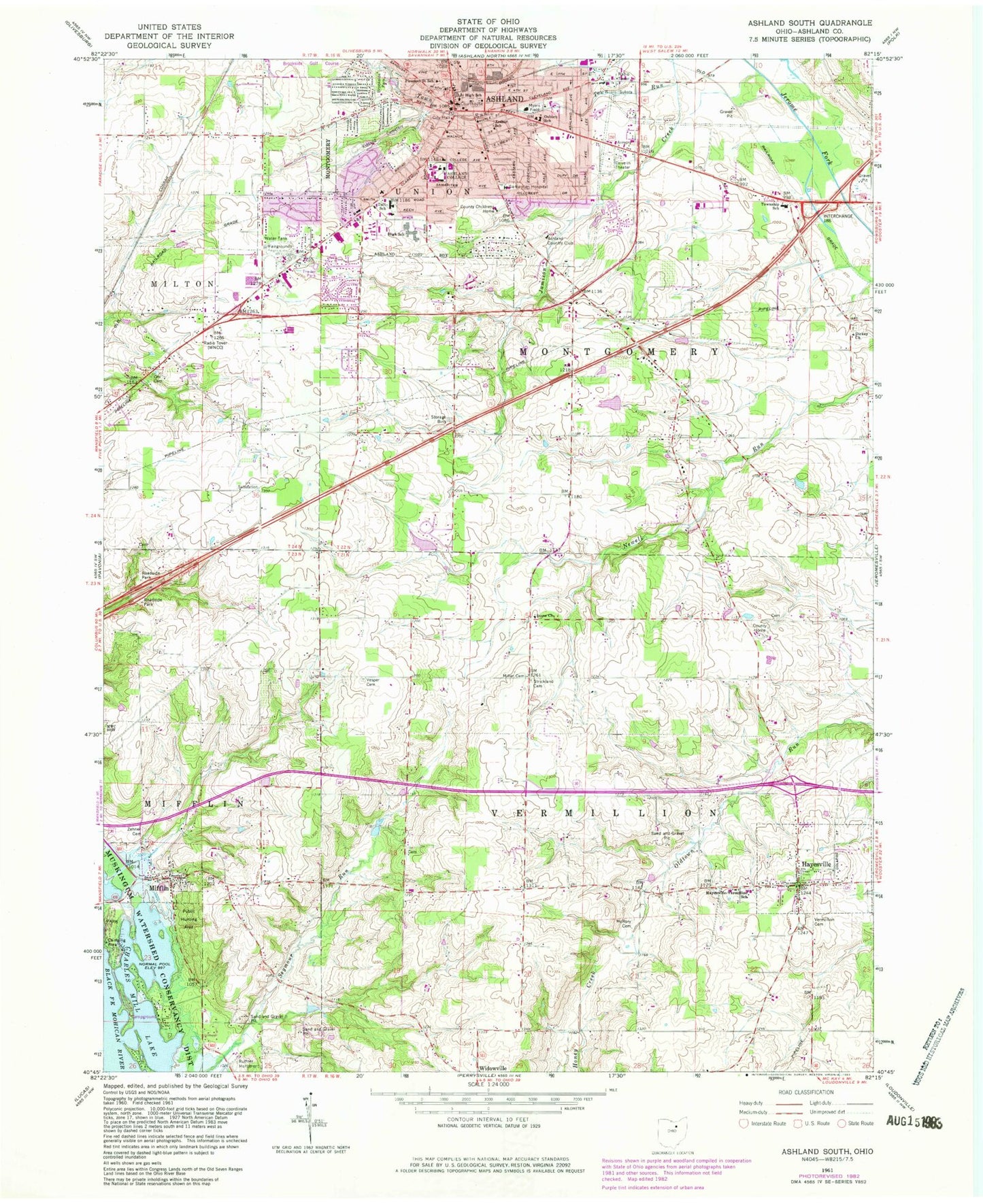
Classic USGS Ashland South Ohio 7.5'x7.5' Topo Map
Couldn't load pickup availability
Historical USGS topographic quad map of Ashland South in the state of Ohio. Map scale may vary for some years, but is generally around 1:24,000. Print size is approximately 24" x 27"
This quadrangle is in the following counties: Ashland.
The map contains contour lines, roads, rivers, towns, and lakes. Printed on high-quality waterproof paper with UV fade-resistant inks, and shipped rolled.
Contains the following named places: Amstutz Hall, Anderson School, Andrews Cemetery, Andrews Hall, Appleseed Orchard, Arthur School, Ashland, Ashland Cemetery, Ashland Christian School, Ashland Country Club, Ashland County, Ashland County Childrens Home, Ashland County Courthouse, Ashland County Fairgrounds, Ashland County Home, Ashland County Jail, Ashland County Joint Vocational School, Ashland County Sheriff's Office, Ashland Fire Department, Ashland High School, Ashland Middle School, Ashland Municipal Building, Ashland Police Department, Ashland Post Office, Ashland Public Library, Ashland Shopping Plaza Shopping Center, Ashland Theological Seminary, Ashland University, Bixler Hall, Bright School, Brookside Golf Course, Brookside Park, Cahn Grove Park, Carpenters Mobile Home Park, Center Street Historic District, Charles Mill Lake Marina, Charles Mill Lake Park, Christ United Methodist Church, City of Ashland, Clark Hall, Clayton Hall, Conrad Field House, County Home Cemetery, Davis Road Park, Dickey Church, Dickey Church Cemetery, Donges Field, First Presbyterian Church, First United Methodist Church, Founders Hall, Gill Center for Business and Economic Education, Grant Street Grade School, Hayesville, Hayesville Elementary School, Hayesville Post Office, Hayesville Vermillion Fire Department, Hopes Mobile Home Park, Hugo Young Theatre, Jacobs Hall, Jacobs Lake, Jacobs Lake Dam, Jamison Creek, John C Myers Convocation Center, John M Ashbrook Center for Public Affairs, Kates Gymnasium, Kem Hall, Kettering Science Center, Kilhefner Hall, Locus Lane Farm, Luray Shopping Center, McAdoo Cemetery, McCrory Cemetery, Memorial Chapel, Mifflin, Mifflin Cemetery, Mifflin Cottage Area, Mifflin Post Office, Mifflin Volunteer Fire Department, Miller Cemetery, Miller Hall, Montgomery Elementary School, Myers Field, Myers Hall, Oakgrove Church, Ohio State Highway Patrol - Ashland Patrol Post, Ohl Cemetery, Osborn Elementary School, Park Street Brethren Church, Patterson Student Center, Peck School, Phyllis Jacobson Kates Center for Human Services, Pleasant Street Elementary School, Redwood Hall, Ruffner Monument, Ruffner Run, Saint Edwards Catholic Church, Saint Edwards School, Samaritan Hospital Heliport, Sarver Field, South Peninsula Cottage Area, Stauffer Farm, Stone Church, Strickland Cemetery, Sultzer Cemetery, Taft Elementary School, Township of Mifflin, Township of Montgomery, Township of Vermillion, Trailerville Mobile Home Park, University Hospitals Samaritan Medical Center, Vermillion Cemetery, Vesper Cemetery, Village of Hayesville, Village of Mifflin, Westview Mobile Home Park, WNCO-AM (Ashland), WNCO-FM (Ashland), WRDL-FM (Ashland), Yeater Farms, Zehner Cemetery, ZIP Codes: 44805, 44838