MyTopo
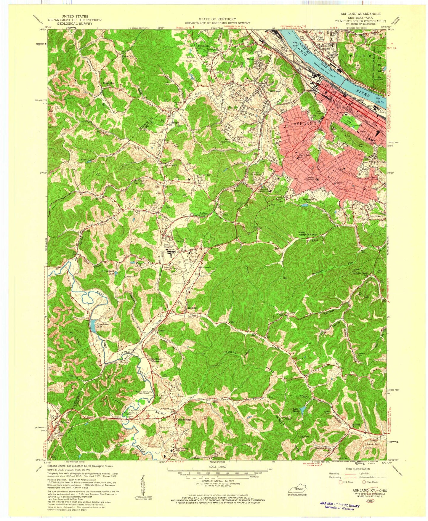
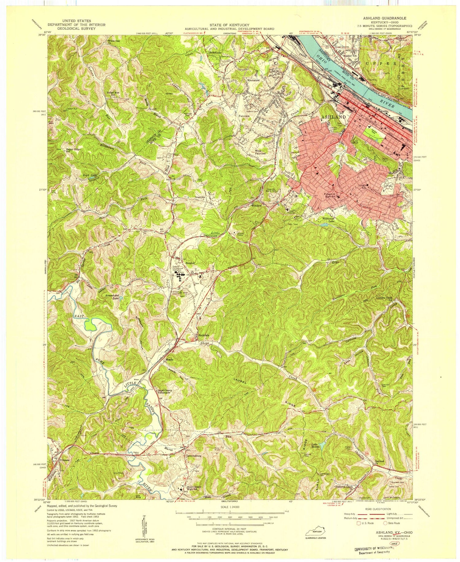
Classic USGS Ashland Kentucky 7.5'x7.5' Topo Map
Couldn't load pickup availability
Historical USGS topographic quad map of Ashland in the states of Kentucky, Ohio. Map scale may vary for some years, but is generally around 1:24,000. Print size is approximately 24" x 27"
This quadrangle is in the following counties: Boyd, Greenup, Lawrence.
The map contains contour lines, roads, rivers, towns, and lakes. Printed on high-quality waterproof paper with UV fade-resistant inks, and shipped rolled.
Contains the following named places: 21st Street Tabernacle, 41101, 41102, Amanda Iron Furnace, Amanda Post Office, Armco Steel, Arrowhead Lake, Ashland, Ashland Division, Ashland Fire Department Central Station, Ashland Fire Department Station 3, Ashland Police Department, Ashland Post Office, Ashland South Division, Ashland State Vocational/Technical School, Bayless School, Bellefonte, Bellefonte Country Club, Bellefonte Furnace Historical Marker, Bellefonte Iron Furnace, Bellefonte Police Department, Bellefonte School, Big Garner Creek, Blazer High School, Bonita Lake, Booker T Washington School, Boyd City High School, Boyd County Tabernacle, Boyd Regional Juvenile Detention Center, Boyd Regional Juvenile Detention Center School, Branham Cemetery, Calvary Cemetery, Camp George M Verity, Cannonsburg, Cannonsburg Census Designated Place, Cannonsburg Fire Protection District, Cannonsburg School, Central Park, Chadwick Creek, Chadwick Creek Church, City of Ashland, City of Bellefonte, Clinton Iron Furnace, Condit School, Crabbe School, Cumpston Cemetery, Daniels Fork, Dickerson Cemetery, Doug Lynn Park, Eads Hollow, Eadson School, East Fork Post Office, Eastham Cemetery, Etna Mission, Fairview, Fairview High School, Federal Correctional Institution Ashland, Gehringer Church, Geigers Crossing, Grandview Lake, Hager School, Hatcher School, Hensly Cemetery, Herd Post Office, Holy Family School, Hood Creek, Hood Creek Church, Hoods Creek Enterprise Baptist Church, Hurricane Fork, Ironville, Ironville Census Designated Place, Ironville School, Johnson Cemetery, Johnson Controls Fire and Rescue, Johnson Fork, Kentucky State Police Post 14, King's Daughters Medical Center, Laurel Ridge, Lawhorn Hollow, Liberty Church, Little Garner, Little Garner Creek, Little Hood Creek, Little Mary Church, Lower Chadwick Creek, Marsh Run, Mary Carol Lake, Mc Knight Cemetery, McNeal Post Office, Meads, Meads Hollow, Meads Railroad Station, Meads School, Memorial United Methodist Church, Millseat, Millseat School, Mock Post Office, Monitor Elementary School, Muddy Branch, Newman Cemetery, Oakland Church, Oakview School, Patton Cemetery, Pineacres School, Poage School, Porter Cemetery, Princess, Princess Iron Furnace, Princess Post Office, Princess Railroad Station, Putnam Junior High School, Rock Lake, Rockdale, Rockdale Church, Rockhouse Fork, Rose Hill Burial Park, Rose Hill Church, Shope Creek, Steele Cemetery, Stephens Hollow, Summit, Summit - Ironville Fire Protection, Summit Census Designated Place, Summit Elementary, Summit Middle School, Sundowner Golf Course, Trinity Church, University of Kentucky Extension Center, Village of Coal Grove, West Fairview, Westwood, Westwood Census Designated Place, Westwood Volunteer Fire Department, White Oak Chapel, WHPI-TV (Ashland), Wildwood Lake, Winslow, Winslow Cemetery, Winslow Post Office, Winslow Railroad Station, WOKT-AM (Cannonsburg), WRVC-FM (Ashland), Zoar Baptist Church