MyTopo
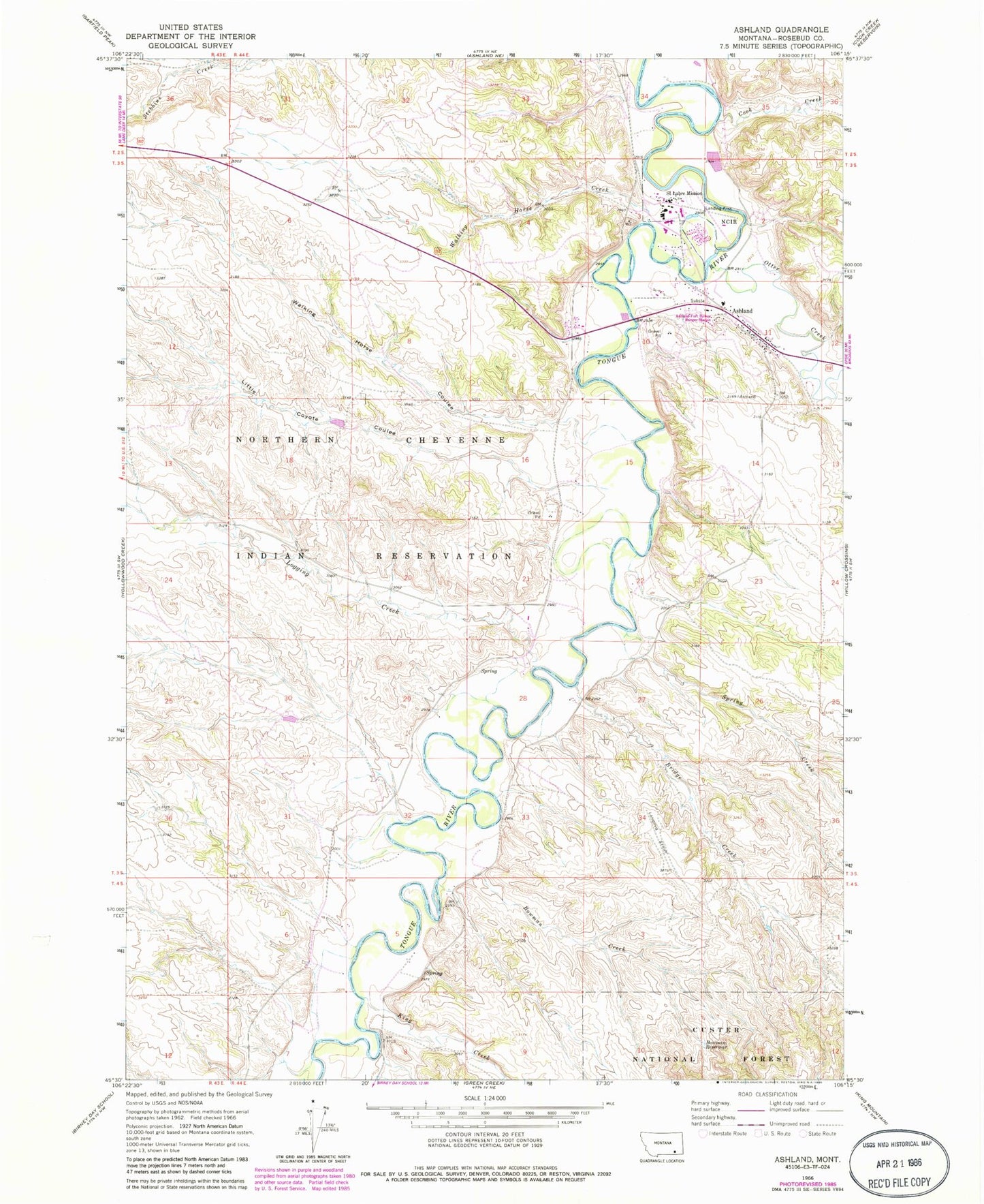
Classic USGS Ashland Montana 7.5'x7.5' Topo Map
Couldn't load pickup availability
Historical USGS topographic quad map of Ashland in the state of Montana. Map scale may vary for some years, but is generally around 1:24,000. Print size is approximately 24" x 27"
This quadrangle is in the following counties: Rosebud.
The map contains contour lines, roads, rivers, towns, and lakes. Printed on high-quality waterproof paper with UV fade-resistant inks, and shipped rolled.
Contains the following named places: 02S44E35DAAB01 Well, 02S44E35DAAB02 Well, 03S43E36BDDB01 Well, 03S44E03A___01 Well, 03S44E03ACA_01 Well, 03S44E03ACB_01 Well, 03S44E03CCC_01 Well, 03S44E03DAB_01 Well, 03S44E03DBB_01 Well, 03S44E03DDB_01 Well, 03S44E09ADA_01 Well, 03S44E09ADD_01 Well, 03S44E10ABD_01 Well, 03S44E10ABD_02 Well, 03S44E10BCC_01 Well, 03S44E10BCC_02 Well, 03S44E10BCD_01 Well, 03S44E10BDBC01 Well, 03S44E10BDC_01 Well, 03S44E10CBB_01 Well, 03S44E11BCAB01 Well, 03S44E11BCAB02 Well, 03S44E11BCAD01 Well, 03S44E11BD__01 Well, 03S44E11DAAA01 Well, 03S44E11DAAC01 Well, 03S44E11DACB01 Well, 03S44E11DBBB01 Well, 03S44E17ABB_01 Well, 03S44E33BDAA01 Well, 04S44E05AAAC01 Well, 04S44E05AAAC02 Well, 04S44E05AAAC03 Well, 04S44E05DBCD01 Well, 04S44E05DBCD02 Well, 04S44E05DBDD01 Spring, 04S44E05DCAC01 Spring, 04S44E08ACDD01 Well, 04S44E12BBDA01 Well, Ashland, Ashland Census Designated Place, Ashland Christian Fellowship, Ashland Community Church, Ashland District, Ashland Fort Howes Ranger Station, Ashland Post Office, Ashland Public School, Ashland Quick Response Unit, Ashland Rural Fire District, Bowman Creek, Bowman Reservoir, Bridge Creek, Bridge Creek Well, Cheyenne Indian Museum, Cook Creek, Cow Creek, Howes, King Creek, Little Coyote Coulee, Logging Creek, Otter Creek, Rosebud County Sheriff's Office Substation, Saint Labre Fire Service, Saint Labre Indian Catholic School, Saint Labre Mission, Spring Creek, St Labre Mission Airport, Walking Horse Coulee, Walking Horse Creek