MyTopo
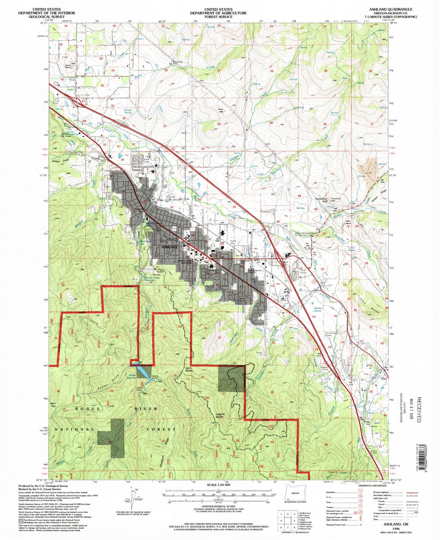
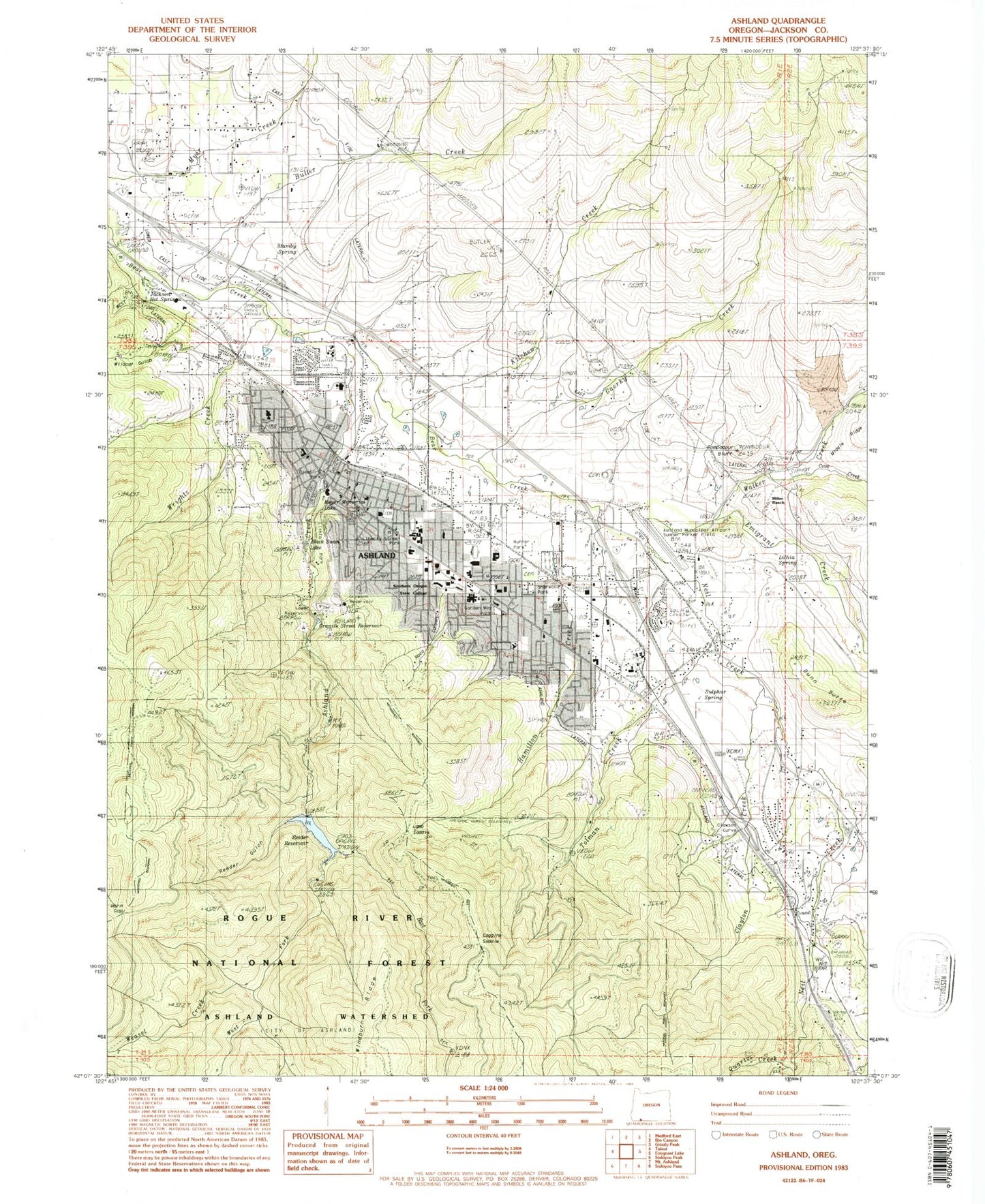
Classic USGS Ashland Oregon 7.5'x7.5' Topo Map
Couldn't load pickup availability
Historical USGS topographic quad map of Ashland in the state of Oregon. Typical map scale is 1:24,000, but may vary for certain years, if available. Print size: 24" x 27"
This quadrangle is in the following counties: Jackson.
The map contains contour lines, roads, rivers, towns, and lakes. Printed on high-quality waterproof paper with UV fade-resistant inks, and shipped rolled.
Contains the following named places: Winburn Mountain, Wildcat Canyon, Jackson Hot Springs, Miller Ranch, Granite Street Reservoir, Crowson Reservoir, Black Swan Lake, Meyer Memorial Lake, La Marre Reservoir, Dunn Butte, Clawson (historical), Corp Reservoirs, Merriman Reservoir, Weasel Creek, Billings Reservoir, Belleview, Ropers Bunion, Roca Canyon, Clay Creek, Clawson Curve, Oregon Tourism Safety Rest Area (historical), Lamb Saddle, Quartz Creek, Ashland, Ashland Creek, Butler Creek, Clayton Creek, Cove Creek, East Fork Ashland Creek, Emigrant Creek, Gaerky Creek, Horn Gap, Lithia Park, Lithia Spring, Lower East Lateral, Lower Reservoir (historical), Mistletoe (historical), Neil Creek, Pompadour Bluff, Reeder Gulch, Reeder Reservoir, Skyline Mine, Southern Oregon State University, Tolman Creek, Walker Creek, West Fork Ashland Creek, Winburn Camp, KDOV-AM, Reeder Gulch Dam, Ashland Municipal Airport-Sumner Parker Field, Wildcat Gulch, Coggins Saddle, Lamb Mine, Jemmison Gulch, Wrights Creek, Mountain View Cemetery, West Fork Wrights Creek, Mountain View Cemetery, Ashland Cemetery, Sulphur Springs, Sulphur Springs, Danns Spring, Hamby Spring, Scenic Hills Cemetery, Hargadine Cemetery, Meyers Cemetery, Ashland Watershed, Winburn Ridge, Ashland Research Natural Area, KCMX-FM, KCMX-AM, Ashland Ranger Station, Ashland Forest Service Facility (historical), Oak Knoll Golf Course, Ashland Post Office, Ashland Ranger Station (historical), Ashland Division, Hamilton Creek, Ashland Community Hospital, Ashland Dog Park, Ashland Fire and Rescue Station 1, Ashland Fire and Rescue Station 2, Ashland Police Department, Bluebird Park, Calle Guanajuato, Clay Street Park, Garden Way Park, Garfield Park, Glenwood Park, Hald/Strawberry Park, Liberty Street Park, North Mountain Park, Oredson Todd Woods, Railroad Park, Scenic Park, Sherwood Park, Siskiyou Mountain Park, Community Skate Park, Southern Oregon University Nat, Triangle Park, Ashland Creek Park, YMCA Park, Kitchen Creek, City of Ashland, Ashland High School, Ashland Middle School, Bellview Elementary School, Helman Elementary School, Walker Elementary School, John Muir Elementary School, United States Forest Service Ashland Ranger District, Cemetery Creek, Paradise Creek, Beach Creek, Roca Creek, Ashland Wastewater Treatment Plant, Ashland Water Treatment Plant, Angnus Bowmer Theatre, Ashland City Hall, Ashland Historic Railroad Museum, Ashland Municipal Court, Ashland Public Library, Ashland Public Works Department, Ashland School District Mountain Avenue Theatre, Carpenter Hall, Ashland Rotary Centennial Outdoor Ice Rink, Department of Motor Vehicles Ashland, Elizabethan Stage / Allen Pavilion, Lithia Park Butler Bandshell, New Theatre, Oregon Cabaret Theatre, Rogue Valley Metaphysical Library, Science Works Hands - On Museum, Southern Oregon University, Southern Oregon University McNeal Pavilion, Southern Oregon University Music Recital Hall, Southern Oregon University Raider Stadium, Southern Oregon University Schneider Museum of Art, Southern Oregon University Theatre Arts Building, Timberland Shop Heliport, Rogue River Siskiyou National Forest Law Enforcement Ashland, Southern Oregon University Campus Public Safety Office Police Department, Clark R Bavin National Fish and Wildlife Forensics Laboratory