
MyTopo
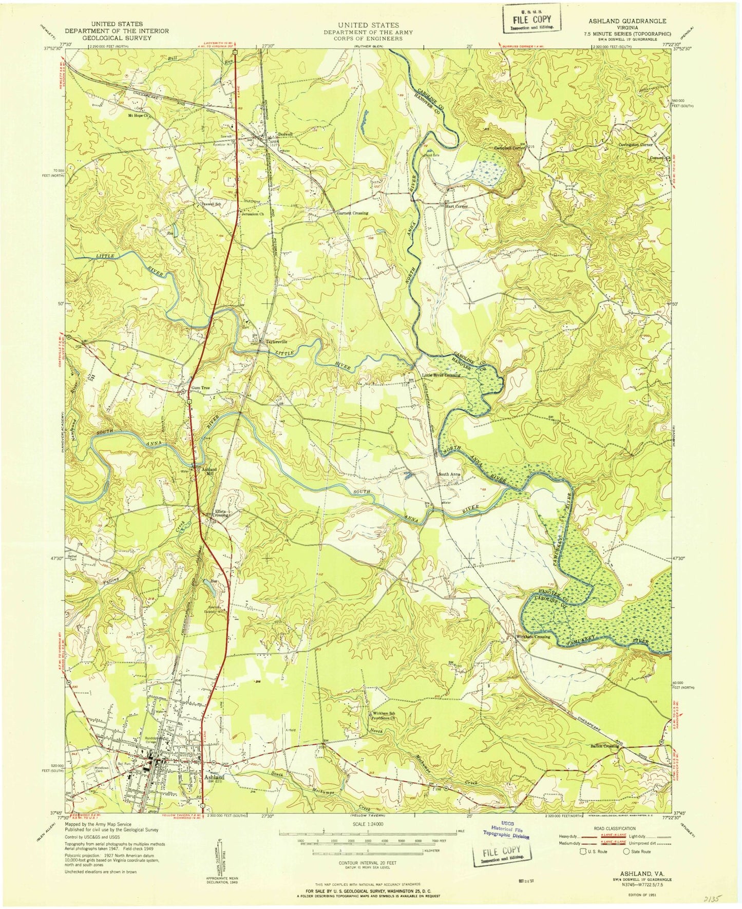
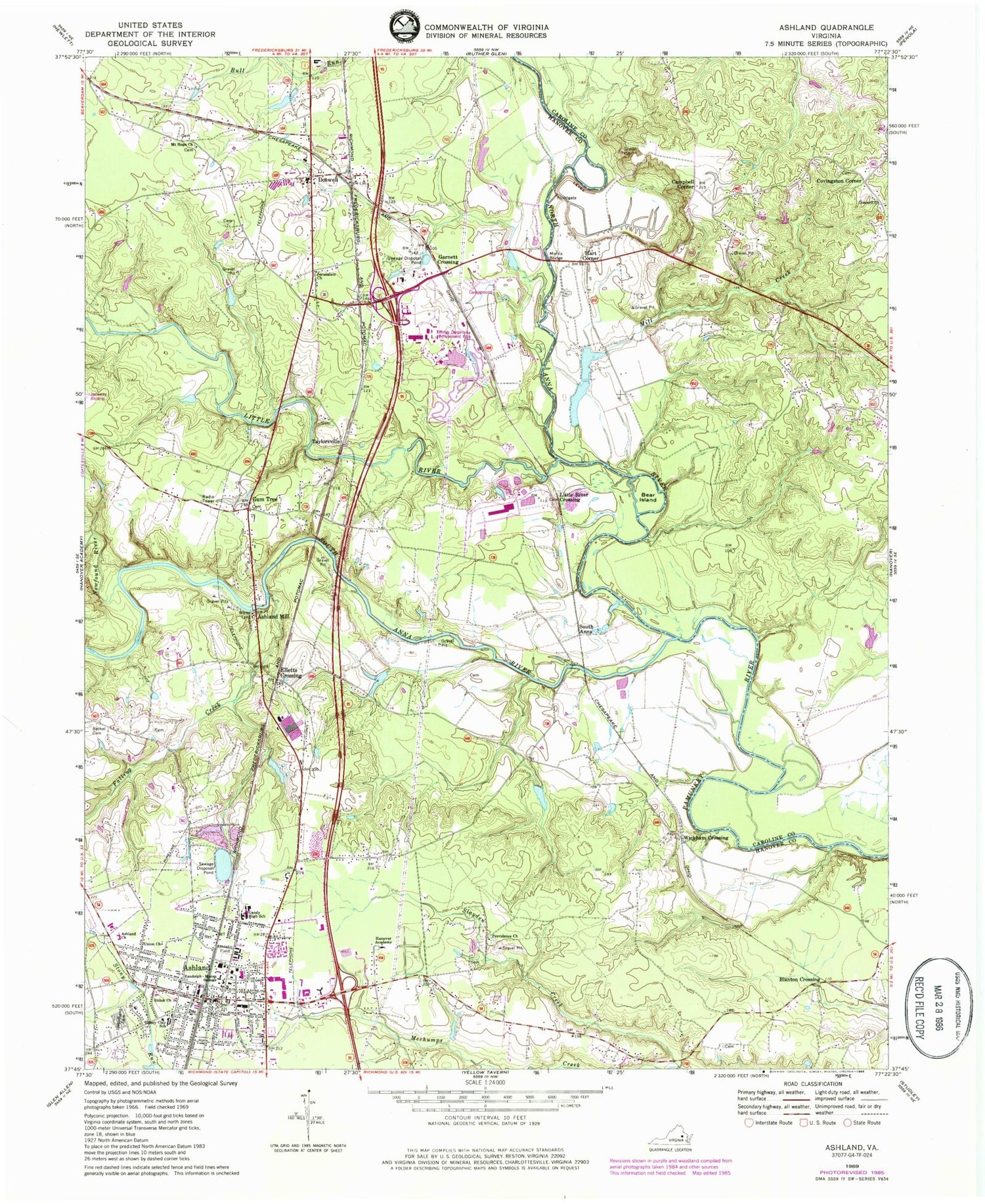
Classic USGS Ashland Virginia 7.5'x7.5' Topo Map
Couldn't load pickup availability
Historical USGS topographic quad map of Ashland in the state of Virginia. Typical map scale is 1:24,000, but may vary for certain years, if available. Print size: 24" x 27"
This quadrangle is in the following counties: Caroline, Hanover.
The map contains contour lines, roads, rivers, towns, and lakes. Printed on high-quality waterproof paper with UV fade-resistant inks, and shipped rolled.
Contains the following named places: Ashland Church, Bear Island, Little Bethel Methodist Church Cemetery, Falling Creek, John M Gandy Elementary School, Hanover Academy, Henry Clay Elementary School, Jerusalem Church, Little River, Mill Creek, Morris Bridge, Mount Hope Church, Newfound River, North Anna River, Providence Church, Randolph - Macon College, Shiloh Church, Slayden Creek, South Anna River, Union Church, Woodland Cemetery, Blanton Crossing, Campbell Corner, Covingston Corner, Elletts Crossing, Wickham Crossing, Hanover County, Jones Dam Number Two, Jones Pond, Sewage Disposal Pond Dam, Sewage Disposal Pond, Ashland, Ashland Mill, Doswell, Garnett Crossing, Gum Tree, Hart Corner, Little River Crossing, South Anna, Taylorsville, Meadow Farm Airport (historical), Mayers Airport, Concord Baptist Cemetery, Carters Ford, Doswell School (historical), Doswell School (historical), Kings Dominion Amusement Park, Providence Baptist Church Cemetery, Taylorsville Baptist Church, Wickham School (historical), Ashland Baptist Church, Ashland Convalescent Center, Ashland Grammar School, Ashland Junction Shopping Center, Ashland Post Office, Ashland-Hanover Shopping Center, Ashland Historic District, HealthSouth Medical Center, Ashland Municipal Building, Ashland Presbyterian Church, Blackwell Auditorium, DeJarnette Park, Duncan Memorial Methodist Episcopal Church South (historical), Henry Clay Shopping Center, McGraw-Page Library, North Ashland Plaza Shopping Center, Saint Annes Roman Catholic Church, Sedgefield Mobile Home Park, South Taylor Street Park, Theresa A Thomas Medical Center, War Memorial Gymnasium, Hanover County Fire - EMS Company 1 - Ashland Volunteer Fire Station, Hanover County Fire - EMS Company 4 - Doswell Volunteer Fire Station, Weir Creek Emergency Services, Alpha Gamma Delta House, Bennett Residence Hall, Birdsong Townhouse, Blackwell Auditorium and Cobb Theatre, Blackwell House, Blincoe Field, Bowen Tennis Courts, Clements Townhouse, Cochrane Townhouse, Conrad Residence Hall, Copley Science Center, Crenshaw and Alumni Gymnasiums, Delta Zeta House, Estes Dining Hall, Flippo Townhouse, Frank E Brown Campus Center, Garland Residence Hall, Haley Hall, Higgins Academic Center, Hugh Stephens Baseball Complex, Irby Residence Hall, Jordan Wheat Lambert Historic Campus, Kappa Alpha House, Kappa Alpha Theta House, Kappa Sigma House, Keeble Observatory, Lambda Chi Alpha House, LEAPS Center, Mabry House, Mary Branch Residence Hall, McGraw - Page Library, Moreland Residence Hall, Neville House, Olin Residence Hall, Pace - Armistead Hall, Pannill House, Peele Hall Administration Building, Phi Delta Theta, Phi Mu House, President's House - Randolph-Macon College, Ragland - Henry House, Rhodeen House, Saint Ann's Building, Sigma Alpha Epsilon House, Starr Residence Hall, Taylor Street House, The Brock Center, Theta Chi House, Thomas Branch Hall, Washington and Franklin Hall, Hanover County Fire - EMS Company 16 - Ashland Volunteer Rescue Squad, Ashland Police Department, Town of Ashland, Pamunkey Regional Library Richard S Gillis Jr Ashland Branch Library, Doswell Post Office, Meadow Event Park