MyTopo
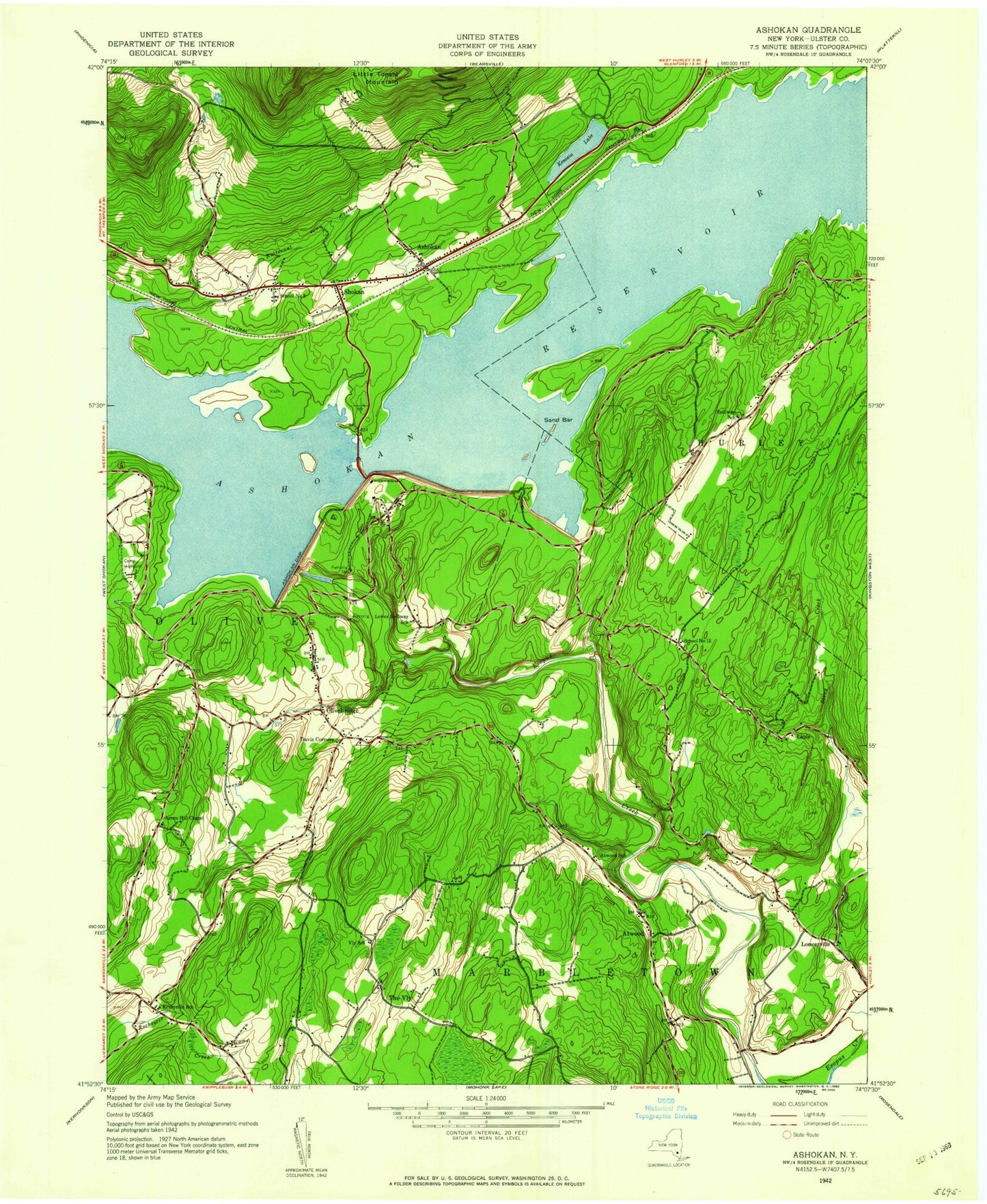
Classic USGS Ashokan New York 7.5'x7.5' Topo Map
Couldn't load pickup availability
Historical USGS topographic quad map of Ashokan in the state of New York. Typical map scale is 1:24,000, but may vary for certain years, if available. Print size: 24" x 27"
This quadrangle is in the following counties: Ulster.
The map contains contour lines, roads, rivers, towns, and lakes. Printed on high-quality waterproof paper with UV fade-resistant inks, and shipped rolled.
Contains the following named places: Acorn Hill Church, Ashokan, Ashokan Dam, Ashokan Reservoir, Ashokan Reservoir Aerator, Atwood, Butternut Creek, Davis Corners, Kenozia Lake, Krumville, Lapla, Little Tonshi Mountain, Lomontville, Olivebridge, Shokan, State University College at New Paltz Camp, The Vly Chapel, Tongore Cemetery, Pacama, The Vly, Stone Ridge Heliport, Camp High Point, Ashokam School (historical), Atwood School (historical), District 3 School (historical), District 12 School (historical), Krumville School (historical), Lomontville School (historical), Lower Spillway School (historical), Olive Bridge School (historical), Spillway School (historical), Vly School (historical), Shokan Census Designated Place, Ashokan Bridge, Hasbrouck Farms, Lomontville Assembly of God, Olivebridge Post Office, Shokan Post Office, Ashokan Ridge, Ashokan Reservoir West Basin, Ashokan Reservoir East Basin, Olive Volunteer Fire Department 1 Olivebridge Company 1, Vly Atwood Volunteer Fire Company, Olive Volunteer Fire Department 1 Shokan Company 2, Krumville Cemetery, Acorn Hill Church, Ashokan, Ashokan Dam, Ashokan Reservoir, Ashokan Reservoir Aerator, Atwood, Butternut Creek, Davis Corners, Kenozia Lake, Krumville, Lapla, Little Tonshi Mountain, Lomontville, Olivebridge, Shokan, State University College at New Paltz Camp, The Vly Chapel, Tongore Cemetery, Pacama, The Vly, Stone Ridge Heliport, Camp High Point, Ashokam School (historical), Atwood School (historical), District 3 School (historical), District 12 School (historical), Krumville School (historical), Lomontville School (historical), Lower Spillway School (historical), Olive Bridge School (historical), Spillway School (historical), Vly School (historical), Shokan Census Designated Place, Ashokan Bridge, Hasbrouck Farms, Lomontville Assembly of God, Olivebridge Post Office, Shokan Post Office, Ashokan Ridge, Ashokan Reservoir West Basin, Ashokan Reservoir East Basin, Olive Volunteer Fire Department 1 Olivebridge Company 1, Vly Atwood Volunteer Fire Company, Olive Volunteer Fire Department 1 Shokan Company 2, Krumville Cemetery