MyTopo
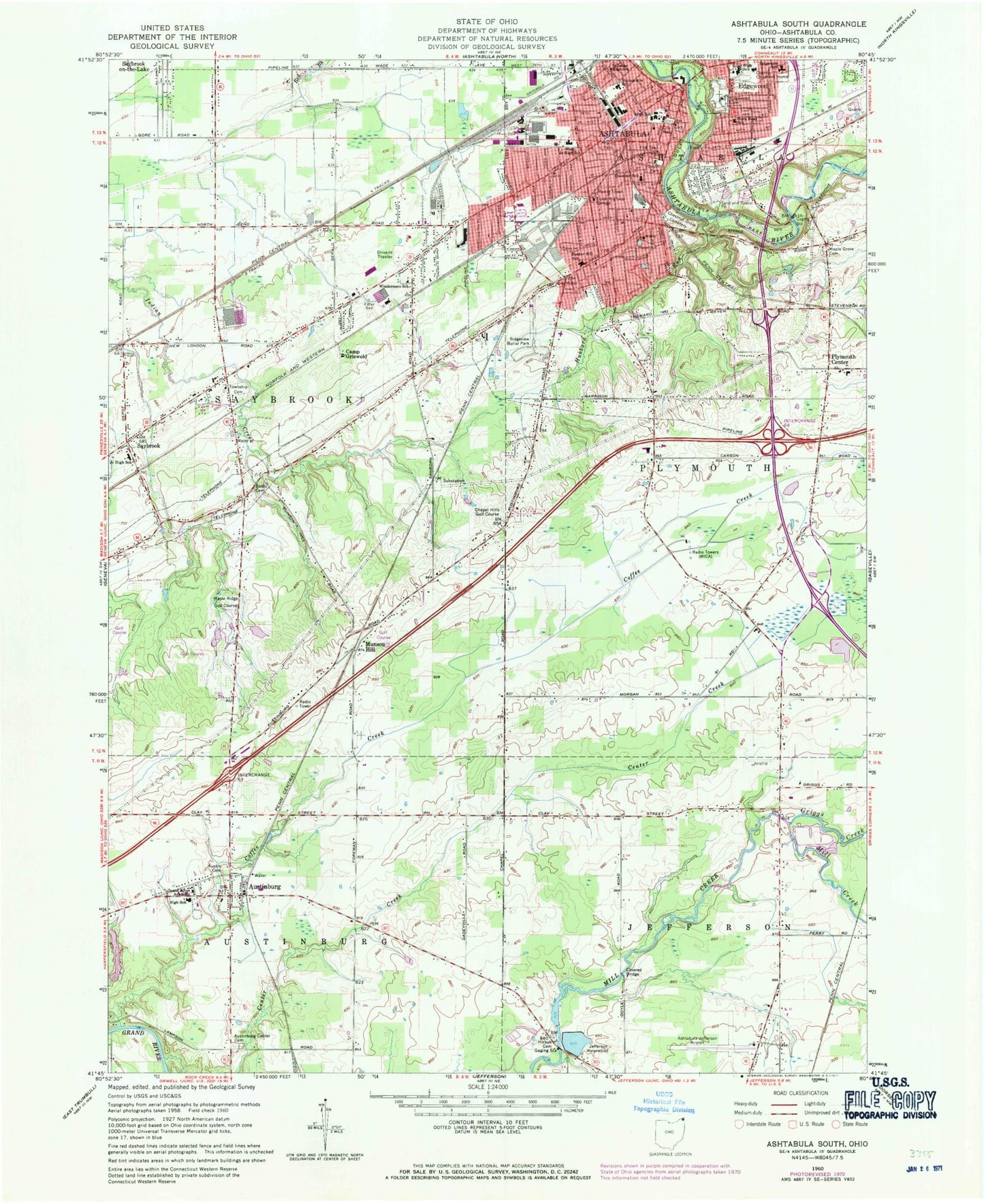
Classic USGS Ashtabula South Ohio 7.5'x7.5' Topo Map
Couldn't load pickup availability
Historical USGS topographic quad map of Ashtabula South in the state of Ohio. Map scale may vary for some years, but is generally around 1:24,000. Print size is approximately 24" x 27"
This quadrangle is in the following counties: Ashtabula.
The map contains contour lines, roads, rivers, towns, and lakes. Printed on high-quality waterproof paper with UV fade-resistant inks, and shipped rolled.
Contains the following named places: A C Mobile Home Park, Apostolic Faith Church, Ashtabula, Ashtabula County Childrens Home, Ashtabula Fire Department, Ashtabula Free Public Library, Ashtabula Municipal Building, Ashtabula Police Department, Ashtabula Post Office, Austin Cemetery, Austinburg, Austinburg Census Designated Place, Austinburg Center Cemetery, Austinburg Elementary School, Austinburg First United Church of Christ, Austinburg Post Office, Austinburg Township Park, Austinburg Volunteer Fire Department, Bates Cemetery, Bible Baptist Church, Brail Lake, Brail Lake Dam, Camp Griswold, Center Creek, Chapel, Chapel Hills Golf Course, Chestnut Elementary School, Chestnut Grove Cemetery, Church of Christ, Church of God in Christ, Church of the Nazarene, Coffee Creek, County Childrens Home, Crestlawn Village, Cross Roads Plaza Shopping Center, Csonka Brothers Pond, Csonka Brothers Pond Dam, Doyle Road Bridge, East Side Presbyterian Church, Edgewood, Edgewood Cemetery, Edgewood Public School, First Baptist Church, First Church of Christ Scientist, First Congregational United Church of Christ, First Grace Gospel Church, First Presbyterian Church, First Spiritual Church, First Swedish Evangelical Mission Covenant Church, First United Methodist Church, Grand River Academy, Griggs Creek, Harbor Baptist Church, Harris Memorial Presbyterian Church, Hickok Cemetery, Hubbard Run, Jefferson Airport, Jefferson Mobile Estates, Jefferson Waterworks, Kingdom Hall of Jehovahs Witnesses, Lakeside High School, Lampson Reservoir, Lampson Reservoir Dam, M And M Orchard, Maple Grove Cemetery, Maple Ridge Golf Course, March Farms, McKinsey Elementary School, Meadowood, Messiah Lutheran Church, Millers Buffalo Ranch, Munson Hill, Munson Hill Post Office, North Park, Ohio State Highway Patrol - Ashtabula Patrol Post, Old Ashtabula Cemetery, Parkwood Village, Peoples Baptist Church, Plymouth Center, Plymouth Elementary School, Plymouth Township Fire Department, Plymouth United Methodist Church, Plymouth Volunteer Fire and Rescue Company Station 2, Point Park, Prospect Presbyterian Church, Ridgeview Burial Park, Ridgeview Elementary School, Saint Johns High School, Saint Johns School, Saint Joseph Roman Catholic Mission, Saint Peters Episcopal Church, Saybrook, Saybrook Elementary School, Saybrook Medical Center, Saybrook Plaza Shopping Center, Saybrook Station, Saybrook Township Fire Department Station 1 Headquarters, Saybrook Township Fire Department Station Number 3, Saybrook United Methodist Church, Smith Home for Aged Women, South Park, State Road Elementary School, Thurgood Marshall Elementary School, Tifereth Israel Congregation, Township Cemetery, Township of Austinburg, Township of Jefferson, Township of Plymouth, Township of Saybrook, Trinity United Methodist Church, Union Missionary Baptist Church, Utterback Farm, Wallace H Braden Junior High School, WAST-AM (Ashtabula), West Avenue Church of God in Christ, West Avenue Public School, West End Station Ashtabula Post Office, West Junior High School, WFUN-AM (Ashtabula), Wilso Dairy, Woodman Mobile Home Park, WREO-FM (Ashtabula), WZOO-FM (Edgewood), ZIP Codes: 44004, 44010