MyTopo
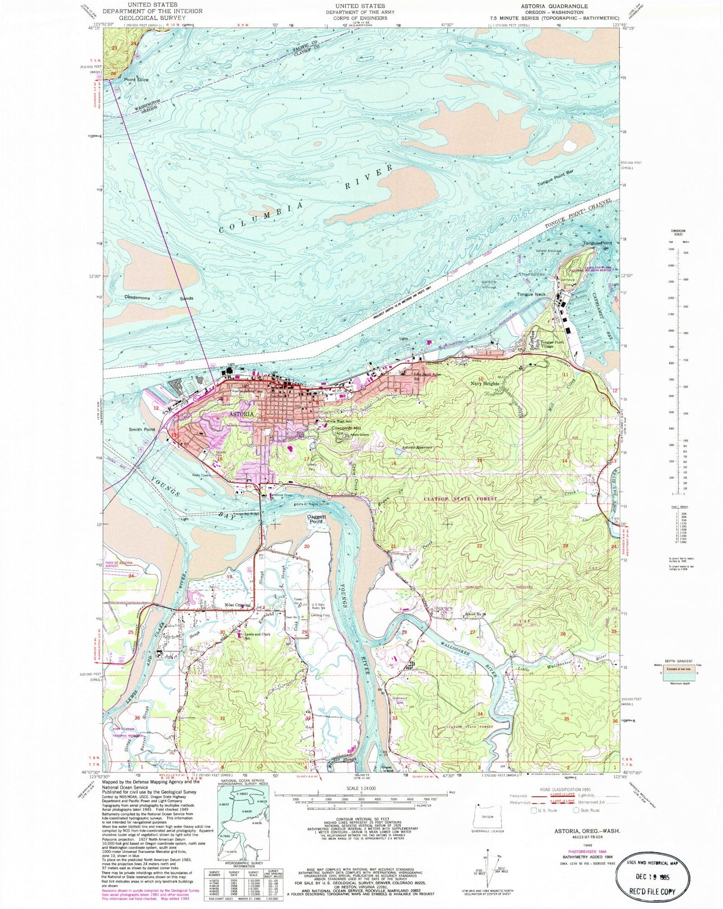
Classic USGS Astoria Oregon 7.5'x7.5' Topo Map
Couldn't load pickup availability
Historical USGS topographic quad map of Astoria in the states of Oregon, Washington. Typical map scale is 1:24,000, but may vary for certain years, if available. Print size: 24" x 27"
This quadrangle is in the following counties: Clatsop, Pacific.
The map contains contour lines, roads, rivers, towns, and lakes. Printed on high-quality waterproof paper with UV fade-resistant inks, and shipped rolled.
Contains the following named places: Astoria Column, Astoria, Astoria Air Marine Service, Astoria Megler Ferry (historical), Barrett Creek, Barrett Slough, Brown Creek, Cook Slough, Coxcomb Hill, Craig Creek, Crosel Creek, Daggett Point, Fry Island, Green Slough, Greenwood Cemetery, Jack Creek, Jeffers Slough, Astor Elementary School, Knowland Slough, Lewis and Clark River, Lewis and Clark Elementary School, Little Wallooskee River, Miles Crossing, Mill Creek, School Number 26 (historical), Shively Park, Smith Point, Taylor Sands, Tongue Neck, Tongue Point, Tongue Point Bar, Tongue Point Channel, Wallooskee River, Youngs Bay, Youngs Bay Bridge US-101 Alternate, Youngs Bay Light, Riverview Cemetery, Pioneer Cemetery, Trotter, Jeffers Garden, Stewart Creek, Mott Basin, Astoria Bridge, KBKN-FM, KVAS-AM, Navy Heights, Tongue Point Village, Clatsop Community College, Astoria Reservoir, Tongue Point Naval Base (historical), KAST - AM, Astoria Range, Astoria Middle School, Astoria Senior High School, Gray Elementary School, Clatsop County Home, Weather Bureau Tower, Tongue Point Lighthouse, United States Navy Radio Tower Number One, United States Navy Radio Tower Number Three, Upper Sands, Quarantine Anchorage, United States Navy Radio Station, Bonneville Power Station, Astoria Post Office, Lower Astoria Post Office (historical), Navy 10371 Post Office (historical), Navy 13027 Post Office (historical), Upper Astoria Post Office (historical), Tongue Point Naval Station Post Office (historical), Van Dusen (historical), Mill Creek Naval Spur (historical), Tongue Point, Alderbrook (historical), Halco (historical), Port Dock (historical), Oregon State Forestry District Headquarters, John Warren Field, Boonesborough, Tapiola Park, Astoria Bridge Toll Plaza, Columbia Memorial Hospital, Astoria Reservoir Number Two, Lewis and Clark River Bridge, Youngs Bay Bridge, Uniontown, Astoria Division, Tongue Point Naval Air Station (historical), Saint Mary Star of the Sea School, City of Astoria, First Church of the Nazarene, Grace Episcopal Church, Astoria Fire Department Station 1, Olney - Walluski Volunteer Fire and Rescue District, Lewis and Clark Rural Fire Department, Oregon Department of Forestry Astoria District, Astoria Fire Department Station 2, Jeffers Gardens Census Designated Place, Medix Ambulance Service, City of Astoria Wastewater Treatment Facility, John Day Water District, Astoria Municipal Court, Astoria Public Library, Clatsop Community College Performing Arts Center, Columbia River Maritime Museum, Astoria Children Museum, Uppertown Firefighters Museum, Captain George Flavel House, Heritage Museum, Astoria Public Works Operations, Clatsop County Public Works, Department of Motor Vehicles Astoria, United States Coast Guard Aids to Navigation Team Astoria, Clatsop County Courthouse, Astoria City Hall, Liberty Theatre, Astor Street Opry Company Live Theatre, Clatsop County Fairgrounds, Red Cross Astoria Satellite Office, Young's Bay Marine Park - Yacht Club Boat Launch, Columbia Memorial Hospital Heliport, East Mooring Basin Boat Ramp, Columbia River Maritime Museum Park and Ride, East Mooring Basin, West Mooring Basin, Port of Astoria, 17th Street Transient Dock, Astoria Transit Center, John Day County Park Boat Ramp, Clatsop County Public Health Department, Clatsop County Sheriff's Office, Astoria Police Department, Oregon State Police Department Astoria Area Command Office, United States Customs and Border Protection Port of Entry Astoria, River Point Census Designated Place, Point Ellice