MyTopo
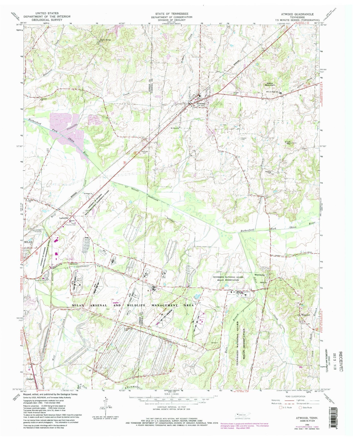
Classic USGS Atwood Tennessee 7.5'x7.5' Topo Map
Couldn't load pickup availability
Historical USGS topographic quad map of Atwood in the state of Tennessee. Typical map scale is 1:24,000, but may vary for certain years, if available. Print size: 24" x 27"
This quadrangle is in the following counties: Carroll, Gibson.
The map contains contour lines, roads, rivers, towns, and lakes. Printed on high-quality waterproof paper with UV fade-resistant inks, and shipped rolled.
Contains the following named places: Steep Bank Branch, University of Tennessee Agricultural Experimental Farm, Webb Mountain, West Fork Wolf Creek, Wolf Creek, Atwood, Clark Mountain, Clear Creek, Cressville Creek, East Fork Wolf Creek, Fairview Church, Friendship Cemetery, Halls Branch, Hopewell, Howse Baptist Church, Johns Creek, Keaton Cemetery, Ledbetter, MTA Junior High School, Milan Country Club, Newhope Cemetery, Pisgah Cemetery, Poplar Springs Church, Sandy Branch, Creswell Lake Number Twenty-eight, Creswell Lake Number Twenty-one, Creswell Lake Number Twenty-eight Dam, Creswell Lake Number Twenty-five, Creswell Lake Number Twenty-three, Creswell Lake Number Twenty-one Dam, Creswell Lake Number Twenty-nine, Creswell Lake Number Twenty-four Dam, Creswell Lake Number Twenty-four, Creswell Lake Number Twenty-five Dam, Creswell Lake Number Twenty-nine Dam, Creswell Lake Number Thirty-eight, Creswell Lake Number Thirty-eight Dam, Creswell Lake Number Thirty-five, Creswell Lake Number Thirty-five Dam, Creswell Lake Number Thirty-four, Creswell Lake Number Thirty-four Dam, Creswell Lake Number Thirty-three, Creswell Lake Number Thirty-three Dam, Creswell Lake Number Thirty-two, Creswell Lake Number Thirty-two Dam, Creswell Lake Number Thirty-one, Creswell Lake Number Thirty-one Dam, Creswell Lake Number Twenty-three Dam, Luckey Lake, Luckey Lake Dam, Shiloh Church, Whitthorne, Howse, New Hope (historical), Atwood First Baptist Church, Atwood Junior High School, Hopewell Baptist Church, Houser School (historical), Brick Hill School (historical), Bryant Chapel (historical), Bryant Chapel School (historical), Cunningham School (historical), Hammond School (historical), Milan High School, Moore School (historical), Poplar Springs Cemetery, Salem School (historical), District 20 (historical), District 21 (historical), Shiloh Cemetery, Milan City Park, Milan Vocational-Technical School, Rotary Field, Temple Church, Mount Olive Church, New Hope Baptist Church, Salem Church, Pisgah Presbyterian Church (historical), Atwood Post Office, Town of Atwood, Commissioner District 12, Commissioner District 15, Milan Army Ammunition Plant, Atwood Volunteer Fire Department, Milan Army Ammunition Plant Fire and Emergency Medical Service