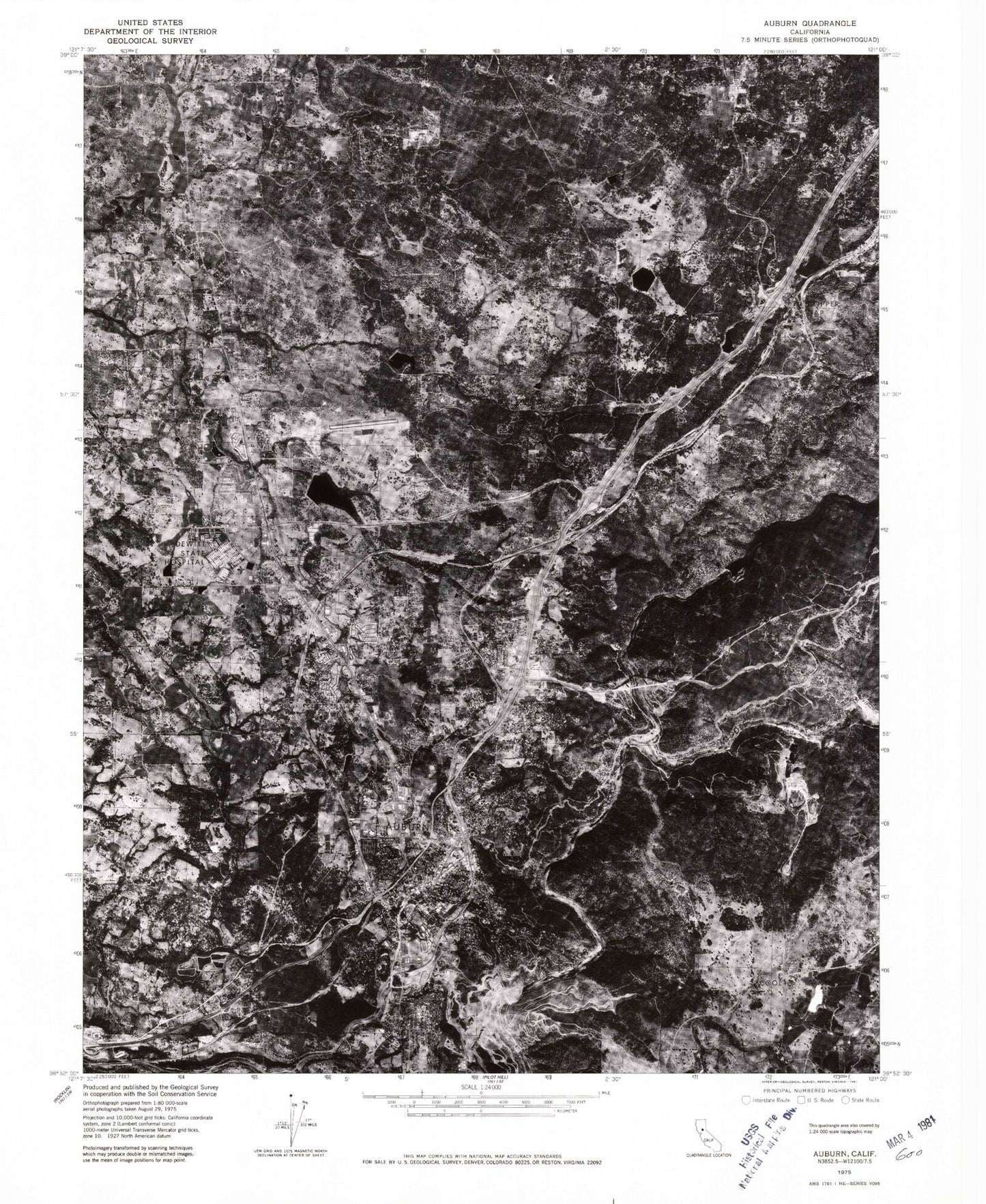
MyTopo
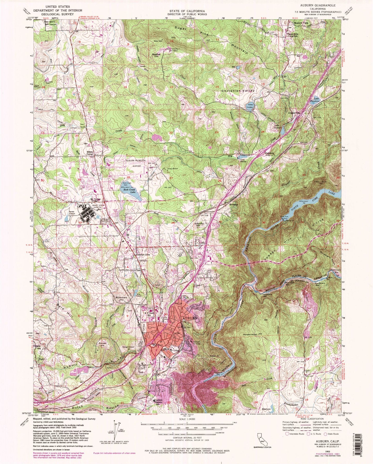
Classic USGS Auburn California 7.5'x7.5' Topo Map
Couldn't load pickup availability
Historical USGS topographic quad map of Auburn in the state of California. Typical map scale is 1:24,000, but may vary for certain years, if available. Print size: 24" x 27"
This quadrangle is in the following counties: El Dorado, Placer.
The map contains contour lines, roads, rivers, towns, and lakes. Printed on high-quality waterproof paper with UV fade-resistant inks, and shipped rolled.
Contains the following named places: Bowman Elementary School, Lake Arthur, Bald Hill, Baltimore Ravine, Bowman Canal, Bowman Feeder Canal, College of Our Lady of Mercy, Christian Valley, Cool, E V Cain Stem Charter Middle School, Gasoline Alley, Halsey Forebay, Honor Camp Number Seven, Hotaling, Lime Rock, Lone Star School (historical), Louisiana Bar, Millertown (historical), Mount Vernon Grange, Murderers Bar, Murderers Gulch, New York Bar, North Fork Dam, North Ravine, Ophir Canal, Orr Creek Dam, Placer Hills Elementary School, Pointed Rocks, Rock Creek, Rock Creek Dam, Rock Creek Lake, Salt Creek, Fiddler Green Canal, South Canal, Sugar Pine Mountain, Tamaroo Bar, Lake Theodore, Upper Bowman Canal, Warner Ravine, Wise Canal, Wise Forebay, Wise Penstock, Gold Hill Canal, Lone Star Canal, Elders Corner, Nielsburg, Mammoth Bar, Middle Fork American River, North Fork Lake, Clipper Creek, Auburn Municipal Airport, Auburn CDF Heliport, PG and E-Auburn Service Center Heliport, Auburn, Bowman, Clipper Gap, Dewitt State Hospital (historical), Duncan Hill, Highland General Hospital (historical), Ophir, Robie Point, Christian Valley 97-015 Dam, Halsey Afterbay, Halsey Forebay 97-023 Dam, Lake Arthur 97-027 Dam, Lake Theodore 97-031 Dam, Rock Creek 97-043 Dam, Sewer S Pond 5 1048 Dam, Lakewood 1322 Dam, Christian Valley School (historical), Edgemont School (historical), Alta Vista Community Charter School, Angus Hills Golf Course, Ashford Park, Auburn City Hall, Old Auburn Cemetery, Auburn District Regional Park, Sutter Auburn Faith Hospital, Auburn Hills Mobile Estates, Downtown Auburn Post Office, Auburn Recreation Park, Auburn-Placer County Library, Black Oak Golf Course, Chana High School, Golden Chain Mobile Home Park, Gold Country Fairgrounds, McCann Stadium, New Auburn Cemetery, Old Auburn Historic District, Placer County Courthouse, Placer County Historical Museum, Placer High School, Rock Creek Elementary School, Saint Josephs Catholic Church, Saint Josephs School, Veterans Memorial Hall, Cool Post Office, Northside Elementary School, North Auburn, Auburn Division, DeWitt Government Center, Auburn Waste Water Treatment Facility, Ridge Golf Course, Christian Valley Park, Spring Meadows Park, Dewitt General Hospital (historical), North Auburn Census Designated Place, City of Auburn, Auburn State Recreation Area, Auburn City Fire Department Station 1 Martin Park, Auburn City Fire Department Station 3 Maidu, Placer County Fire Department 180 Atwood Station, Placer County Fire Department Station 184 Lone Star, Auburn City Fire Department Station 2 Gietzen, El Dorado County Fire District Station 72, California Shock Trauma Air Medical Transport, Cool Quarry, Cool - Cave Valley Quarry, Newcastle Quarry, Lubeck Mansion, Placer County Jail, Foresthill Bridge, Placer Placer County Sheriff's Office, Auburn Police Department, Meadow Vista Post Office, Auburn Post Office, Bowman Post Office, Placer County Hospital Cemetery, Maidu Indian Burial Grounds, Clipper Gap Cemetery, Chinese Cemetery