MyTopo
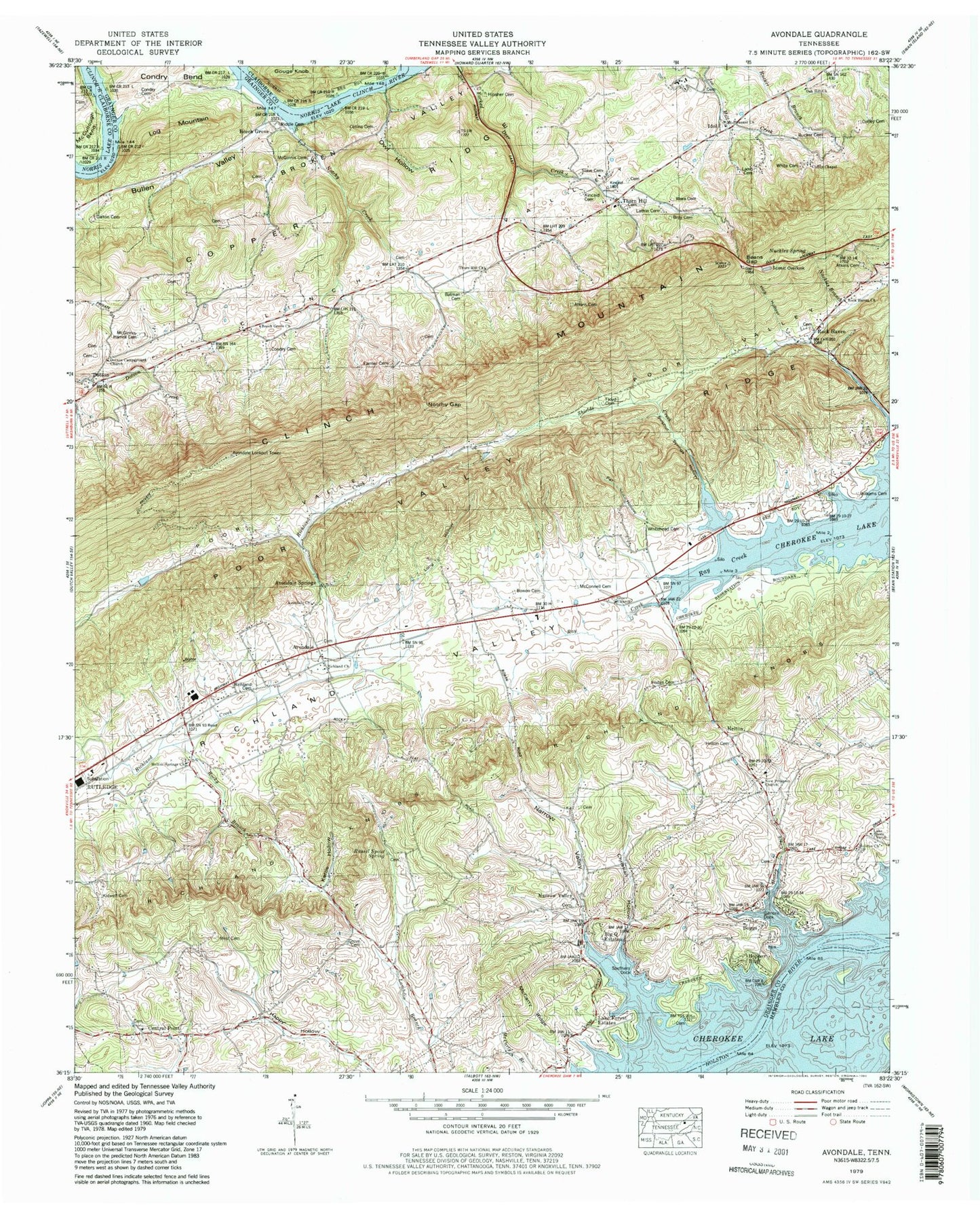
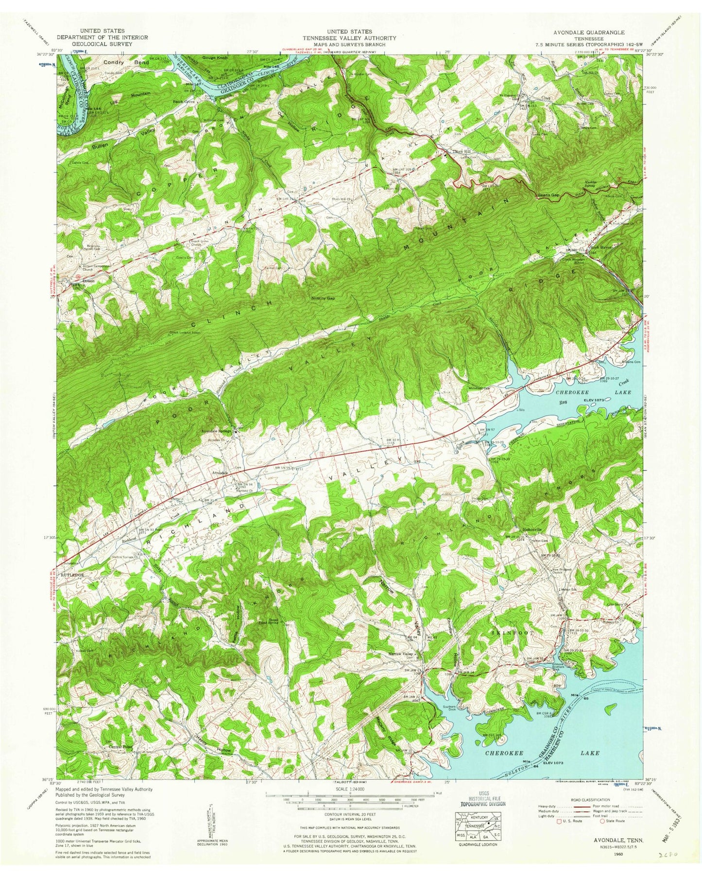
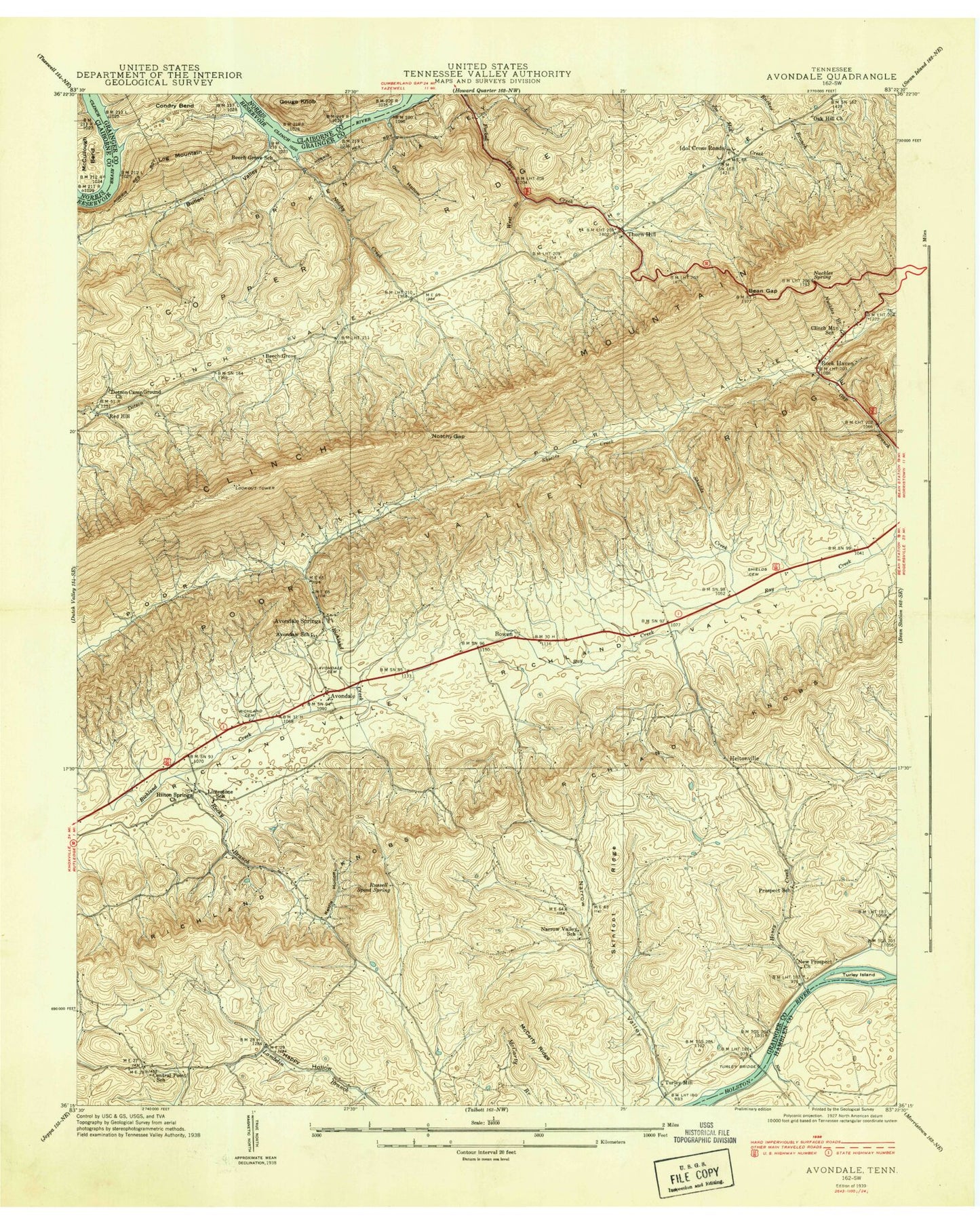
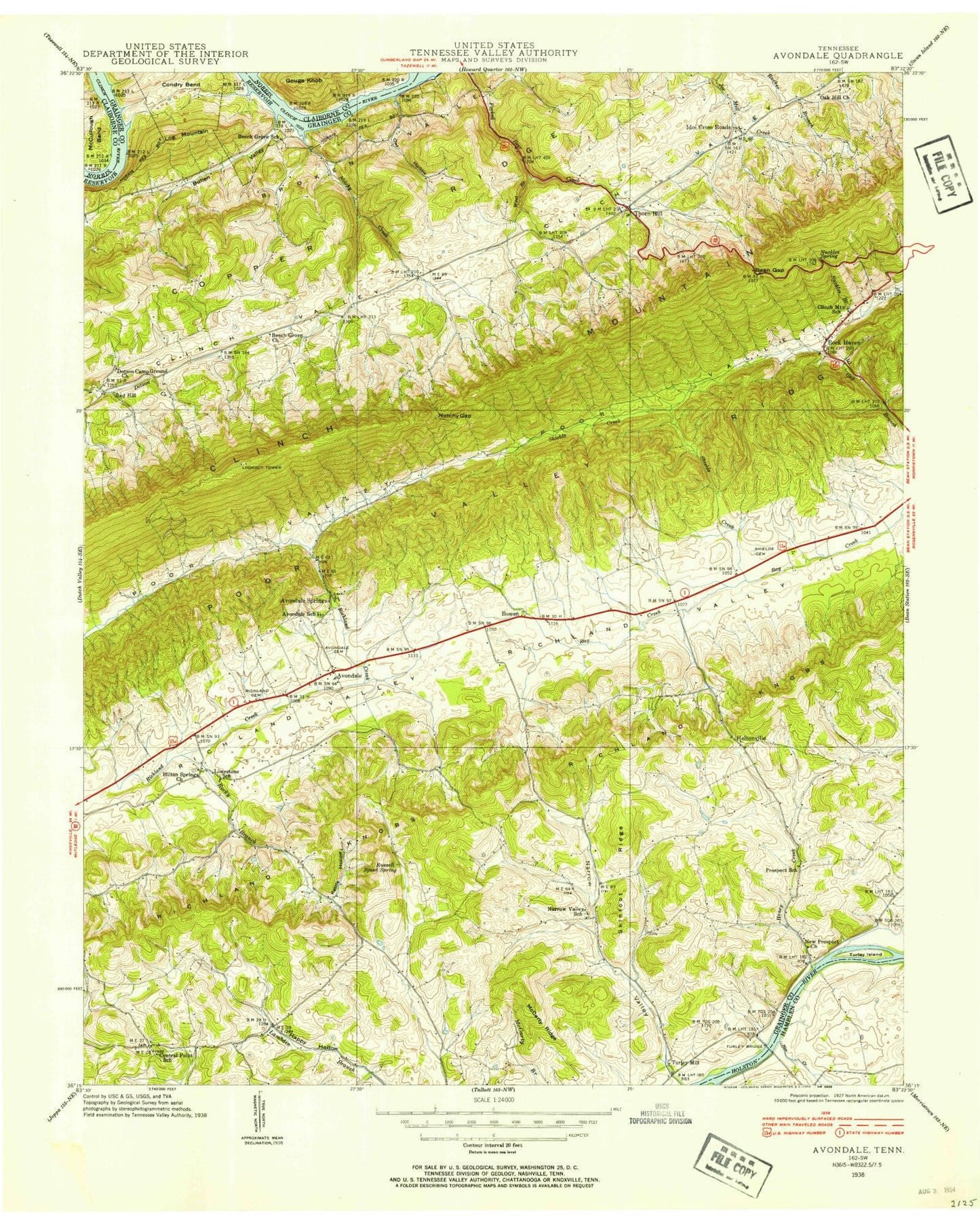
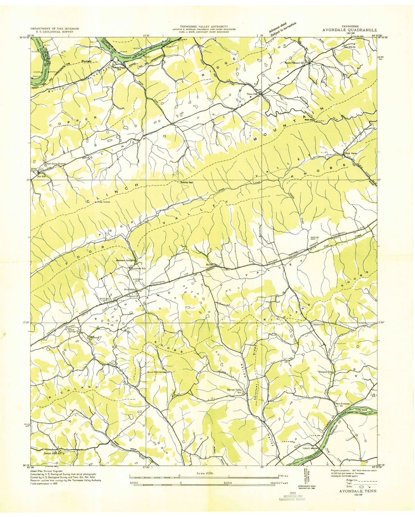
Classic USGS Avondale Tennessee 7.5'x7.5' Topo Map
Couldn't load pickup availability
Historical USGS topographic quad map of Avondale in the state of Tennessee. Typical map scale is 1:24,000, but may vary for certain years, if available. Print size: 24" x 27"
This quadrangle is in the following counties: Claiborne, Grainger, Hamblen.
The map contains contour lines, roads, rivers, towns, and lakes. Printed on high-quality waterproof paper with UV fade-resistant inks, and shipped rolled.
Contains the following named places: Shields Creek, Thorn Hill Church, Thorn Hill School, White Cemetery, Whitehead Cemetery, Williams Cemetery, Adkins Cemetery, Adkins Cemetery, Avondale Springs, Thorn Hill Gap, Broken Valley, Central Point, Christian Hollow, Clinch Mountain School, Coffey Cemetery, Condry Bend, Condry Cemetery, Condry Cemetery, Dalton Cemetery, Farmer Cemetery, Gilmore Dock, Gouge Knob, Helton Cemetery, Helton School, Helton Springs Church, Hipsher Cemetery, Holston Church, Honey Creek, Kettle Hollow, Kidwell Cemetery, Lamb Cemetery, Lathin Cemetery, McCarty Ridge, McCullough Bend, McGinnis Cemetery, McGinnis Harrell Cemetery, Narrow Valley, Narrow Valley, New Prospect Church, Notchy Creek, Notchy Gap, Nuckles Branch, Nuckles Spring, Owl Hollow, Richland Cemetery, Richland Church, Riddle Cemetery, Rock Haven, Rock Haven Church, Rocky Branch, Rucker Cemetery, Russel Spout Spring, Wolfe Lake, Wolfe Dam, Poor Valley Ridge, Southern Dock, Avondale Church, Beech Grove Church, Dotson Campground Church, Lake Shore Church, Mount Pleasant Church, Oak Hill Church, Big Q Estates, Boggs, Bowen, Hopper Bluff, Lake Forest Estates, Skinfoot Ridge, Sulphur Springs Hollow, Turley Ferry (historical), Turley Island (historical), Turley Mills (historical), Little Broken Valley, Noe Creek, Thorn Hill, Avondale, Beech Grove, Dotson, Helton, Idol, Avondale Cemetery, Avondale School (historical), Batman Cemetery, Beech Grove School (historical), Bowen Cemetery, Bray Cemetery, Central Point School (historical), Coffey Chapel, Collins Cemetery, Floyd Cemetery, Grove Cemetery, Grace Church, Kincaid Cemetery, Limestone School (historical), McConnell Cemetery, Narrow Valley School (historical), Prospect School (historical), Rhea Cemetery, Shields Cemetery, Slave Cemetery, Turley Bridge (historical), West Cemetery, Central Point Cemetery, Dotson Cemetery, Dotson School (historical), Helton Springs Cemetery, Holston Cemetery, Idol Cemetery, Narrow Valley Cemetery, New Prospect Cemetery, Big Slip, Black Sulfur Spring, Central Point Baptist Church, Free Stone Spring, Iron Water Spring, Lithia Spring, Narrow Valley Baptist Church, Red Sulfur Spring, White Sulfur Spring, Copper Ridge Point, Avondale Lookout Tower, Thorn Hill Post Office, Commissioner District 2, Thorn Hill Volunteer Fire Department, Shields Creek, Thorn Hill Church, Thorn Hill School, White Cemetery, Whitehead Cemetery, Williams Cemetery, Adkins Cemetery, Adkins Cemetery, Avondale Springs, Thorn Hill Gap, Broken Valley, Central Point, Christian Hollow, Clinch Mountain School, Coffey Cemetery, Condry Bend, Condry Cemetery, Condry Cemetery, Dalton Cemetery, Farmer Cemetery, Gilmore Dock, Gouge Knob, Helton Cemetery, Helton School, Helton Springs Church, Hipsher Cemetery, Holston Church, Honey Creek, Kettle Hollow, Kidwell Cemetery, Lamb Cemetery, Lathin Cemetery, McCarty Ridge, McCullough Bend, McGinnis Cemetery, McGinnis Harrell Cemetery, Narrow Valley, Narrow Valley, New Prospect Church, Notchy Creek, Notchy Gap, Nuckles Branch, Nuckles Spring, Owl Hollow, Richland Cemetery, Richland Church, Riddle Cemetery, Rock Haven, Rock Haven Church, Rocky Branch, Rucker Cemetery, Russel Spout Spring, Wolfe Lake, Wolfe Dam, Poor Valley Ridge, Southern Dock, Avondale Church, Beech Grove Church, Dotson Campground Church, Lake Shore Church, Mount Pleasant Church, Oak Hill Church, Big Q Estates, Boggs, Bowen, Hopper Bluff, Lake Forest Estates, Skinfoot Ridge, Sulphur Springs Hollow, Turley Ferry (historical), Turley Island (historical), Turley Mills (historical), Little Broken Valley, Noe Creek, Thorn Hill, Avondale, Beech Grove, Dotson, Helton, Idol, Avondale Cemetery, Avondale School (historical), Batman Cemetery, Beech Grove School (historical), Bowen Cemetery, Bray Cemetery, Central Point School (historical), Coffey Chapel, Collins Cemetery, Floyd Cemetery, Grove Cemetery, Grace Church, Kincaid Cemetery, Limestone School (historical), McConnell Cemetery, Narrow Valley School (historical), Prospect School (historical), Rhea Cemetery, Shields Cemetery, Slave Cemetery, Turley Bridge (historical), West Cemetery, Central Point Cemetery, Dotson Cemetery, Dotson School (historical), Helton Springs Cemetery, Holston Cemetery, Idol Cemetery, Narrow Valley Cemetery, New Prospect Cemetery, Big Slip, Black Sulfur Spring