MyTopo
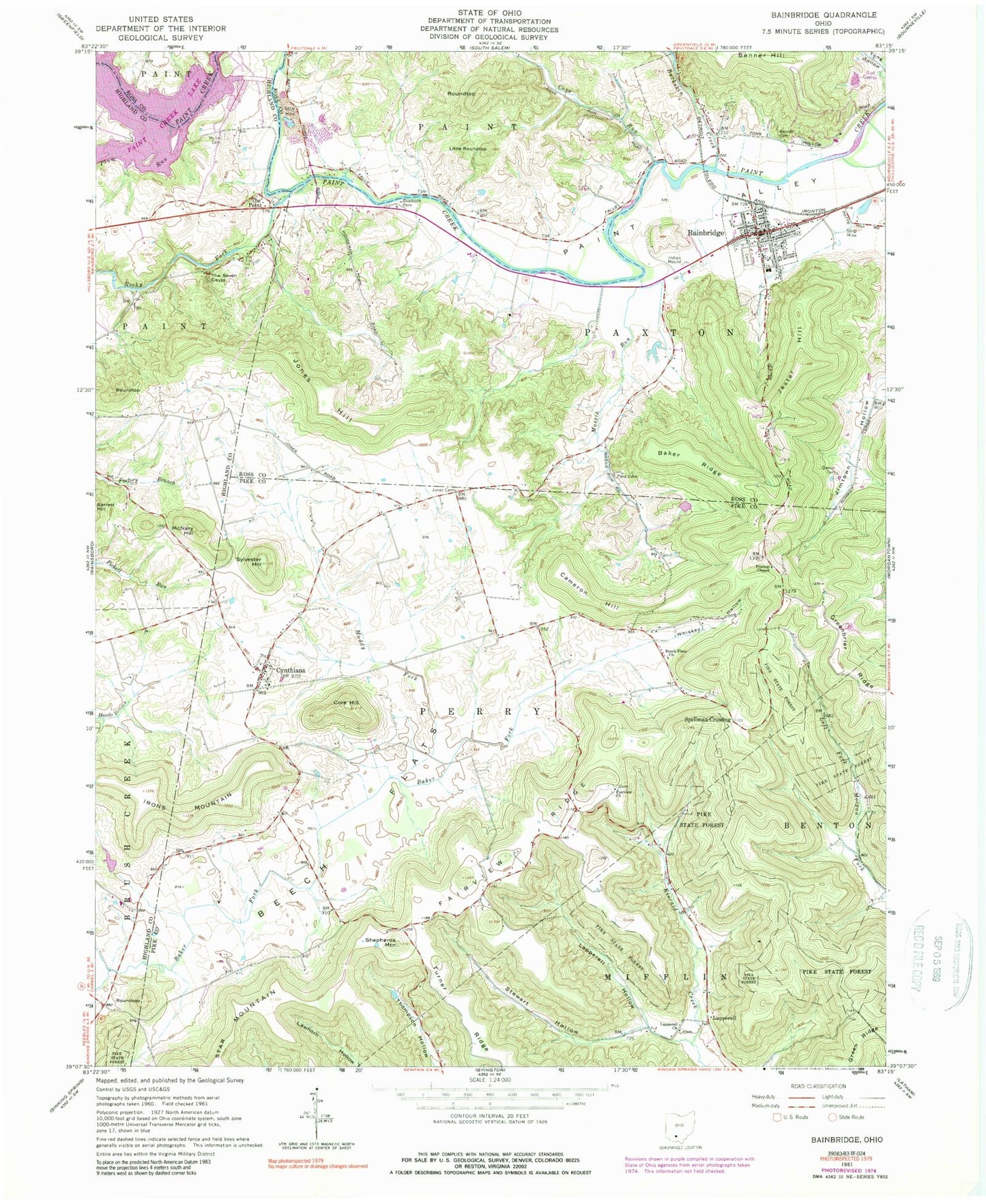
Classic USGS Bainbridge Ohio 7.5'x7.5' Topo Map
Couldn't load pickup availability
Historical USGS topographic quad map of Bainbridge in the state of Ohio. Map scale may vary for some years, but is generally around 1:24,000. Print size is approximately 24" x 27"
This quadrangle is in the following counties: Highland, Pike, Ross.
The map contains contour lines, roads, rivers, towns, and lakes. Printed on high-quality waterproof paper with UV fade-resistant inks, and shipped rolled.
Contains the following named places: Bainbridge, Bainbridge Cemetery, Bainbridge Church of Christ, Bainbridge Elementary School, Bainbridge Fire Department, Bainbridge Post Office, Bainbridge Presbyterian Church, Bainbridge United Methodist Church, Baker Ridge, Beech Flats, Beech Flats Church, Benner Cemetery, Benner School, Buckskin Creek, Cameron Hill, Cameron School, Core Hill, Cove Run, Cynthiana, Cynthiana Cemetery, Cynthiana Census Designated Place, Cynthiana Post Office, Fairview Cemetery, Fairview Church, Fairview Ridge, Fairview School, Garner Cemetery, Greenbrier Ridge, Haas Airport, Housemantown School, Hulitt Cemetery, Hulitt School, Jackson School, Jester Hill, Jones Cemetery, Jones Hill, Lapperell, Lapperell Cemetery, Lapperell Hollow, Lapperell Post Office, Lapperell United Brethren Church, Little Roundtop, Massie Run, McNary Hill, Muddy Fork, Pake Cemetery, Paxton Township EMS, Pickett Run Farm, Pine Top School, Pinetop Chapel, Plum Run, Rocky Fork, Roundtop, Shepherds Mountain, Spellman Crossing, Spring Valley Farms, Stewart Hollow, Sylvester Hill, The Point, The Seven Caves, Tong Hollow School, Township of Paxton, Township of Perry, Turner Ridge, Valley Vista Airport, Valley Vista Golf Course, Village of Bainbridge, West School, Whiskey Hollow, ZIP Codes: 45612, 45624