MyTopo
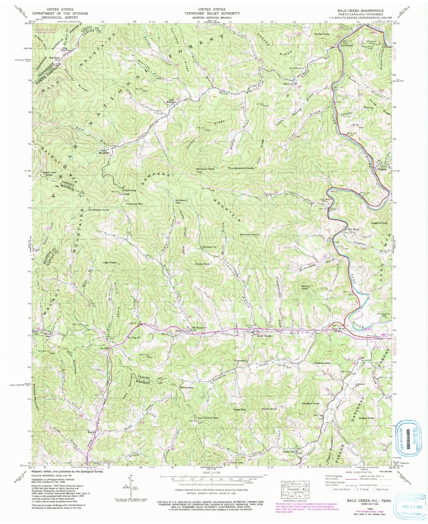
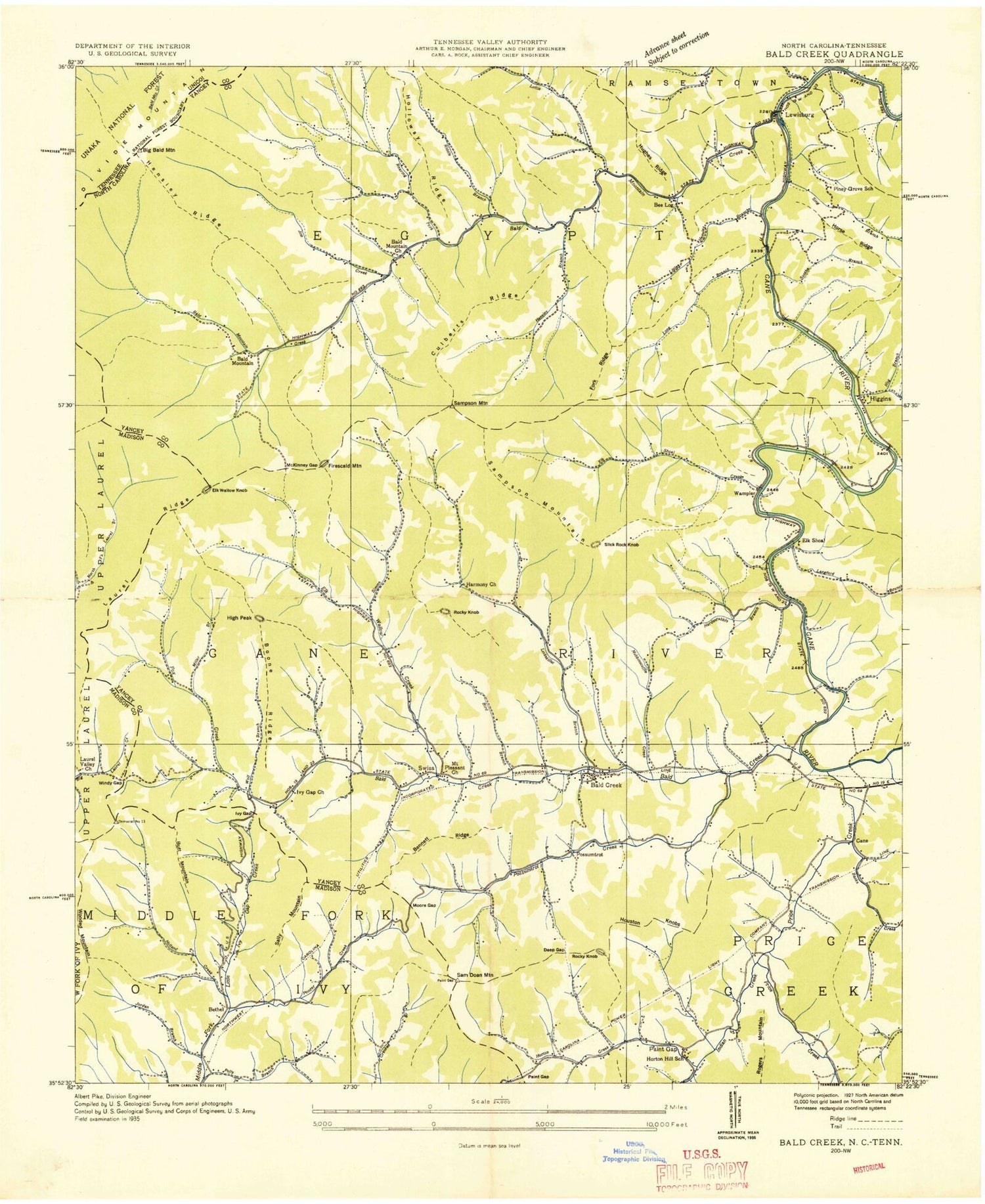
Classic USGS Bald Creek North Carolina 7.5'x7.5' Topo Map
Couldn't load pickup availability
Historical USGS topographic quad map of Bald Creek in the states of North Carolina, Tennessee. Typical map scale is 1:24,000, but may vary for certain years, if available. Print size: 24" x 27"
This quadrangle is in the following counties: Madison, Unicoi, Yancey.
The map contains contour lines, roads, rivers, towns, and lakes. Printed on high-quality waterproof paper with UV fade-resistant inks, and shipped rolled.
Contains the following named places: Bald Creek, Bald Mountain Church, Bald Mountain Creek, Banks Creek, Big Bald, Boone Ridge, Culbert Ridge, Cynthia Branch, Deep Gap, Edwards Cemetery, Elk Shoal Cemetery, Elk Shoal Creek, Elk Wallow Creek, Feds Branch, Fender Cemetery, Fork Ridge, Fox Creek, Hardscrabble Branch, Harmony Church, Harris Branch, Hawk Branch, Hensley Branch, Hensley Ridge, Higgins Creek, Horton Creek, Indian Creek, Ivy Gap, Ivy Gap Branch, Ivy Gap Church, Jim Creek, Jordan Branch, Langford Branch, Lewisburg, Lickskillet Branch, Little Creek, Little Hensley Branch, Locust Rough Ridge, Long Branch, Lottie Creek, McKinney Gap, Medrith Branch, Middle Fork Hawk Branch, Miller Branch, Moore Gap, Mount Pleasant Church, North Fork Hawk Branch, Nubbinscuffle Creek, Paint Gap, Paint Gap, Patsy Creek, Phillips Cemetery, Polly Branch, Ponder Creek, Possumtrot Creek, Prather Gap, Price Creek, Riddle Branch, Roaring Fork, Robinson Cemetery, Sam Doane Mountain, Sampson Gap, Sampson Peak, Seng Branch, Shepherd Branch, Simms Fork, South Fork Hawk Branch, Sweet Branch, Whittington Cemetery, Wildcat Hollow, Windy Gap, Wolf Branch, Mars Hill Reservoir Dam, Mars Hill Reservoir, Bald Creek Elementary School, Bee Log Elementary School, Hensley (historical), Cane River High School, Laurel Valley School, Elk Wallow Church, Piney Grove School, Bald Creek, Bald Mountain, Bee Log, Bethel, Butt Mountain, Cane, Elk Shoal, Elk Wallow Knob, Firescald Mountain, Grassy Knob, Higgins, Higgins Knob, High Peak, Holland Creek, Houston Knob, Possumtrot, Renfro Knob, Rocky Knob, Rocky Knob, Sally Mountain, Sampson Mountain, Slickrock Knob, Snake Knob, Swiss, Thunderstruck Knob, Upper Haw Knob, Wooded Mountain, Cane River, Township of Cane River, Township of Egypt, West Yancey Volunteer Fire Department Station 2, Egypt - Ramseytown Volunteer Fire Department Station 1, West Yancey Volunteer Fire Department Station 1, Appalachian National Scenic Trail, Slipper Spur, Big Stamp