
MyTopo
Classic USGS Bangor Pennsylvania 7.5'x7.5' Topo Map
Couldn't load pickup availability
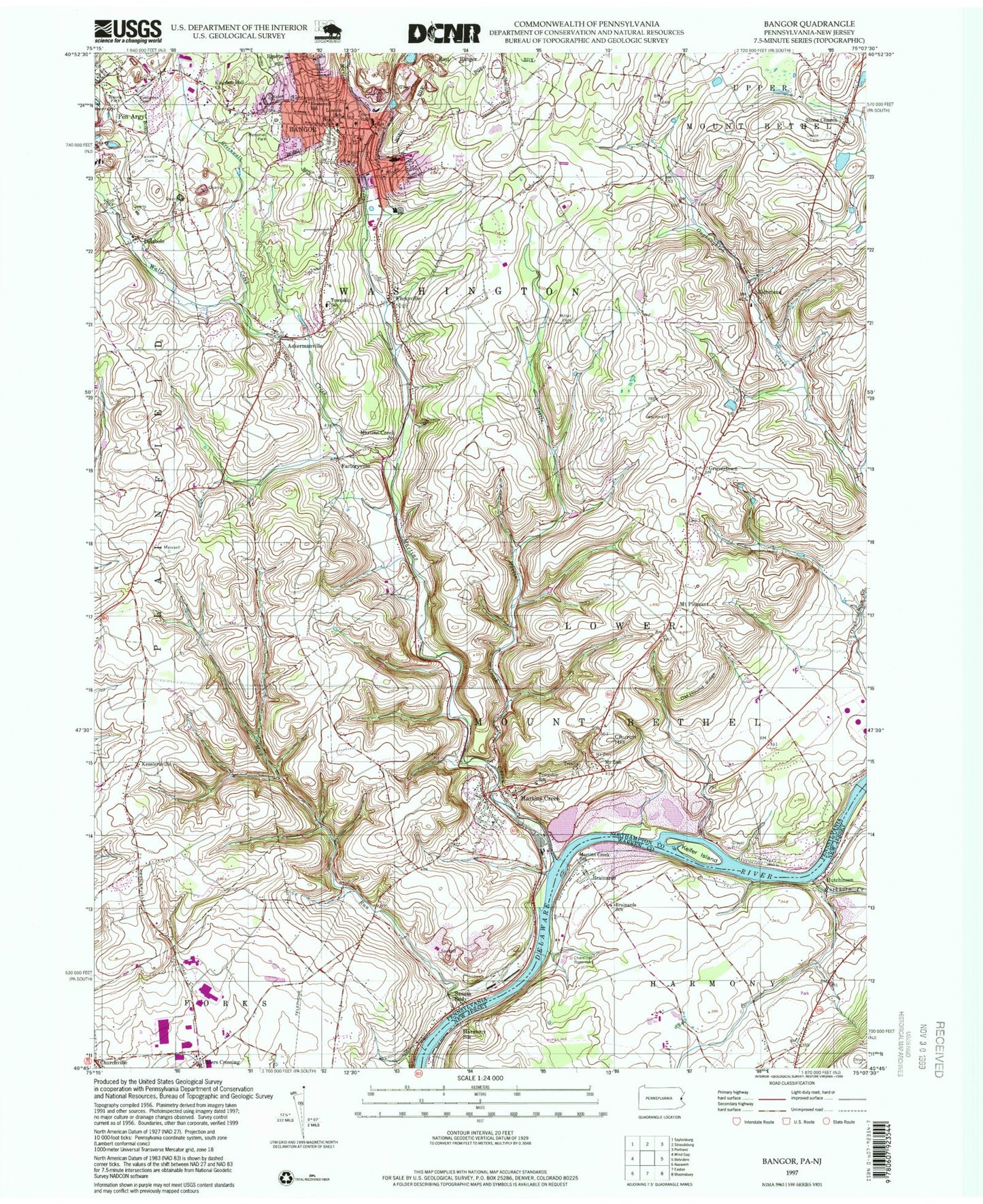
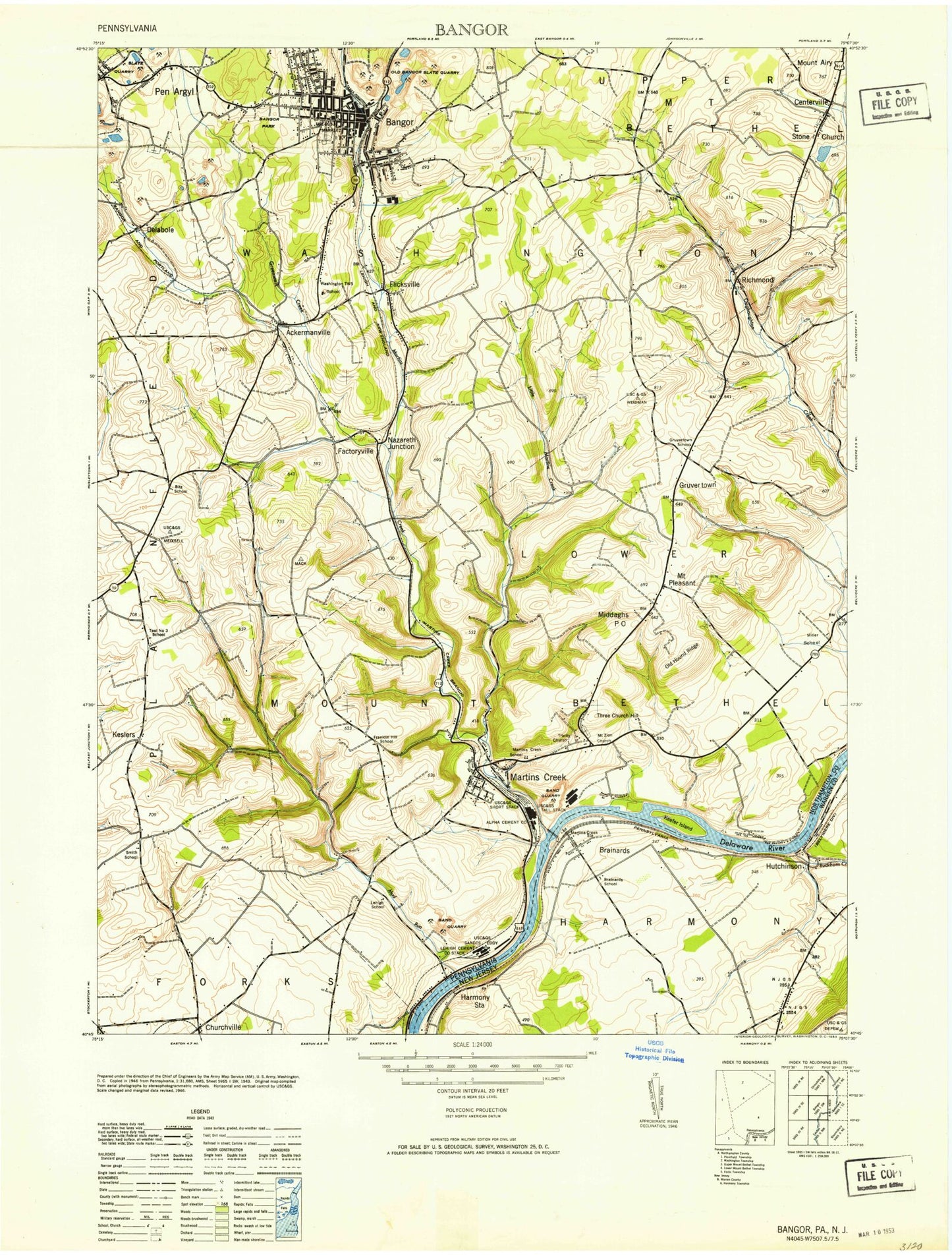
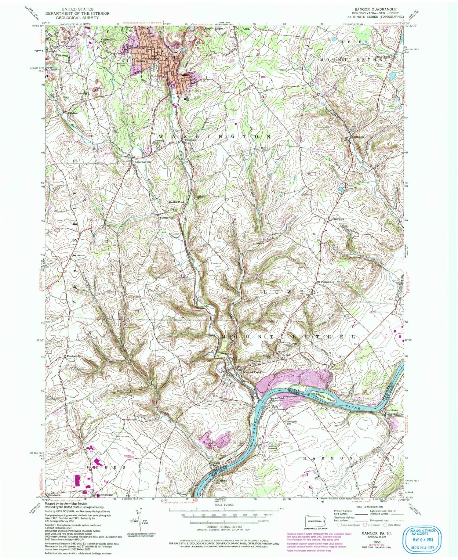
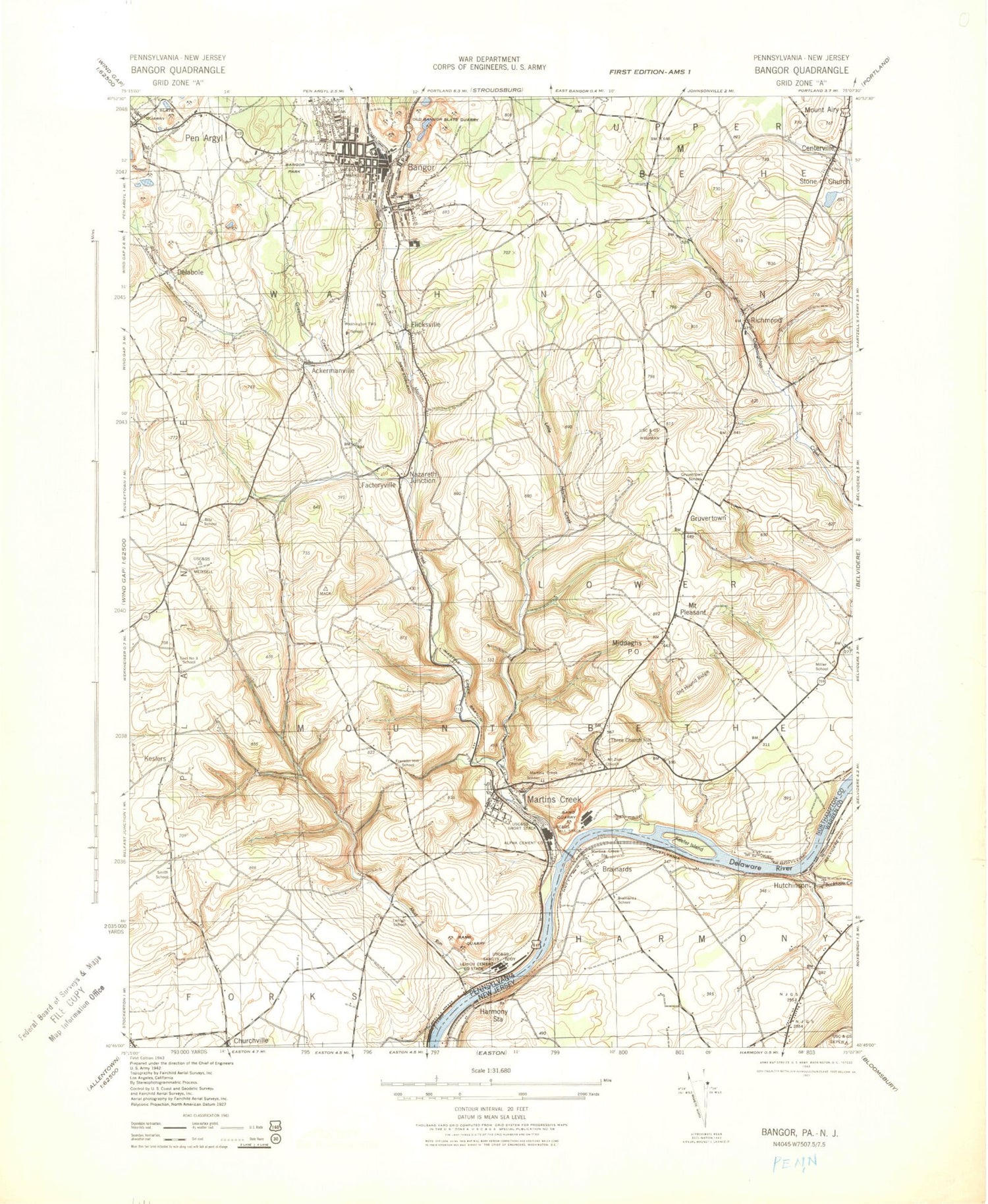
Historical USGS topographic quad map of Bangor in the states of Pennsylvania, New Jersey. Typical map scale is 1:24,000, but may vary for certain years, if available. Print size: 24" x 27"
This quadrangle is in the following counties: Northampton, Warren.
The map contains contour lines, roads, rivers, towns, and lakes. Printed on high-quality waterproof paper with UV fade-resistant inks, and shipped rolled.
Contains the following named places: Ackermanville, Mount Airy, Bangor, Church Hill, Delabole, Saint Elizabeths Cemetery, Fairview Cemetery, Flicksville, Greenwalk Creek, Kesslersville, Kingdom Hall Church, Lincoln School, Little Martins Creek, Martins Creek, Memorial Park, Miller Cemetery, Mount Pleasant, Church Hill Cemetery, Mount Zion Church, Mud Run, Old Hound Ridge, Our Lady of Mount Carmel School, Roosevelt School, Saint Johns Cemetery, Trinity Church, Union Cemetery, Waltz Creek, Weona Park, Uhlers Crossing, Gap View Airport, Washington School, Myers School, Thomas School, Fells School, Hartzell School, Valley School (historical), Miller School, Bethel School (historical), Farrow School, Bitz School, Teel School, Smith School, Shimerville, Franklin Hill School, Lehigh School, Sandts Eddy, Sandts Eddy Station (historical), Keifer Island, Martins Creek, Stone Church, Clistowackin, Factoryville, Gruvertown, Martins Creek Junction, Richmond, Frytown, Mill Dam, Mill Dam, Washington Township Elementary School, Bangor Elementary School, Uttsville, New Village, Harmony Ferry (historical), Martins Creek Ferry (historical), Depuy Ferry (historical), Martins Creek Station (historical), Uhlers Station, Pius X High School, Borough of Bangor, Township of Lower Mount Bethel, Township of Washington, Ackermanville Census Designated Place, Martins Creek Census Designated Place, Stoney Ridge Horse Farm, Washington Township Volunteer Fire Company Station 38, Lower Mount Bethel Sandt's Eddy Fire Company Station 26, Bangor Fire Department Liberty Fire Station 30, Bangor Fire Department Rescue Fire Company Station 30, Bangor Fire Department Second Ward Station 30, Plainfield Township Volunteer Fire Company / Plainfield Township Ambulance Corps Substation, Bangor Post Office, Martins Creek Post Office, Bangor Police Department, Washington Township Police Department, Brainards, Brainards School, Buckhorn Creek, Harmony Station, Hutchinson, Martins Creek Station, Markle Airport, Brainards Census Designated Place, Harmony Census Designated Place, Ackermanville, Mount Airy, Bangor, Church Hill, Delabole, Saint Elizabeths Cemetery, Fairview Cemetery, Flicksville, Greenwalk Creek, Kesslersville, Kingdom Hall Church, Lincoln School, Little Martins Creek, Martins Creek, Memorial Park, Miller Cemetery, Mount Pleasant, Church Hill Cemetery, Mount Zion Church, Mud Run, Old Hound Ridge, Our Lady of Mount Carmel School, Roosevelt School, Saint Johns Cemetery, Trinity Church, Union Cemetery, Waltz Creek, Weona Park, Uhlers Crossing, Gap View Airport, Washington School, Myers School, Thomas School, Fells School, Hartzell School, Valley School (historical), Miller School, Bethel School (historical), Farrow School, Bitz School, Teel School, Smith School, Shimerville, Franklin Hill School, Lehigh School, Sandts Eddy, Sandts Eddy Station (historical), Keifer Island, Martins Creek, Stone Church, Clistowackin, Factoryville, Gruvertown, Martins Creek Junction, Richmond, Frytown, Mill Dam, Mill Dam, Washington Township Elementary School, Bangor Elementary School, Uttsville, New Village, Harmony Ferry (historical), Martins Creek Ferry (historical), Depuy Ferry (historical), Martins Creek Station (historical), Uhlers Station, Pius X High School, Borough of Bangor, Township of Lower Mount Bethel, Township of Washington, Ackermanville Census Designated Place, Martins Creek Census Designated Place, Stoney Ridge Horse Farm, Washington Township Volunteer Fire Company Station 38, Lower Mount Bethel Sandt's Eddy Fire Company Station 26, Bangor Fire Department Liberty Fire Station 30, Bangor Fire Department Rescue Fire Company Station 30, Bangor Fire Department Second Ward Station 30, Plainfield Township Volunteer Fire Company / Plainfield Township Ambulance Corps Substation, Bangor Post Office, Martins Creek Post Office, Bangor Police Department, Washington Township Police Department, Brainards, Brainards School, Buckhorn Creek, Harmony Station, Hutchinson, Martins Creek Station, Markle Airport, Brainards Census Designated Place, Harmony Census Designated Place, Ackermanville, Mount Airy, Bangor, Church Hill, Delabole, Saint Elizabeths Cemetery, Fairview Cemetery, Flicksville, Greenwalk Creek, Kesslersville, Kingdom Hall Church, Lincoln School, Little Martins Creek, Martins Creek, Memorial Park, Miller Cemetery, Mount Pleasant, Church Hill Cemetery, Mount Zion Church, Mud Run, Old Hound Ridge, Our Lady of Mount Carmel School, Roosevelt School, Saint Johns Cemetery, Trinity Church, Union Cemetery, Waltz Creek, Weona Park, Uhlers Crossing, Gap View Airport, Washington School, Myers School, Thomas School, Fells School, Hartzell School, Valley School (historical), Miller School, Bethel School (historical), Farrow School, Bitz School, Teel School, Smith School, Shimerville, Franklin Hill School, Lehigh School, Sandts Eddy, Sandts Eddy Station (historical), Keifer Island, Martins Creek, Stone Church