MyTopo
USGS Classic Baraboo Wisconsin 7.5'x7.5' Topo Map
Couldn't load pickup availability
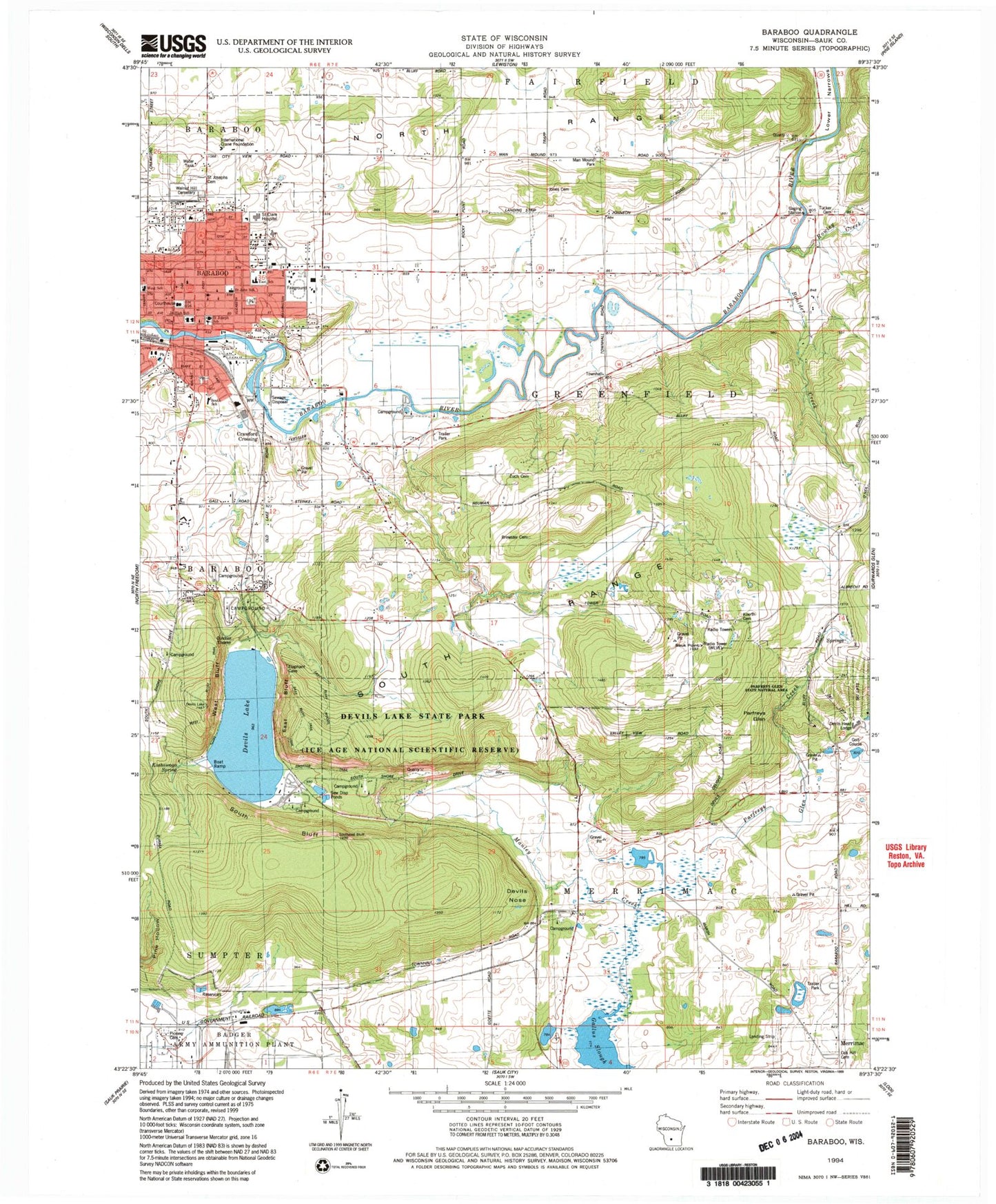
Historical USGS topographic quad map of Baraboo in the state of Wisconsin. Scale: 1:24000. Print size: 24" x 27"
This quadrangle is in the following counties: Sauk.
The map contains contour lines, roads, rivers, towns, lakes, and grids including latitude / longitude and UTM / MGRS. Printed on high-quality waterproof paper with UV fade-resistant inks.
Contains the following named places: Baraboo, Bluff Trail, Boulder Creek, Brewster Cemetery, Devils Head Lodge, Devils Lake, Devils Lake State Park, Devils Nose, East Bluff, East Bluff Trail, East Bluff Woods Trail, East Elementary School, Gallus Slough, Grottos Trail, International Crane Foundation, Jones Cemetery, Koerth Cemetery, Koshawago Spring, Lower Narrows, Man Mound Park, Manley Creek, North Range, Oak Hill Cemetery, Parfreys Glen, Parfreys Glen Creek, Rowley Creek, Saint Clare Hospital, Saint John's Lutheran School, Saint Joseph's Catholic School, Saint Josephs Cemetery, Sauk Point, South Bluff, Al Behrman Elementary School, Tucker Cemetery, Walnut Hill Cemetery, West Bluff, West Elementary - Kindergarten Center, Zuch Cemetery, South Bluff Basin, East Bluff Basin, Griegol Gulch, Roznos Meadow, Crawford Crossing, Saint Clare Hospital Heliport, WOLX-FM (Baraboo), City of Baraboo, Town of Greenfield, Town of Merrimac, Waterworks WP226 Dam, 572 Reservoir, Linen Mill Dam, 583 Reservoir, Oak Street Dam, 564 Reservoir, Advent Christian Church (historical), Advent Christian New Life Community Church, Baraboo City Hall, Baraboo Civic Center, Baraboo Golf Club, Baraboo Junior High School, Baraboo Post Office, Baraboo Public Library, Campbell Park, Chapel Hill School (historical), City View School (historical), Deppe Park, Devils Head Ski Resort, Emanuel United Methodist Church, Broadway Park, Emmanuel Evangelical Church (historical), First Baptist Church, First Church of Christ Scientist, First Congregational Church, First Presbyterian Church, First United Methodist Church, Glenville School (historical), Gospel Tabernacle (historical), Langer Park, Man Mound School (historical), Northern Lights Campground, North Shore Shelter, Parkview School (historical), Parkway Wesleyan Church, Pierce Park, Saint Johns Evangelical Lutheran Church, Saint Joseph Catholic Church, Saint Marys-Ringling Hospital (historical), Saint Pauls Lutheran Church, Sauk County Courthouse, Sauk County Fairgrounds, Sauk County Historical Museum, Second Ward School (historical), Seventh Day Adventist Church, Sunny Hill School (historical), Sunset View School (historical), Sunshine Valley School (historical), Trintiy Episcopal Church, Weber Park, Wesleyan Methodist Church (historical), West Bluff Trail, Feltz Basin, Hanson Basin, Johnson Ponds, Ott Basin, Steinke Basin, Devil's Lake Oak Forest State Natural Area, East Bluff State Natural Area, Parfrey's Glen State Natural Area, South Bluff/Devil's Nose State Natural Area, Maple Bluff Estates, Baraboo Fire Department, Baraboo District Ambulance Service, Baraboo Wastewater Treatment Plant, Prairie Hill McDaniel Field, Baraboo Police Department, Pecks Prairie, Sauk County Waterfowl Production Area