MyTopo
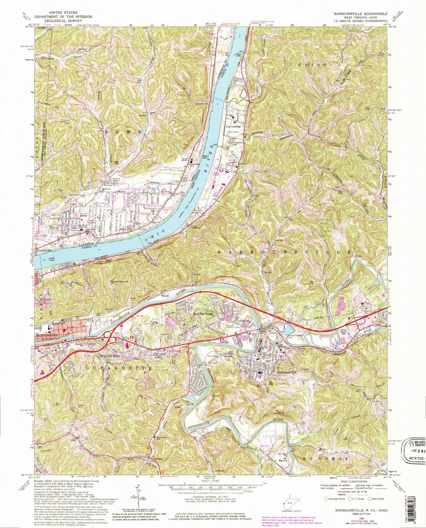
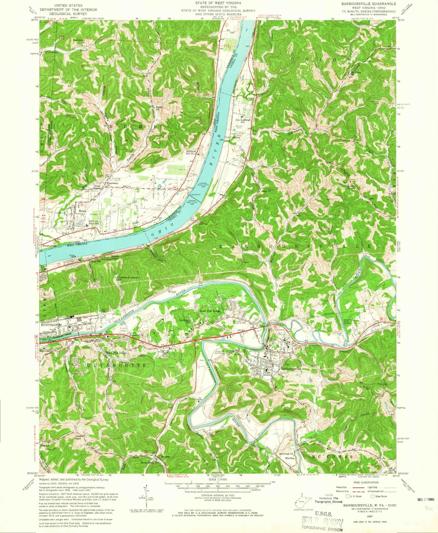
Classic USGS Barboursville West Virginia 7.5'x7.5' Topo Map
Couldn't load pickup availability
Historical USGS topographic quad map of Barboursville in the states of West Virginia, Ohio. Typical map scale is 1:24,000, but may vary for certain years, if available. Print size: 24" x 27"
This quadrangle is in the following counties: Cabell, Lawrence.
The map contains contour lines, roads, rivers, towns, and lakes. Printed on high-quality waterproof paper with UV fade-resistant inks, and shipped rolled.
Contains the following named places: Altizer School (historical), Big Gut Branch, Booten Creek, Cyrus Creek, Davis Creek, Davis Creek School (historical), Edens Branch, Elmwood Church, Faith Church, Fetty School (historical), Grace Church, Guiding Light Church, Halls Chapel, Herrenkohl Cemetery, Holland Creek, Johnson Missionary Church, Left Fork Davis Creek, Lewis Memorial Church, Little Sevenmile Creek, Melissa, Merritts Creek, Mill Creek, Mount Union Church, Mud River, Oaklawn Memorial Park, Olive Baptist Church, Pea Ridge, Ridgelawn Memorial Park, Right Fork Davis Creek, Russell Creek, Sevenmile Creek, Sunset Chapel, Susie Chapel, Tanyard Branch, Threemile Creek, White Chapel Memorial Gardens, Ninemile Creek, Barboursville, Cox Landing, East Pea Ridge, Martha, West Pea Ridge, Wilson, Lake of Eden Dam, Lake of Eden, Melody T Ranch Lake Dam, Melody T Lake, Glenbrier Country Club, Guyan Country Club, Robert Newlon Field, Lesage Post Office, Altizer, Altizer Elementary School, Altizer Park, American Hospital for Rehabilitation (historical), Barboursville Baptist Church, Barboursville Branch Cabell County Library, Barboursville Elementary School (historical), Barboursville High School (historical), Barboursville Middle School, Barboursville Post Office, Barboursville State Hospital (historical), Bates Memorial Presbyterian Church, Cabell County Career Technology Center, Campbell Park, Church of Christ, Cox Landing Elementary School, Cox Landing Middle School (historical), Coxs Landing United Methodist Church, East Hills Mall Shopping Center, Eastern Heights Shopping Center, Edgemont, Farmdale Church of Christ, First United Methodist Church, Guyan Estates, Hillview, Huntington Mall Shopping Center, Knob Hill Golf Club (historical), Kuhn Memorial Presbyterian Church, Kyle Field Industrial Park, Martha Elementary School, Orchard Hill Country Club, Pea Ridge Elementary School (historical), Pea Ridge Plaza Shopping Center, Riverview United Methodist Church, Saint Andrews Episcopal Church, Steele Memorial United Methodist Church, Tallwood Acres, Timberlake, Pea Ridge, District 3, HealthSouth Rehabilitation Hospital, Davis Creek Elementary School, Nichols Elementary School, Barboursville Elementary School (historical), Voc Tech Adult Programs School, Pea Ridge Census Designated Place, Village of Barboursville, Barboursville School, Covenant School, Barboursville Volunteer Fire Department, Ohio River Road Volunteer Fire Department, Prestera Center Crisis Unit West, Cabell County Emergency Medical Services Station 4, Lesage Census Designated Place, Robert L Shell Juvenile Center, Guyan Golf and Country Club, Orchard Hills Golf and Country Club, Riveria Country Club Golf Course, Western Regional Jail, Guyandotte River Overpass, Daniel Memorial Bridge, William Turman Bridge, Russell Creek Bridge, General McComas Bridge, White Chapel Bridge, Indian Meadows Bridge, David Ricky Memorial Bridge, Cinemark Huntington Mall, Cox Landing Branch Library, Barboursville Police Department, West Virginia State Police Troop 5 - Huntington Detachment, Barboursville Mall Post Office, Cabell County Emergency Medical Services Station 8, Robert L Shell Juvenile Center, Beulah Church, Fairland High School, Finley Church, Holiday Drive Church, Little Paddy Creek, McCall Creek, Middle Paddy Creek, Missionary Church, Mount Pisgah Church, Rome - Proctorville Cemetery, Rose of Sharon Church, Submissive Church, Michaels Run, Hagley Creek, Gillette, Lakeland, Riverside Terrace, Lock and Dam Number 27 (historical), Lock, Fair Place, Le Mae, Brookover Estates, Guthrie, Riverview, Gardner Terrace, Quaker Bottom, Belle Court, Northwood, Cranford, Riverview Estates, Miller Estates, Home Park, Mott, Lawrence County Fairgrounds, Plantation Estates, Fairland, Rome, Paddy Creek, Fairland School Number 4, Fairland East Elementary School, Beulah Baptist Cemetery, Rome Volunteer Fire Department Station 1, Lawrence County Emergency Medical Services Rome Station