MyTopo
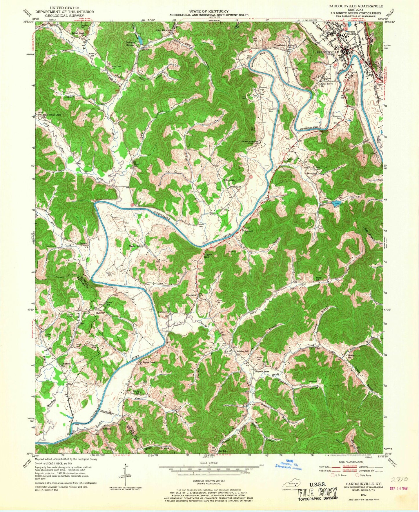
Classic USGS Barbourville Kentucky 7.5'x7.5' Topo Map
Couldn't load pickup availability
Historical USGS topographic quad map of Barbourville in the state of Kentucky. Map scale is 1:24000. Print size is approximately 24" x 27"
This quadrangle is in the following counties: Knox, Whitley.
The map contains contour lines, roads, rivers, towns, and lakes. Printed on high-quality waterproof paper with UV fade-resistant inks, and shipped rolled.
Contains the following named places: Adam and Eve Cemetery, Adams Cemetery, Apple Grove (historical), Bain Branch, Barbourville, Barbourville Cemetery, Barbourville Division, Barbourville Fire Department Station 1, Barbourville Police Department, Barbourville Post Office, Bennett Branch, Big Indian Creek, Brown Hollow, Bryant Cemetery, Bryants Store, Bryants Store Division, Bryants Store Post Office, Bull Run, Catron Branch, City of Barbourville, Clate Church, Clate Post Office (historical), Clate School (historical), Dishman Post Office (historical), Dishman Springs, Dishman Springs Lake, Engle Hollow, Engle School (historical), Evans Cemetery, Faulkner Cemetery, Fighting Creek, Flat Creek, Flat Lick School (historical), Floyd Cemetery, Fourmile Branch, Fuson Cemetery, Gausdale, Glasscock Cemetery, Goodin Creek, Goodin School (historical), Hampton Cemetery, Hampton School, Hawn Cemetery, Helton Branch, Henderson Chapel, Hubb Cemetery, Hubbs Creek, Hubbs Creek School (historical), Hubbs Post Office (historical), Indian Creek, Indian Creek Baptist Church, Indian Creek Cemetery, Indian Creek Post Office (historical), Indian Springs Country Club, John W Campbell Cemetery, Ketchen Cemetery, Ketchen School (historical), Killian Cemetery, King Post Office (historical), King School (historical), Kingtown, Knox County Ambulance Service, Knox County Sheriff's Office, Lake School (historical), Law School, Lay School (historical), Lewellen Branch, Lindsay Post Office (historical), Little Indian Creek, Little Indian Creek Church, Little Poplar Creek, Little Poplar Creek Church, Little Poplar Creek Fire Department, Logan Gap, Logan Hollow, Low Hollow, Lowe Hollow, Mackey Bend, Mackey Bend Ferry (historical), Mackey Bend School (historical), Mackey Cemetery, Mayhew Cemetery, Mays Cemetery, Meadow Creek, Miles Cemetery, Mossy Gap, New Covenant Church, New Hope Church, Old Poplar Creek Church, Owens Branch, Owens Cemetery, Paint Hill Baptist Church, Paint Hill Baptist Church (historical), Permon, Permon Post Office (historical), Permon School, Pine Post Office (historical), Pleasant Grove Church, Powell Cemetery, Powers Branch, Prichard Branch, Prichard Cemetery, Prichard Church, Providence, Punch Hollow, Reese School (historical), Richland Creek, Ricket Branch, River Church, Sharp Cemetery, Smith Hollow, Smith-Hicks Cemetery, Smokey Creek, Stony Fork, Stony School (historical), Sugartree Branch, Swan Lake, Swan Lake Post Office (historical), Swan Pond, Swan Pond Baptist Church, Swan Pond Creek, Swanpond, Swanpond Post Office (historical), Terrell Cemetery, Union College, Walker Cabin (historical), Walker Memorial State Park, Warfield Cemetery, West Cemetery, Woodbine Fire and Rescue Department Station 2, WYWY-FM (Barbourville)