MyTopo
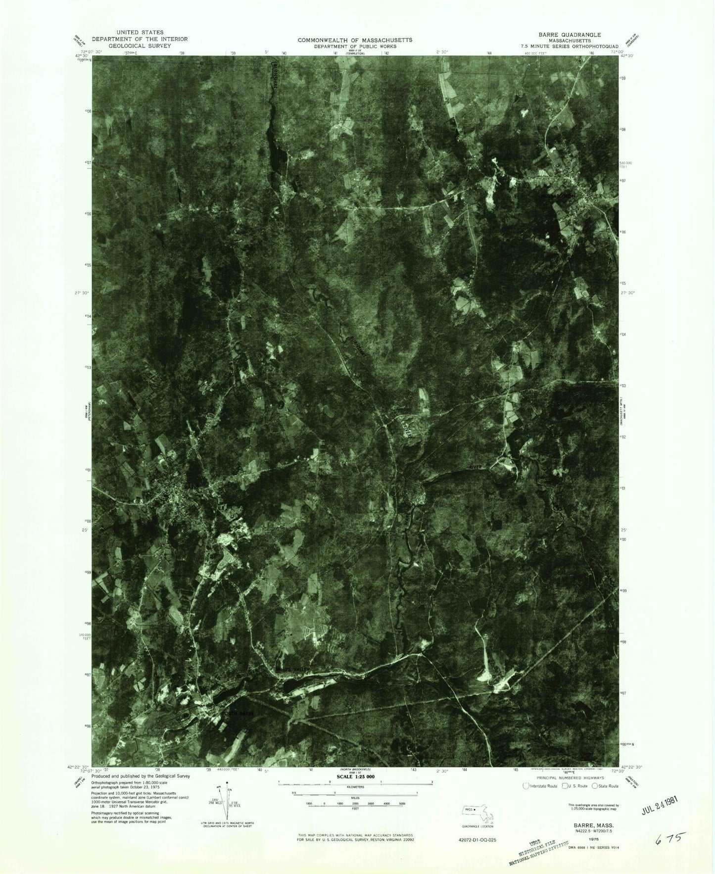
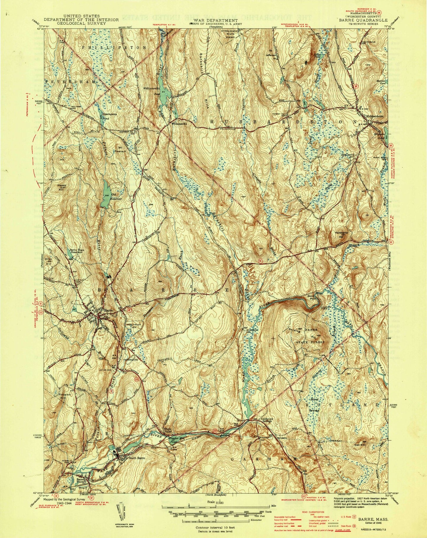
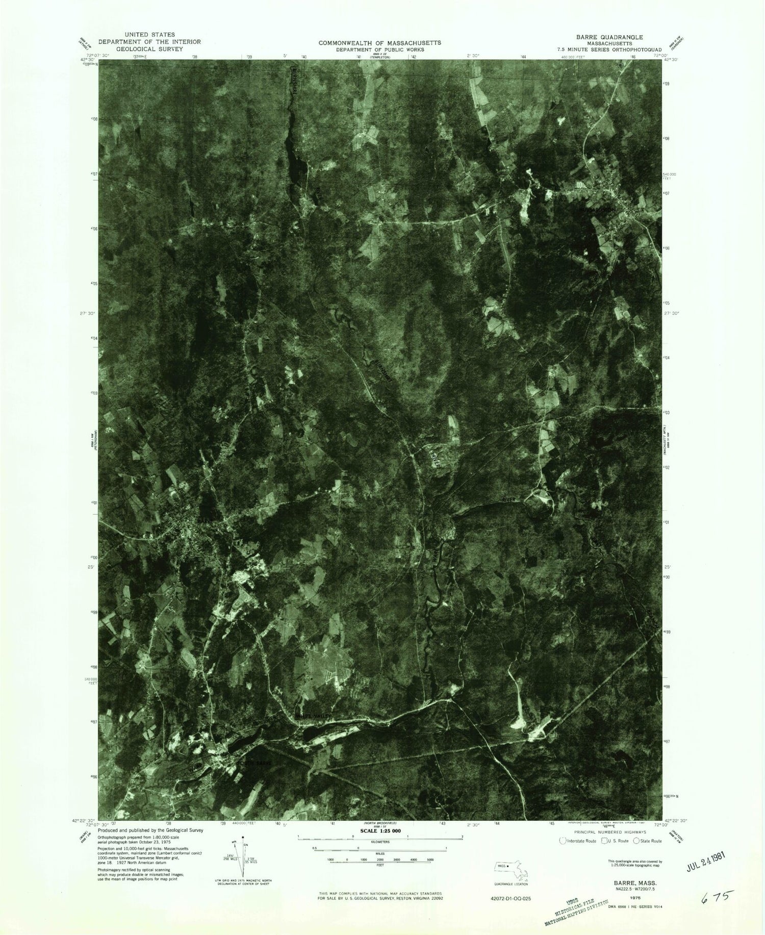
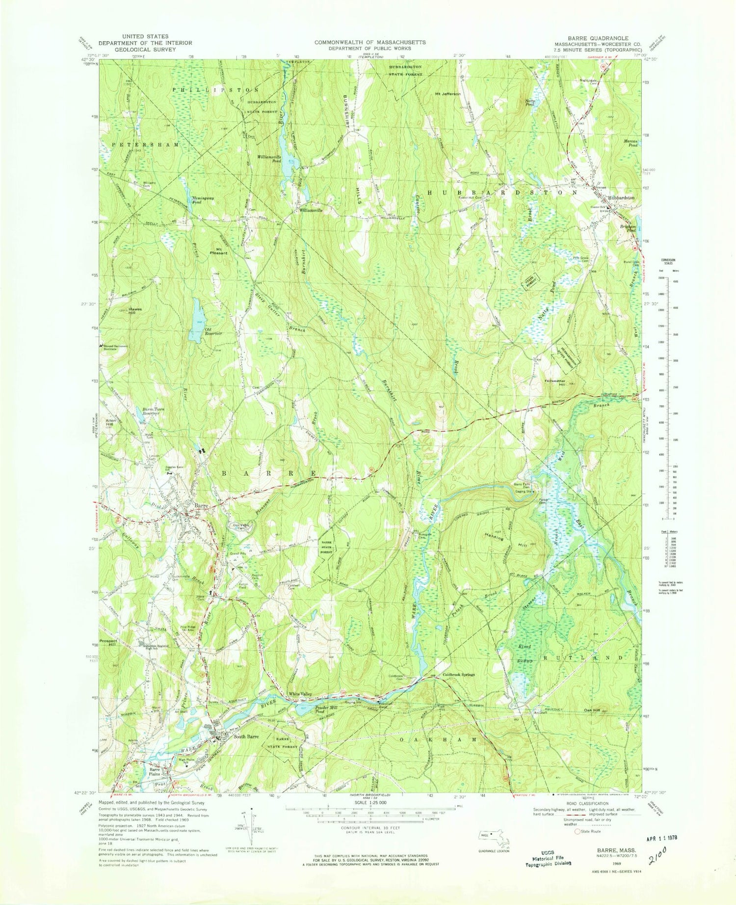
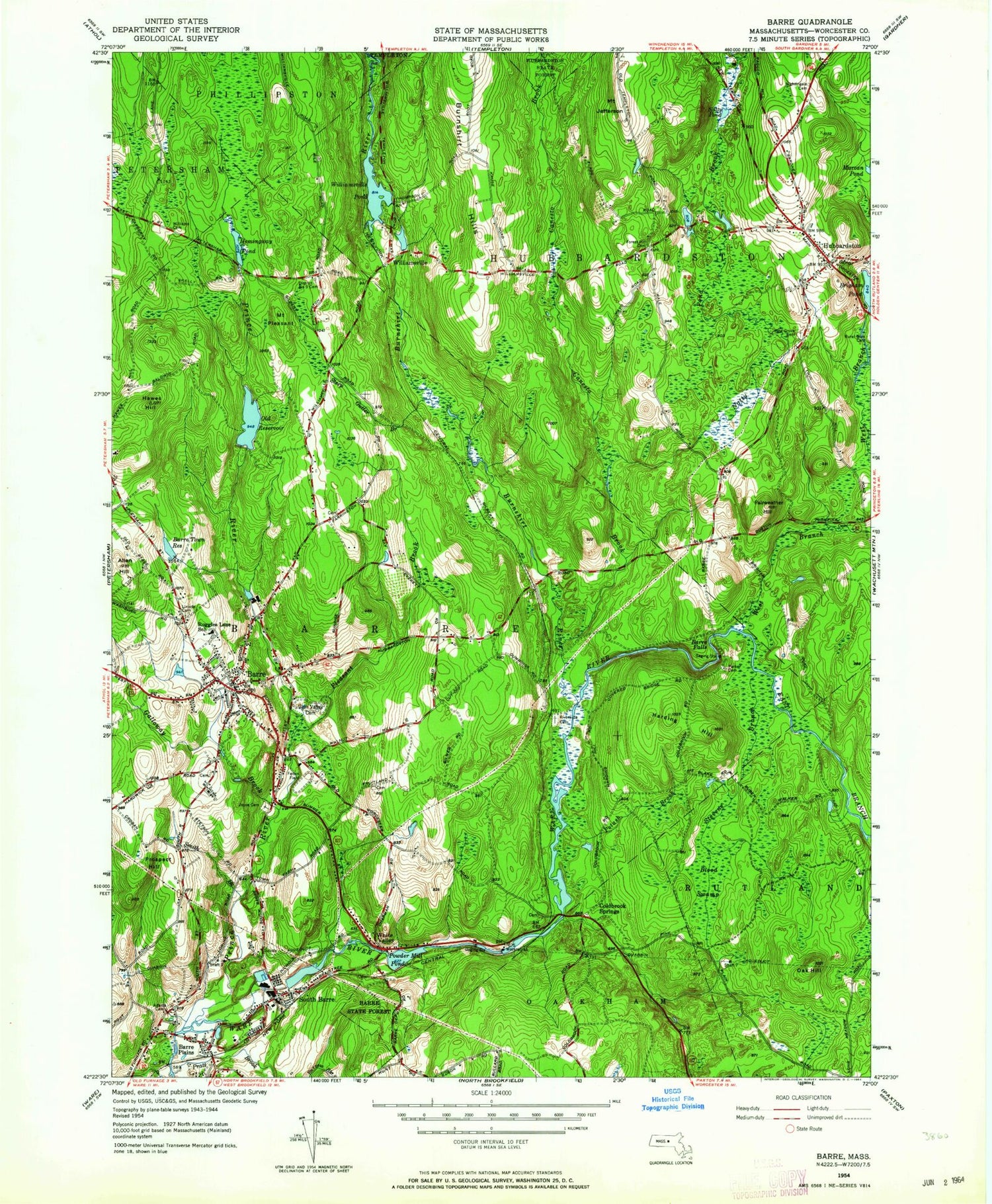
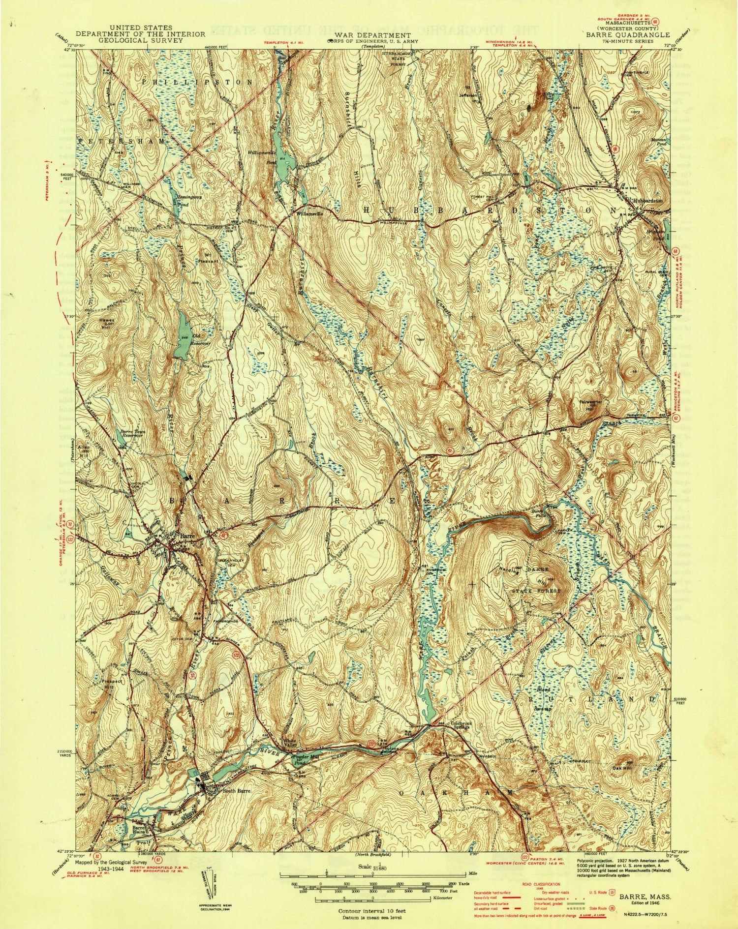
Classic USGS Barre Massachusetts 7.5'x7.5' Topo Map
Couldn't load pickup availability
Historical USGS topographic quad map of Barre in the state of Massachusetts. Typical map scale is 1:24,000, but may vary for certain years, if available. Print size: 24" x 27"
This quadrangle is in the following counties: Worcester.
The map contains contour lines, roads, rivers, towns, and lakes. Printed on high-quality waterproof paper with UV fade-resistant inks, and shipped rolled.
Contains the following named places: Barre Town Reservoir, Quabbin Aqueduct, Parker Cemetery, Felton Field, Williams Cemetery, Riverside Cemetery, Nightingale Cemetery, Saint Joseph's Cemetery, Pine Grove Cemetery, Barre Falls Dam, Coldbrook Cemetery, Lincoln Cemetery, Ruggles Lane School, Quabbin Regional Junior-Senior High School, Glen Valley Cemetery, Blessed Sacrament Novitiate, Buckminster Cemetery, Kendal Plain Cemetery, High Plains School, Caldwell Cemetery, Forest Hill Cemetery, Rural Glen Cemetery, Hubbardston Center Elementary School, Barre State Forest, Holden Dam, Barre Reservoir Dam, Wax Factory Pond Dam, Wax Factory Pond, Williamsville Pond Dam, Parkers Mills (historical), Parkers Brook, Parker Cemetery, Felton Field, Pine Ridge Ski Area, Stetson School, Adams Cemetery, Langley School, Allen Hill, Barre, Barre Falls, Barre Plains, Blood Swamp, Canesto Brook, Coldbrook Springs, East Branch Ware River, Fairweather Hill, Galloway Brook, Harding Hill, Hawes Hill, Hemingway Pond, Hubbardston, Mount Jefferson, Natty Pond, Natty Pond Brook, Oak Hill, Old Reservoir, Pleasant Brook, Mount Pleasant, Potash Brook, Powder Mill Pond, Prince River, Prospect Hill, Smith Brook, South Barre, Steep Gutter Brook, Stevens Branch, West Branch Ware River, White Valley, Williamsville, Williamsville Pond, Dicks Brook, Smithville, Barre Falls, Heald Village, Babbitt Hill, Mill Village, Burnshirt River, Town of Hubbardston, Smithville Post Office (historical), Barre-Bassett Heliport, Town of Barre, Barre Common District, Barre Congregational Church, Barre Post Office, Evangelical Congregational Church, Hubbardston Post Office, Hubbardston Town Hall, Saint Josephs Church, South Barre Post Office, Hubbardston Federated Church, Ruggles Lane School Library, Barre Census Designated Place, Goldsmith's Greenhouse, Stoney Hill Farm, Barre Fire Department Station 2, Hubbardston Fire Department Station 1, Barre Fire Department Station 1 Headquarters, Hubbardston Fire Department Station 2 Headquarters, Barre Ambulance Service, Barre Police Department, Hubbardston Police Department, Barre Town Reservoir, Quabbin Aqueduct, Parker Cemetery, Felton Field, Williams Cemetery, Riverside Cemetery, Nightingale Cemetery, Saint Joseph's Cemetery, Pine Grove Cemetery, Barre Falls Dam, Coldbrook Cemetery, Lincoln Cemetery, Ruggles Lane School, Quabbin Regional Junior-Senior High School, Glen Valley Cemetery, Blessed Sacrament Novitiate, Buckminster Cemetery, Kendal Plain Cemetery, High Plains School, Caldwell Cemetery, Forest Hill Cemetery, Rural Glen Cemetery, Hubbardston Center Elementary School, Barre State Forest, Holden Dam, Barre Reservoir Dam, Wax Factory Pond Dam, Wax Factory Pond, Williamsville Pond Dam, Parkers Mills (historical), Parkers Brook, Parker Cemetery, Felton Field, Pine Ridge Ski Area, Stetson School, Adams Cemetery, Langley School, Allen Hill, Barre, Barre Falls, Barre Plains, Blood Swamp, Canesto Brook, Coldbrook Springs, East Branch Ware River, Fairweather Hill, Galloway Brook, Harding Hill, Hawes Hill, Hemingway Pond, Hubbardston, Mount Jefferson, Natty Pond, Natty Pond Brook, Oak Hill, Old Reservoir, Pleasant Brook, Mount Pleasant, Potash Brook, Powder Mill Pond, Prince River, Prospect Hill, Smith Brook, South Barre, Steep Gutter Brook, Stevens Branch, West Branch Ware River, White Valley, Williamsville, Williamsville Pond, Dicks Brook, Smithville, Barre Falls, Heald Village, Babbitt Hill, Mill Village, Burnshirt River, Town of Hubbardston, Smithville Post Office (historical), Barre-Bassett Heliport, Town of Barre, Barre Common District, Barre Congregational Church, Barre Post Office, Evangelical Congregational Church, Hubbardston Post Office, Hubbardston Town Hall, Saint Josephs Church, South Barre Post Office, Hubbardston Federated Church, Ruggles Lane School Library, Barre Census Designated Place, Goldsmith's Greenhouse, Stoney Hill Farm, Barre Fire Department Station 2, Hubbardston Fire Department Station 1, Barre Fire Department Station 1 Headquarters, Hubbardston Fire Department Station 2 Headquarters, Barre Ambulance Service, Barre Police Department, Hubbardston Police Department, Barre Town Reservoir, Quabbin Aqueduct, Parker Cemetery, Felton Field, Williams Cemetery, Riverside Cemetery, Nightingale Cemetery, Saint Joseph's Cemetery, Pine Grove Cemetery, Barre Falls Dam, Coldbrook Cemetery, Lincoln Cemetery, Ruggles Lane School, Quabbin Regional Junior-Senior High School, Glen Valley Cemetery, Blessed Sacrament Novitiate, Buckminster Cemetery, Kendal Plain Cemetery, High Plains School, Caldwell Cemetery, Forest Hill Cemetery, Rural Glen Cemetery, Hubbardston Center Elementary School, Barre State Forest, Holden Dam, Barre Reservoir Dam, Wax Factory Pond Dam, Wax Factory Pond, Williamsville Pond Dam, Parkers Mills (historical), Parkers Brook, Parker Cemetery, Felton Field, Pine Ridge Ski Area