MyTopo
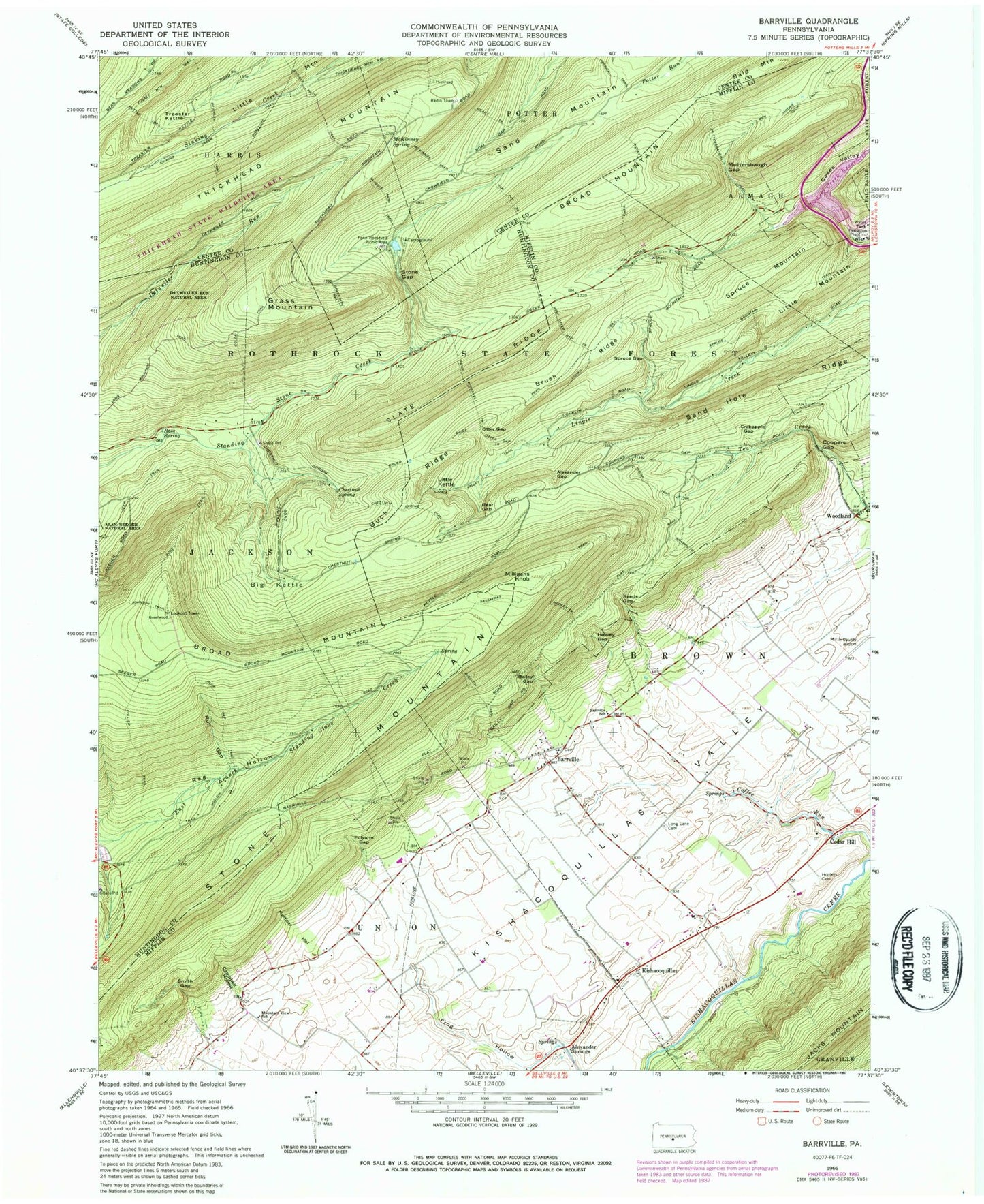
Classic USGS Barrville Pennsylvania 7.5'x7.5' Topo Map
Couldn't load pickup availability
Historical USGS topographic quad map of Barrville in the state of Pennsylvania. Typical map scale is 1:24,000, but may vary for certain years, if available. Print size: 24" x 27"
This quadrangle is in the following counties: Centre, Huntingdon, Mifflin.
The map contains contour lines, roads, rivers, towns, and lakes. Printed on high-quality waterproof paper with UV fade-resistant inks, and shipped rolled.
Contains the following named places: Alexander Gap, Bailey Gap, Barrville, Barrville School, Bear Gap, Bear Trail, Ben Jacobs Trail, Big Kettle, Bigelow Trail, Broad Mountain, Brush Ridge, Brush Ridge Trail, Buck Ridge, Campbell Hollow, Cedar Hill, Chestnut Spring, Chestnut Spring Trail, Collier Trail, Colon Trail, Coopers Gap, Coxes Valley, Crabapple Gap, Detweiler Run Natural Area, Frog Hollow, Grass Mountain, Grass Mountain Trail, Hartzler Hollow, Hooley Gap, Hooley Trail, Hooleys Cemetery, Indian Trail, Jacks Mountain, Johnson Trail, Kettle Trail, Kishacoquillas, Laurel Creek Reservoir, Lingle Valley Trail, Little Kettle, Little Mountain, Long Lane Cemetery, McKinney Spring, Milligans Knob, Muttersbaugh Gap, Muttersbaugh Trail, New Otter Gap Trail, Otter Gap, Otter Gap Trail, Penn Roosevelt State Park, Polyann Gap, Rag Hollow, Reeds Gap, Reichley Trail, Ross Spring, Ross Trail, Ruff Gap, Ruff Gap Trail, Sand Hole Ridge, Sassafras Trail, Sharps Trail, Shingle Path Trail, Sinking Creek Trail, Slate Ridge, Smith Gap, Spruce Gap, Spruce Mountain, Spruce Mountain Trail, Stone Gap, Treaster Kettle, Thickhead Mountain, Broad Mountain, Hessick Trail, Long Mountain Trail, Mountain View School, Shingle Path Trail, Tar Pit Trail, Plum Airport (historical), Mifflin County Airport, Laurel Creek Dam, Mitchell School (historical), Greenwood Tower, Gap School, McKinney Trail, Coffee Run Spring, Yoder Spring, Thickhead State Wildlife Area, Alexander Springs, Rocks at Laurel Creek Reservoir, Greenwood Furnace, Township of Brown, Barrville Census Designated Place, Barrville Mennonite Cemetery, Yoder Zook Cemetery, Alexander Gap, Bailey Gap, Barrville, Barrville School, Bear Gap, Bear Trail, Ben Jacobs Trail, Big Kettle, Bigelow Trail, Broad Mountain, Brush Ridge, Brush Ridge Trail, Buck Ridge, Campbell Hollow, Cedar Hill, Chestnut Spring, Chestnut Spring Trail, Collier Trail, Colon Trail, Coopers Gap, Coxes Valley, Crabapple Gap, Detweiler Run Natural Area, Frog Hollow, Grass Mountain, Grass Mountain Trail, Hartzler Hollow, Hooley Gap, Hooley Trail, Hooleys Cemetery, Indian Trail, Jacks Mountain, Johnson Trail, Kettle Trail, Kishacoquillas, Laurel Creek Reservoir, Lingle Valley Trail, Little Kettle, Little Mountain, Long Lane Cemetery, McKinney Spring, Milligans Knob, Muttersbaugh Gap, Muttersbaugh Trail, New Otter Gap Trail, Otter Gap, Otter Gap Trail, Penn Roosevelt State Park, Polyann Gap, Rag Hollow, Reeds Gap, Reichley Trail, Ross Spring, Ross Trail, Ruff Gap, Ruff Gap Trail, Sand Hole Ridge, Sassafras Trail, Sharps Trail, Shingle Path Trail, Sinking Creek Trail, Slate Ridge, Smith Gap, Spruce Gap, Spruce Mountain, Spruce Mountain Trail, Stone Gap, Treaster Kettle, Thickhead Mountain, Broad Mountain, Hessick Trail, Long Mountain Trail, Mountain View School, Shingle Path Trail, Tar Pit Trail, Plum Airport (historical), Mifflin County Airport, Laurel Creek Dam, Mitchell School (historical), Greenwood Tower, Gap School, McKinney Trail, Coffee Run Spring, Yoder Spring, Thickhead State Wildlife Area, Alexander Springs, Rocks at Laurel Creek Reservoir, Greenwood Furnace, Township of Brown, Barrville Census Designated Place, Barrville Mennonite Cemetery, Yoder Zook Cemetery