MyTopo
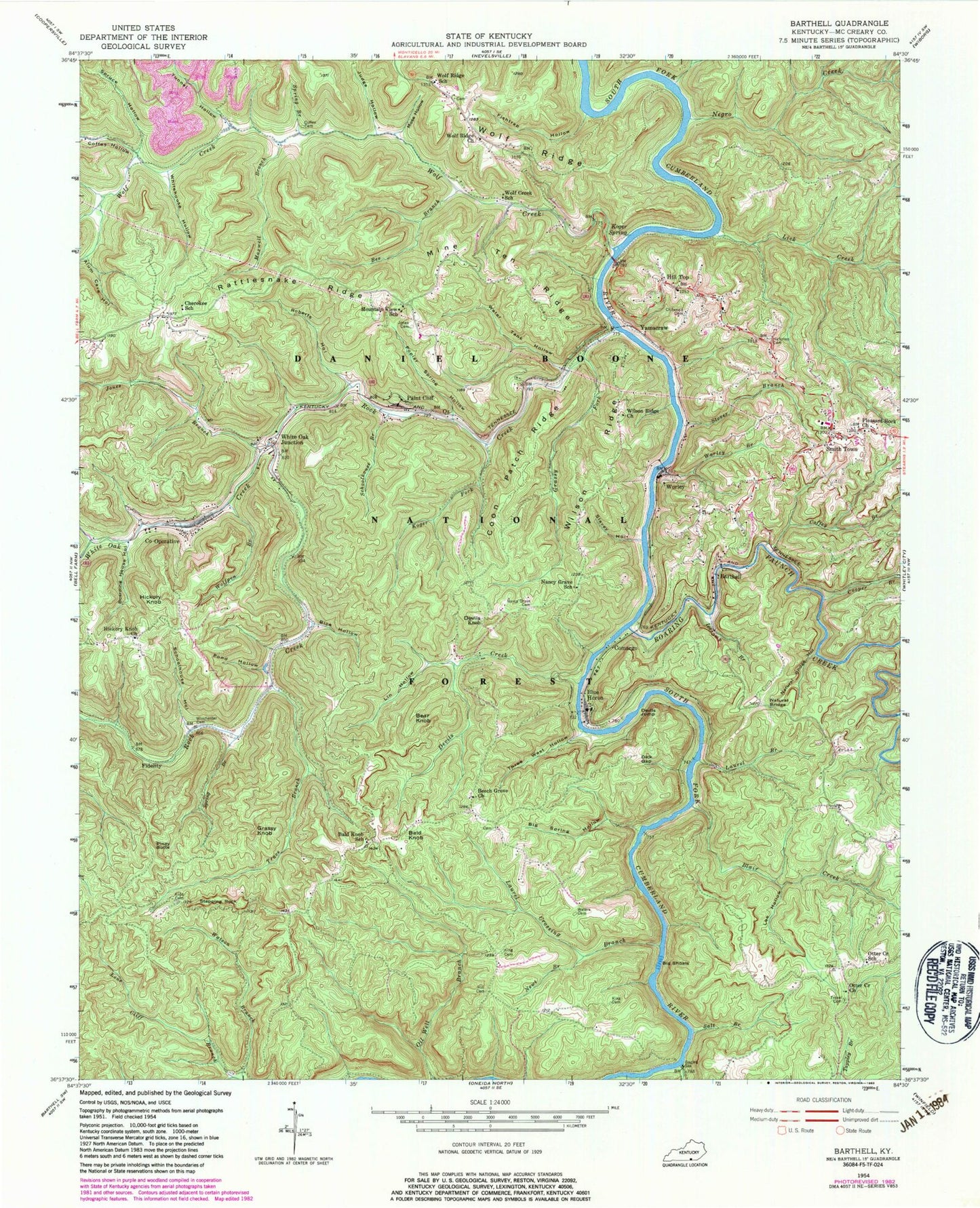
Classic USGS Barthell Kentucky 7.5'x7.5' Topo Map
Couldn't load pickup availability
Historical USGS topographic quad map of Barthell in the state of Kentucky. Typical map scale is 1:24,000, but may vary for certain years, if available. Print size: 24" x 27"
This quadrangle is in the following counties: McCreary.
The map contains contour lines, roads, rivers, towns, and lakes. Printed on high-quality waterproof paper with UV fade-resistant inks, and shipped rolled.
Contains the following named places: Moss Hollow, Alum Cave Hollow, Bald Knob, Barthell, Bear Creek, Bear Knob, Bee Branch, Beech Grove Church, Bice Hollow, Big Shoals, Big Spring Hollow, Blair Creek, Blue Heron, Boarding House Hollow, Cabin Branch, Cheroke School, Chitwood Cemetery, Co-Operative, Coffey Branch, Coffey Cemetery, Coffey Hollow, Comargo, Coon Patch Ridge, Cooper Branch, Cotton Patch Hollow, Devils Creek, Devils Jump, Devils Knob, Dick Gap, Fidelity, Fishtrap Hollow, Grassy Fork, Grassy Knob, Hickman Cemetery, Hickory Knob, Hickory Knob Church, Hill Cemetery, Hill Top, Icecamp Branch, Jones Branch, Jones Cemetery, Judge Hollow, Kidd Cemetery, King Cemetery, King Cemetery, Koger Fork, Koger Spring, Laurel Branch, Laurel Crossing Branch, Lee Hollow, Lick Creek, Lin Hollow, Maxwell Branch, Mine Ten Ridge, Nancy Grave Cemetery, Nancy Grave School, Natural Bridge, Natural Bridge Hollow, Negro Creek, Newt Branch, Otter Creek Church, Otter Creek School, Oz, Paint Cliff, Piney Butte, Pleasant Rock Church, Pond Hollow, Poplar Spring Hollow, Roaring Paunch Creek, Roberts Hollow, Roberts Hollow, Rock Creek, Salt Branch, Schoolhouse Branch, Schoolhouse Hollow, Slavey Hollow, Spring Branch, Spring Branch, Spruce Hollow, Stepping Rock, Stover Branch, Three West Hollow, Trace Branch, Troxel Cemetery, Tunnel Hollow, Water Tank Hollow, Waters Cemetery, White Oak Creek, White Oak Junction, Whitehouse Hollow, Wilson Ridge, Wilson Ridge Church, Winchester Cemetery, Wolf Creek, Wolf Creek School, Wolf Ridge Church, Wolf Ridge School, Wolfpen Branch, Worley, Worley Branch, Yamacraw, Smith Town, Bald Knob School, Mountain View School, Yamacraw Post Office (historical), Hill Top Post Office (historical), Big South Fork (historical), Big South Fork Post Office (historical), Blue Heron Campground, Lonesome, Comargo Post Office (historical), Devils Jump Rapids, Bear Creek Overlook, Wolfe Ridge Fire Station, Rattlesnake Ridge Fire Station