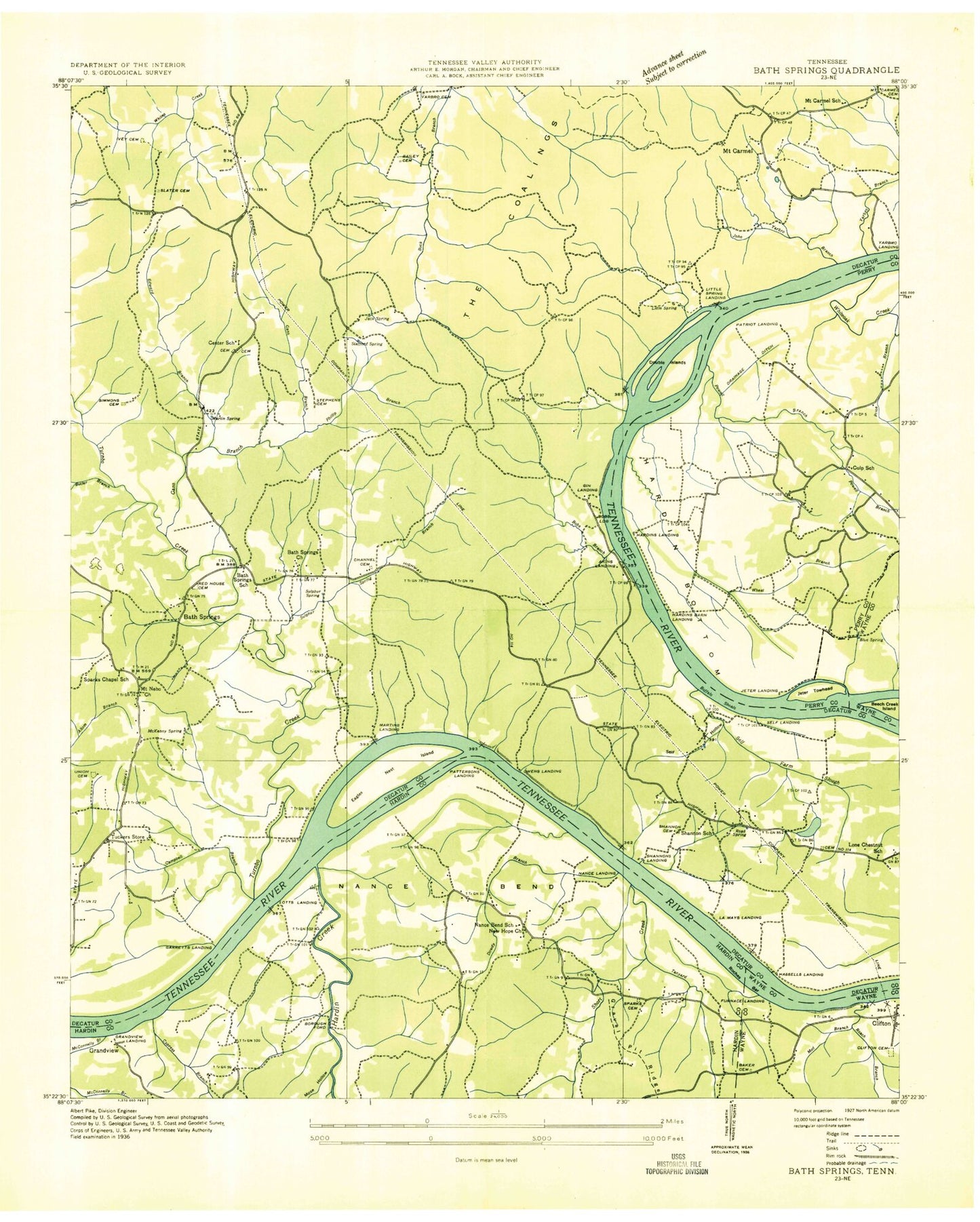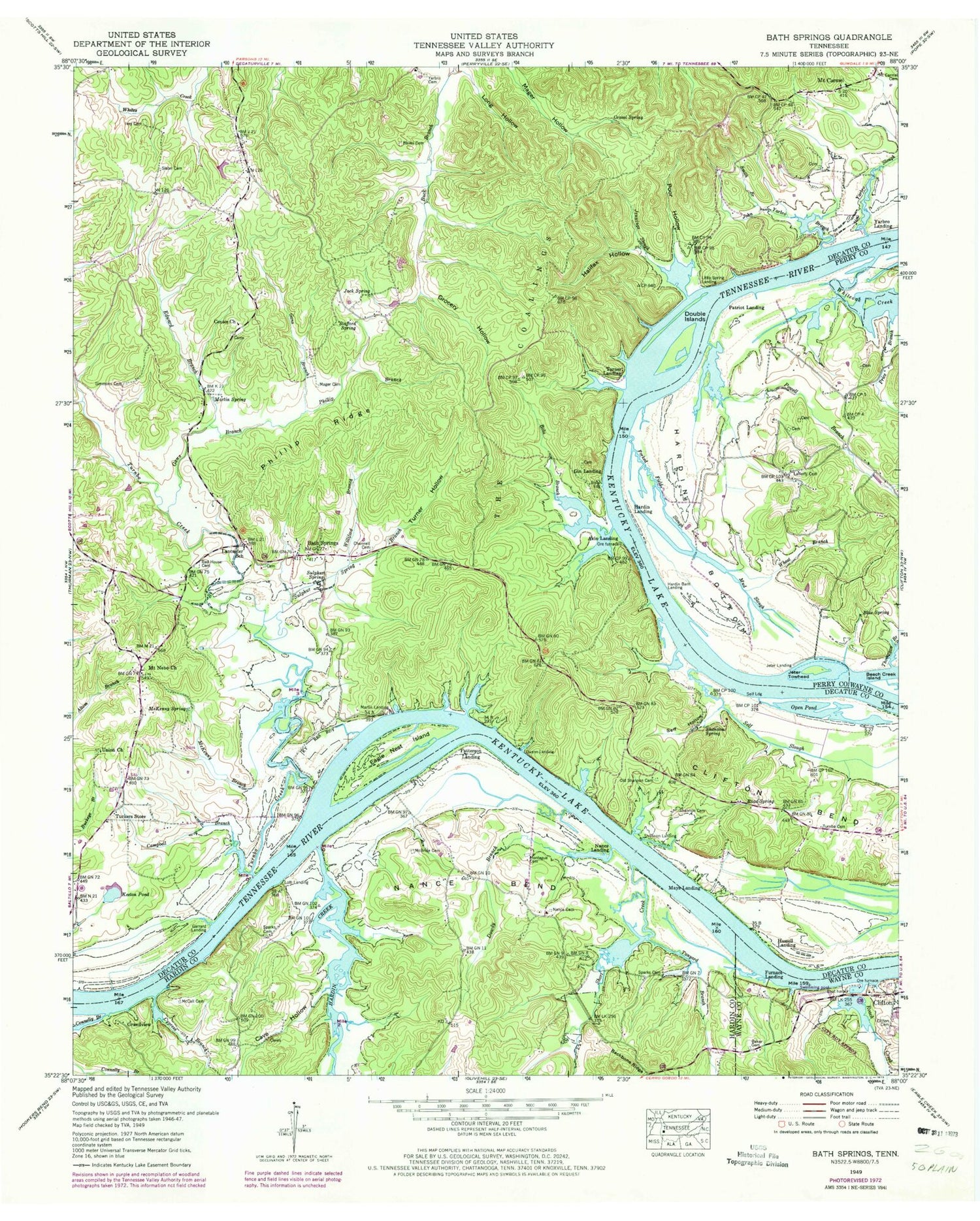
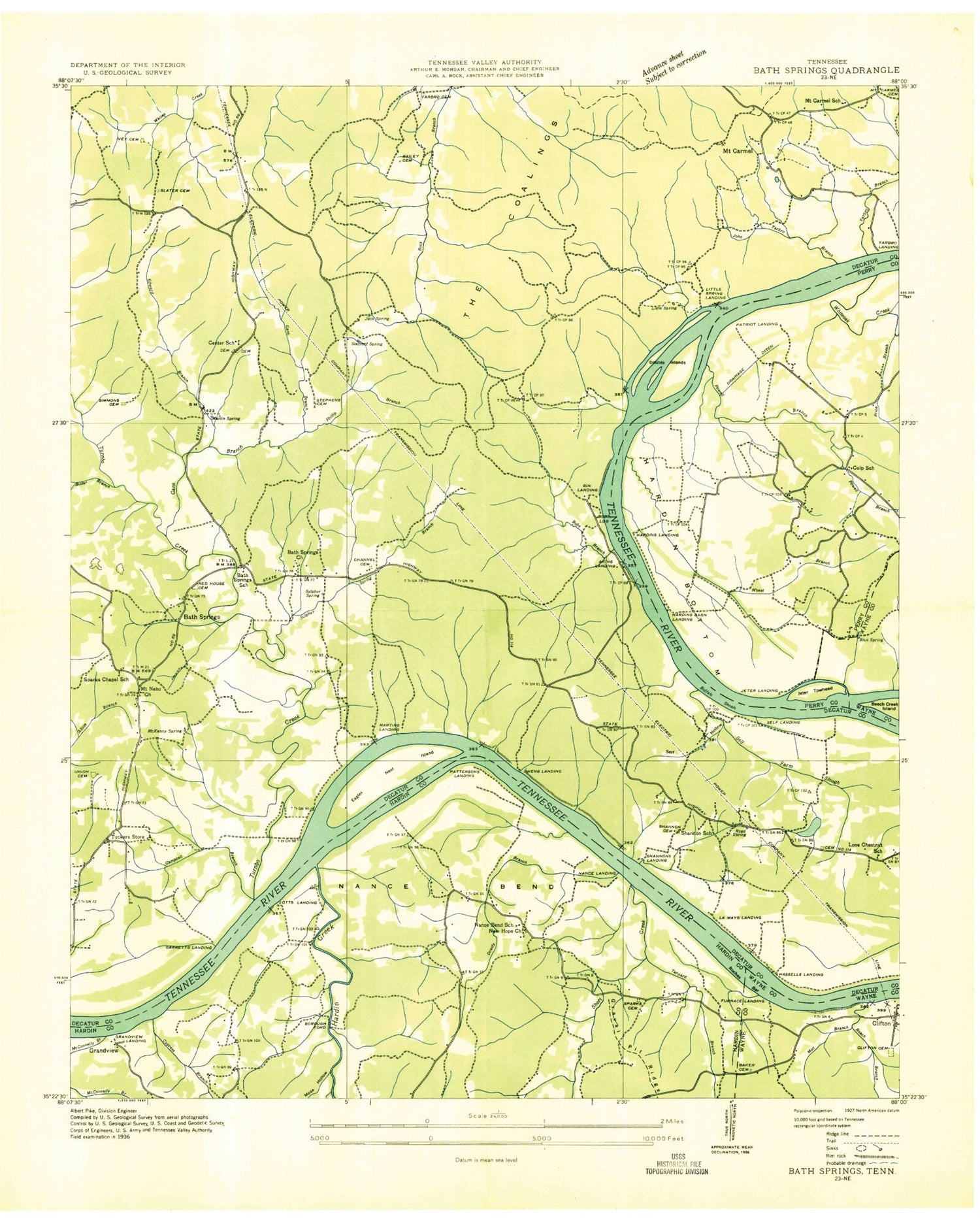
MyTopo
Classic USGS Bath Springs Tennessee 7.5'x7.5' Topo Map
Couldn't load pickup availability
Historical USGS topographic quad map of Bath Springs in the state of Tennessee. Map scale may vary for some years, but is generally around 1:24,000. Print size is approximately 24" x 27"
This quadrangle is in the following counties: Decatur, Hardin, Perry, Wayne.
The map contains contour lines, roads, rivers, towns, and lakes. Printed on high-quality waterproof paper with UV fade-resistant inks, and shipped rolled.
Contains the following named places: Akin Landing, Altom Branch, Backbone Ridge Cemetery, Bailey Cemetery, Baker Cemetery, Bath Springs, Bath Springs Baptist Church, Blue Spring, Bobs Branch, Bobs Landing, Borough Ford, Buckeys Landing, Buffalo Shoals, Butler Branch, Campbell Branch, Cave Hollow, Center Camp Ground, Center Church, Center School, Channell Cemetery, Clifton Bend, Clifton Cemetery, Clifton Marina, Commissioner District 1, Connelly Branch, Culp Cemetery, Culp School, Cypress Branch, Decatur County Volunteer Fire Department Station 6 Bobs Landing, Decatur Furnace, Double Islands, Dowdy Branch, Eagle Nest Island, Edward Branch, Forked Field Slough, Furnace Landing, Gans Branch, Garrard Landing, Gin Landing, Grandview, Grandview Landing, Gravel Spring, Grocery Hollow, Halifax Hollow, Hardin Barn Landing, Hardin Bottom, Hardin Creek, Hardin Landing, Hassell Landing, Hughes Hollow, Ivey Cemetery, Jack Spring, James Ferry, Jennings Slough, Jeter Landing, Jeter Towhead, Jim Yarbro Slough, John Yarbro Branch, Keeton Pond, Kentucky Lake, Ketton Cemetery, Lafferty Cemetery, Lancaster School, Little Spring, Little Spring Landing, Lone Chestnut Baptist Church, Lone Chestnut School, Lott Landing, Lott Landing Cemetery, Mager Cemetery, Martin Landing, Martin Spring, Mays Landing, McBride Cemetery, McCall Cemetery, McKenny Branch, McKenny Spring, Montague Cemetery, Mount Carmel, Mount Carmel School, Mount Nebo Church, Mount Nebo School, Mud Slough, Nance Bend, Nance Cemetery, Nance Landing, Nances School, Old Shannon Cemetery, Open Pond, Owens Landing, Patriot Landing, Patterson Landing, Phillip Branch, Phillip Ridge, Poor Hollow, Powell Branch, Price Branch, Red House Cemetery, Roach Creek, Road Spring, Roches Bar, Self Hollow, Self Landing, Self Slough, Shannon Cemetery, Shannon Landing, Shannon School, Shannon Spring, Short Creek, Simmons Cemetery, Slater Cemetery, Smith Branch, Sparks Cemetery, Sparks Chapel School, Stafford Spring, Sulphur Branch, Sulphur Spring, Tanyard Branch, Thompson Branch, Tuckers Store, Turnbo Cemetery, Turnbo Creek, Turner Hollow, Turner Landing, Union Cemetery, Union Church, Wheat Branch, Wheat Store, Whiteoak Creek, Williford Branch, Yarbro Cemetery, Yarbro Landing, ZIP Code: 38311