MyTopo
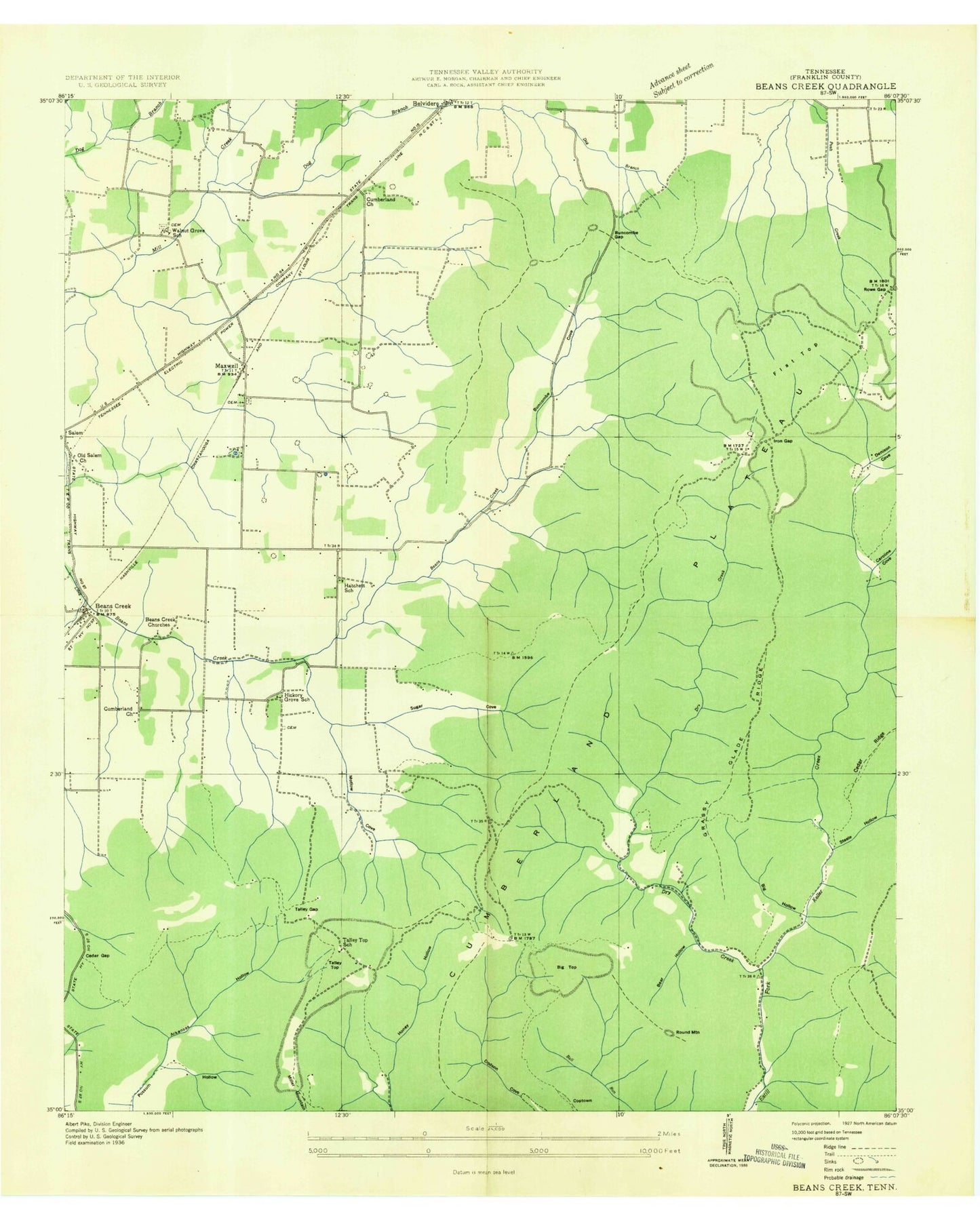
Classic USGS Beans Creek Tennessee 7.5'x7.5' Topo Map
Couldn't load pickup availability
Historical USGS topographic quad map of Beans Creek in the state of Tennessee. Map scale is 1:24000. Print size is approximately 24" x 27"
This quadrangle is in the following counties: Franklin.
The map contains contour lines, roads, rivers, towns, and lakes. Printed on high-quality waterproof paper with UV fade-resistant inks, and shipped rolled.
Contains the following named places: Anderson Bluff, Anderson Bluff, Arkansas Hollow, Arkansas Hollow, Arledge Cemetery, Arledge Cemetery, Baker Branch, Baker Branch, Baker Cemetery, Baker Cemetery, Beans Creek, Beans Creek, Beans Creek Church (historical), Beans Creek Church (historical), Bear Hollow, Bear Hollow, Belvidere Church, Belvidere Church, Big Hollow, Big Hollow, Big Top, Big Top, Bishop Top, Bishop Top, Blooin Hollow, Blooin Hollow, Bradford Mountain, Bradford Mountain, Bridges Cemetery, Bridges Cemetery, Buncombe Cove, Buncombe Cove, Buncombe Gap, Buncombe Gap, Buncombe Ridge, Buncombe Ridge, Callaway Cemetery, Callaway Cemetery, Caroline Cove, Caroline Cove, Cedar Gap, Cedar Gap, Cedar Ridge, Cedar Ridge, Clark School (historical), Clark School (historical), Coptown, Coptown, Cumberland Church, Cumberland Church, Cynthia Hollow, Cynthia Hollow, Dog Branch, Dog Branch, Dripping Spring, Dripping Spring, Dry Creek, Dry Creek, Flat Top, Flat Top, Grassy Glade, Grassy Glade, Grassy Glade Ridge, Grassy Glade Ridge, Gugelman Hollow, Gugelman Hollow, Hatchett Cemetery, Hatchett Cemetery, Hatchett School (historical), Hatchett School (historical), Hickory Grove, Hickory Grove, Hickory Grove School (historical), Hickory Grove School (historical), Hickory Mill Spring, Hickory Mill Spring, Hill Cemetery, Hill Cemetery, Horton Hollow, Horton Hollow, Huntland Division (historical), Huntland Division (historical), Iron Gap, Iron Gap, Jones Cemetery, Jones Cemetery, Keith Cemetery, Keith Cemetery, Keller Creek, Keller Creek, Lipscomb Cemetery, Lipscomb Cemetery, Low Gap, Low Gap, Mason Cemetery, Mason Cemetery, Mathias Branch, Mathias Branch, Maxwell, Maxwell, Maxwell Baptist Church, Maxwell Baptist Church, Maxwell Community Cemetery, Maxwell Community Cemetery, Maxwell School (historical), Maxwell School (historical), Motlow Cemetery, Motlow Cemetery, Motlow Cove, Motlow Cove, Motlow Hollow, Motlow Hollow, Needmore Cemetery, Needmore Cemetery, Noah Cemetery, Noah Cemetery, Old Salem Church, Old Salem Church, Old stovall Cemetery, Old stovall Cemetery, Pogue Hollow, Pogue Hollow, Polecat Hollow, Polecat Hollow, Polly Crockett Cemetery, Polly Crockett Cemetery, Pratt Cemetery, Pratt Cemetery, Punch Bowl, Punch Bowl, Ransom Hollow, Ransom Hollow, Rattlesnake Spring, Rattlesnake Spring, Reese Deadening Hollow, Reese Deadening Hollow, Reynolds Cemetery, Reynolds Cemetery, Roberson Cove, Roberson Cove, Rock Spring, Rock Spring, Rock Spring Ridge, Rock Spring Ridge, Round Mountain, Round Mountain, Rowe Gap, Rowe Gap, Smith Cemetery, Smith Cemetery, Spout Spring, Spout Spring, Steele Hollow, Steele Hollow, Talley Top, Talley Top, Talley Top School (historical), Talley Top School (historical), Trigg Cemetery, Trigg Cemetery, Vanzandt Cemetery, Vanzandt Cemetery, Walnut Grove, Walnut Grove, Walnut Grove Cemetery, Walnut Grove Cemetery, Walnut Grove School (historical), Walnut Grove School (historical), Walnut Grove United Methodist Church, Walnut Grove United Methodist Church, Wash Hole Hollow, Wash Hole Hollow, Watson Cemetery, Watson Cemetery, Wilhie Creek, Wilhie Creek, Williams Cemetery, Williams Cemetery