
MyTopo
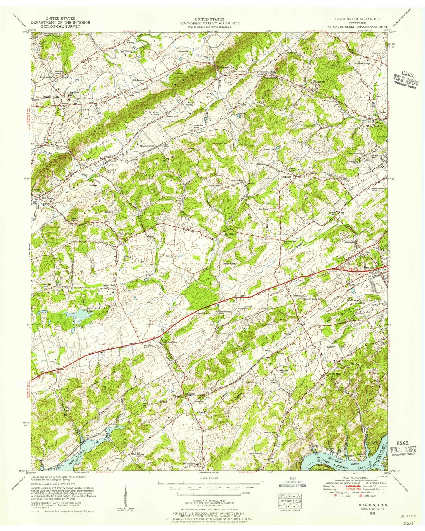
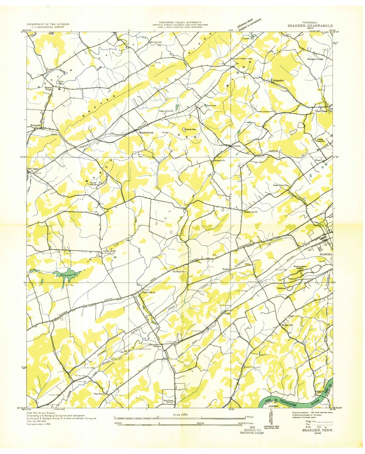
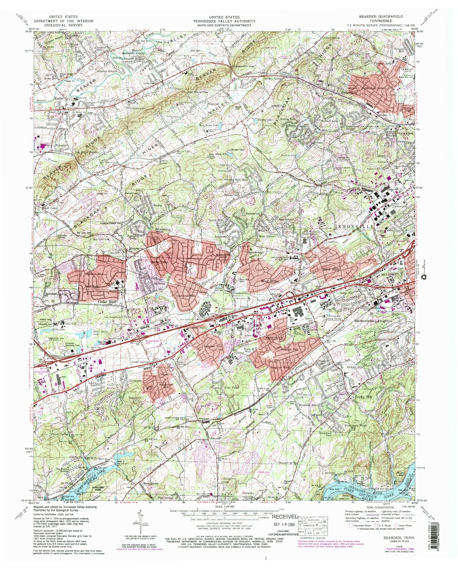
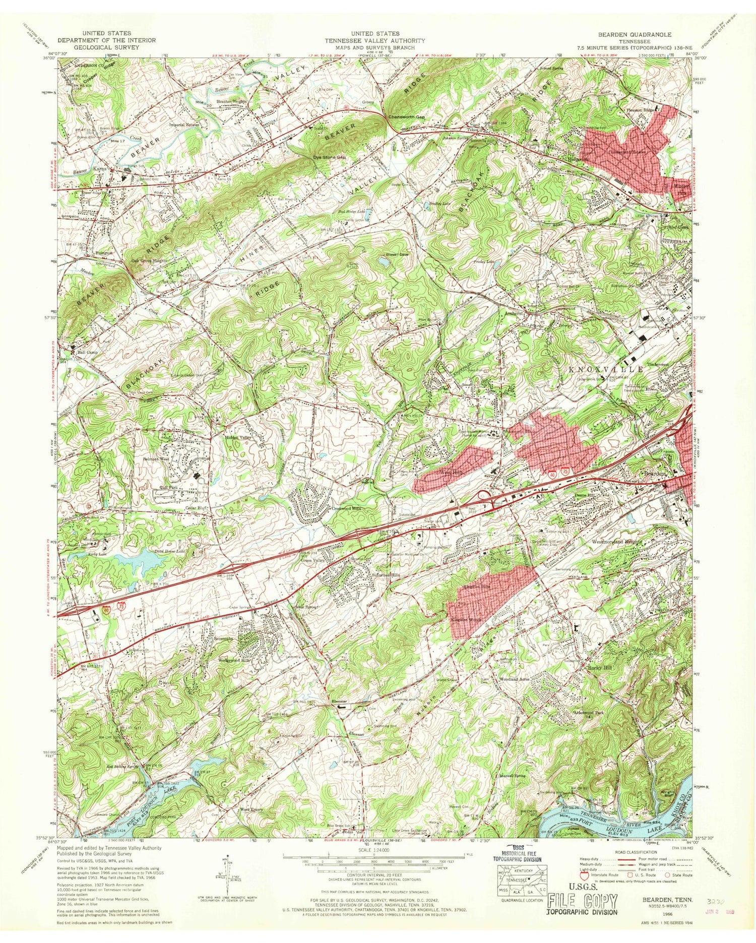
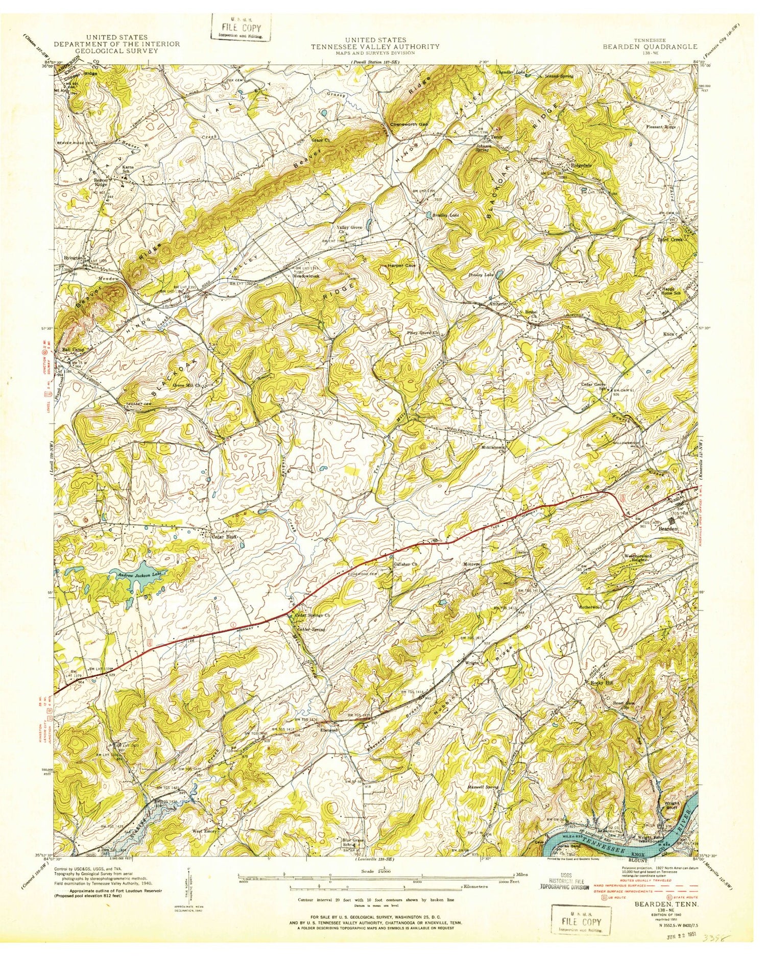
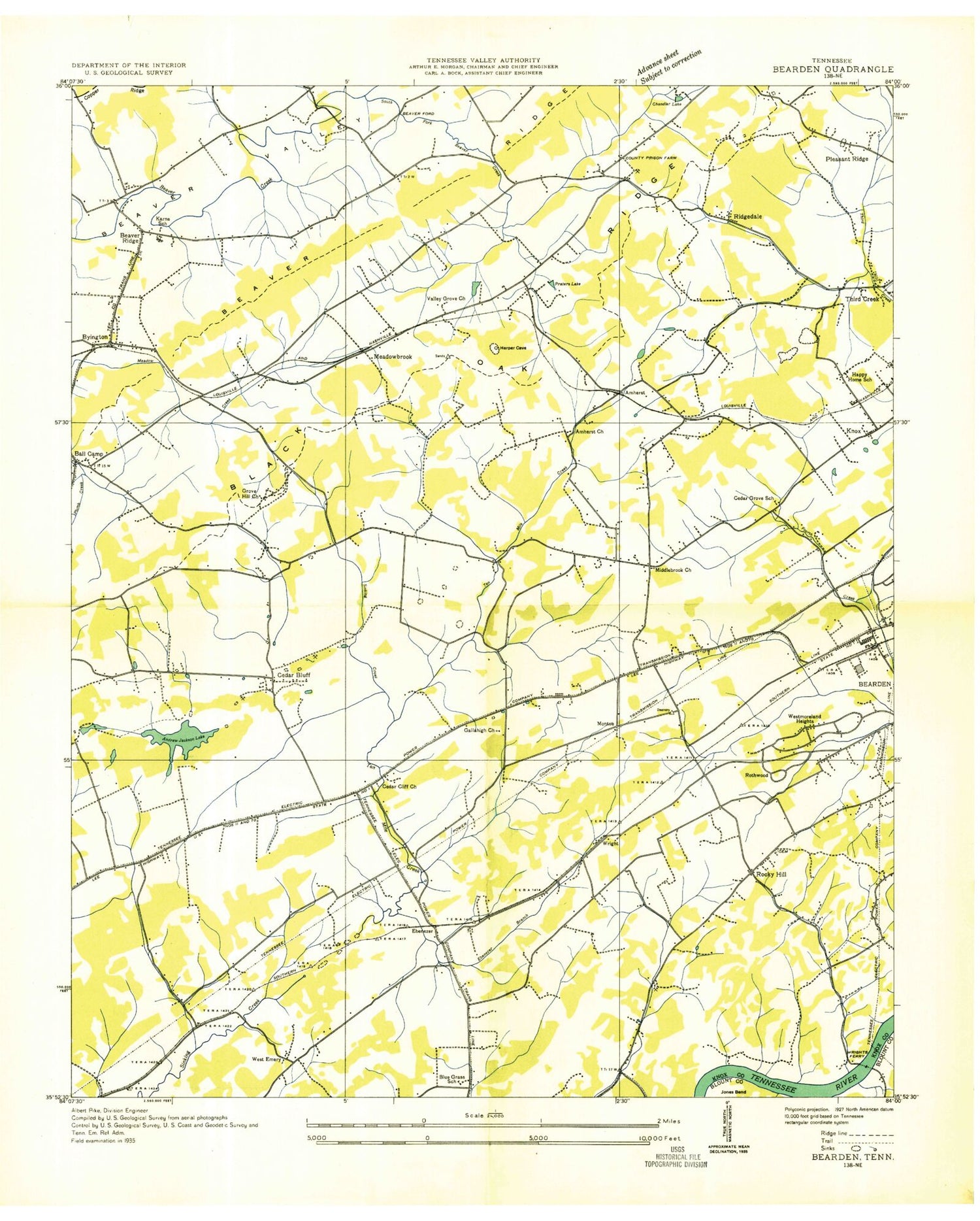
Classic USGS Bearden Tennessee 7.5'x7.5' Topo Map
Couldn't load pickup availability
Historical USGS topographic quad map of Bearden in the state of Tennessee. Typical map scale is 1:24,000, but may vary for certain years, if available. Print size: 24" x 27"
This quadrangle is in the following counties: Anderson, Blount, Knox.
The map contains contour lines, roads, rivers, towns, and lakes. Printed on high-quality waterproof paper with UV fade-resistant inks, and shipped rolled.
Contains the following named places: Blackoak Ridge, Spanish Trails, Statesview, Stonebrook, Suburban Hills, Tan Rara oesta, Tates School, Ten Mile Creek, Third Creek, Trails West, Valley Grove Church, Walker Springs, Webb School, Wedgewood Hills, West Forest, West Hills, West Side YMCA, West Town Mall, Westavia Woods, Westborough, Westlyn, Westmoreland Heights, Windsor Park, Wooded Acres, Woodland Acres, Wright Bluff, Wrights Ferry Church, Zion Childrens Home, Aldenwood Park, Amherst, Appalachian Child Development Center, Arnstein Community Center, Ashley Oaks, Badgett Hollow, Ball Camp, Ball Road Church, Bearden Cemetery, Bearden High School, Bearden Junior High School, Methodist Cemetery, Beeler Cemetery, Belmont West, Berkshire Wood, Bird Cemetery, Bonneville Estates, Brentwood, Brimer Cemetery, Bud Hodge Lake, Byington, Camelot, Campground Chapel, Canby Hills, Cedar Bluff, Cedar Bluff, Cedar Bluff Church, Cedar Bluff Schools, Cedar Springs, Cheneworth Gap, Childs Cemetery, Crestwood Hills, Cumberland Estates, Dead Horse Lake Golf Course, Deane Hill, Duncan Spring, Dunn Cemetery, Dye Stone Gap, Ebenezer Branch, Ebenezer Church, Echo Valley, Edgewood Cemetery, Eldridge Spring, Eubanks Chapel Cemetery, Everhard Mission Church, Fair Oaks, Faith Church, Fox Fire, Fox Road Dock, Fox Spring, Galewood, Good Samaritan Church, Grace Church, Green Valley, Greenwood Heights, Grove Hill Church, Gulf Park, Gulfwood, Happy Home Cemetery, Heather Heights, Hickory Hills, Hidden Hills, Hidden Valley, Holloway Cemetery, Hospital School, Hunting Hills West, Imperial Estates, Johnson Spring, Jones Cemetery, Karns, Karns Church, King Arthur Court, Kingston Hills, Kingston Woods, Kirby Lake, Knoxville Boat Club Dock, Knoxville Memorial Park, Lakeview Church, Landmark, Lillian A Pedigo School, Mars Hill Cemetery, Mars Hill Church, Lake Mary Ella, Maxwell Cemetery, Maxwell Spring, Middlebrook Acres, Middlebrook Pike United Methodist Church, Middlebrook Pike Church, Montwood Church, New Covenant Church, Northshore Church, Northshore Woods, Northwest General Hospital (historical), Nubbin Ridge, Oak Grove Heights, Oehler Springs, Oxmore Hills, Parkwest Medical Center, Phibbs Cemetery, Pine Springs, Piney Grove Church, Pleasant Hills, Pleasant Ridge, Red Hollow, Reed Cemetery, Reed Cemetery, Rennbore, Ridgedale, Roberts Spring, Rocky Hill, Sacred Heart Church and School, Saint Marks United Methodist Church, Schaad Spring, Sevenoaks, Shannondale Homes, Little Creek Airpark (historical), Tan Rara Airport (historical), Jimmy Baisley Lake, Jimmy Baisley Lake Dam, Tekoa, Tekoa Church, Timbercrest, Van Loon Cemetery, Walridge Church, West End Church, West Hills Church, West Knoxville Church, West Towne Church, Wright Cemetery, Bearden, Beaver Ridge, Beaver Ridge United Methodist Church, Bethel United Methodist Church, Bethlehem Star Church, Bradley Lake, Calvary Church, Cokesbury United Methodist Church, Cox View Cemetery, Dead Horse Lake, Deane Hill Golf and Country Club, Beaver Ford, Chandler Lake (historical), Countryside, Edington (historical), Farrington, Glen Arden, Golden Meadows, Holiday Hills, Kensington, Kinkaid (historical), Meadowbrook, Montvue, Rothwood, Ten Mile, Trails End, Wrights Ferry (historical), Gradys Chapel Methodist Church, West Emory, Ebenezer, Amherst School, Ball Camp Baptist Church, Ball Camp Elementary School, Ball Camp Park, Bearden Shopping Centery, Byington Church, Cedar Bluff Intermediate School, Cedar Bluff Middle School, Cedar Bluff Primary School, Cedar Bluff Quarry, Cedar Bluff Shopping Center, Cedar Cliff Church, Cedar Grove School (historical), Cedar Springs Church, Cedar Springs Shopping Center, Central Baptist Church of Bearden, Churhc of the Savior, Cumberland Estates Shopping Center, Karns Fire Department Station 1, Karns Volunteer Fire Department Station 4, Rural - Metro Fire Department Station15, Rural - Metro Fire Department Station 17, Knoxville Fire Department John J Duncan Station 21, First Church of the Nazarene, Gallaher Memorial Baptist Church, Happy Home School (historical), Karns Community Park, Karns High School, Karns Intermediate School, Karns Middle School, Karns Primary School, Knox County Prison Farm (historical), Middlebrook Industrial Park, Montvue Shopping Center, Pleasant Ridge Elementary School, Ridgedale Community Park, Ridgedale Elementary School, Rocky Hill Baptist Church, Rocky Hill Elementary School, Rocky Hill Park, Rocky Hill Shopping Center, Suburban Shopping Center, Sullivan Road Christian Church, Third Creek Baptist Church, Walker Springs Plaza Shopping Center, West Emory Church, West End Academy, West Hills Elementary School, West Hills Park