MyTopo
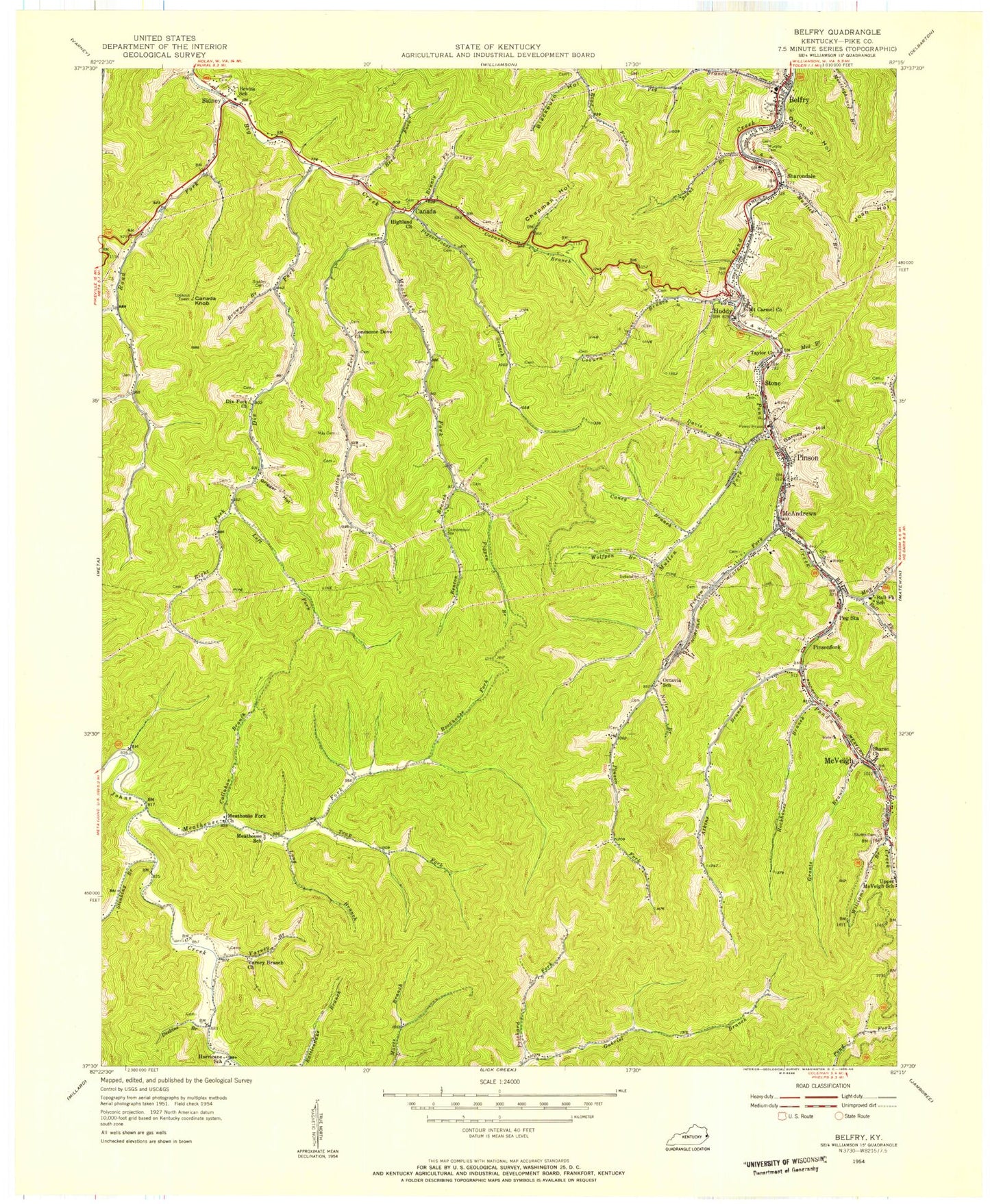
Classic USGS Belfry Kentucky 7.5'x7.5' Topo Map
Couldn't load pickup availability
Historical USGS topographic quad map of Belfry in the state of Kentucky. Map scale may vary for some years, but is generally around 1:24,000. Print size is approximately 24" x 27"
This quadrangle is in the following counties: Pike.
The map contains contour lines, roads, rivers, towns, and lakes. Printed on high-quality waterproof paper with UV fade-resistant inks, and shipped rolled.
Contains the following named places: Akers Rocks, Appalachian First Response Emergency Services, Atkins Branch, Ball Fork, Ball Fork School, Ball Hollow, Barn Hollow, Barney Hollow, Belfry, Belfry Census Designated Place, Belfry Elementary School, Belfry High School, Belfry Post Office, Belfry Railroad Station, Belfry Volunteer Fire Department, Benton Branch, Bevins School, Big Creek Volunteer Fire Department, Blackburn Hollow, Brandy Hollow, Brown Fork, Brunty Fork, Callahan Branch, Canada, Canada Knob, Canada Knob Lookout Tower, Canada Post Office, Caney Branch, Chapman Hollow, Coburn Branch, Coburn Forks School, Coburn School, Crigger Post Office, Davis Branch, Deskins Branch, Deskins Family Cemetery, Deskins Post Office, Dicks Fork School, Dix Fork, Dix Fork Church, Grants Branch, Grigger Hollow, Groundhog Hollow, Hewitt Post Office, Highland Church, Homemade Hollow, Huddy, Huddy Census Designated Place, Huddy Post Office, Hurricane Creek, Jennie Branch, Jerry Bottom, Joseph Runyon Hollow, Josh Hollow, Kimper Post Office, Kimper School, Kimper Volunteer Fire Department Station 3, Left Fork Dixfork, Lick Branch, Lonesome Dove Church, Long Branch, May Fork, McAndrews, McAndrews Post Office, McAndrews School, McVeigh, McVeigh Post Office, Meathouse Fork, Meathouse Fork Church, Meathouse Fork School, Meathouse School, Mill Branch, Mill Branch Regular Baptist Church, Morcoal, Mount Carmel Church, Mountain View Memory Gardens, Mudlick Branch, Mullen Fork, Murphy Cemetery, Netley Branch, Octavia Church, Octavia Hollow, Octavia School, Old Sydney, Oranoco Railroad Station, Orinoco Hollow, Peg Branch, Peg Station, Pigeon Roost, Pigeonroost Branch, Pigpen Branch, Pinson Fork, Pinson Fork Post Office, Pinson Post Office, Pinson School, Pinsonfork, Pinsonfork Post Office, Pison Junction Railroad Station, Prichard Fork, Reed Fork, Right Fork Dixfork, Right Fork of Meathouse, Road Fork, Rockhouse Branch, Rockhouse Fork, Runyon School, Scant Branch, Sharon Church, Sharondale, Sharondale Post Office, Sharondale School, Shock Post Office, Sidney, Smith Cemetery, South Williamson Division, Stanley Cemetery, Stinking Branch, Stone, Stone Post Office, Stratton Fork, Stratton Fork School, Stratton Post Office, Stump Cemetery, Sydney, Taylor Church, Trap Fork, Trout Hollow, Upper Dick, Upper McVeigh School, Upper Pond Creek Volunteer Fire Department, Varney Branch, Varney Branch Church, W J May Cemetery, Williams Branch, Wolfpen Branch, Yardley Coal Camp, ZIP Codes: 41519, 41535, 41539, 41543, 41555, 41564, 41567