MyTopo
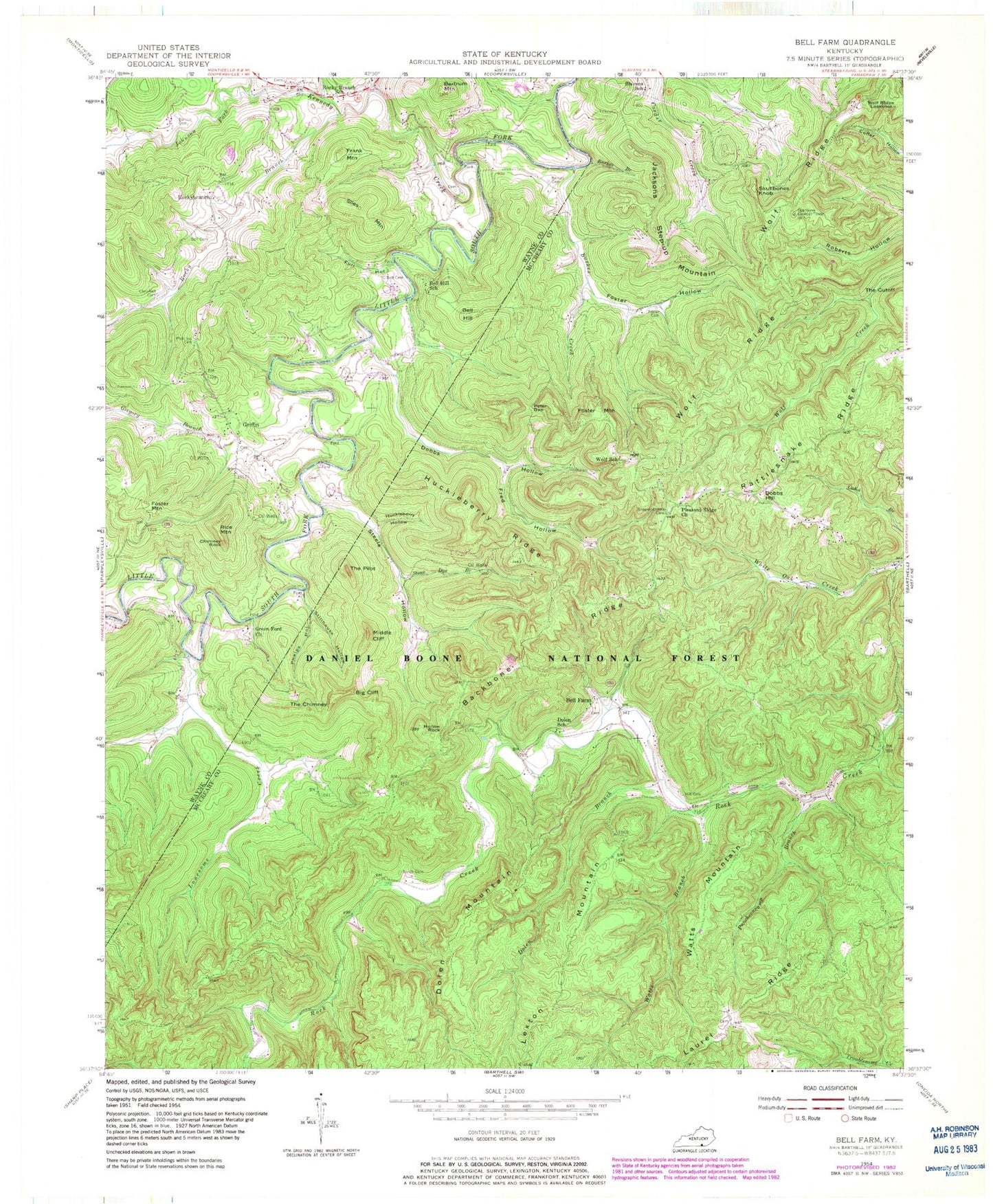
Classic USGS Bell Farm Kentucky 7.5'x7.5' Topo Map
Couldn't load pickup availability
Historical USGS topographic quad map of Bell Farm in the state of Kentucky. Map scale may vary for some years, but is generally around 1:24,000. Print size is approximately 24" x 27"
This quadrangle is in the following counties: McCreary, Wayne.
The map contains contour lines, roads, rivers, towns, and lakes. Printed on high-quality waterproof paper with UV fade-resistant inks, and shipped rolled.
Contains the following named places: Anderson Cemetery, Backbone Ridge, Barrier Cemetery, Barrier Cemetery Number 2, Bawley Ford, Bell Cemetery, Bell Farm, Bell Farm Horse Camp, Bell Farm Post Office, Bell Hill, Bell Hill School, Bertram Mountain, Big Cliff, Burke-Kidd Cemetery, Burkes Branch, Burkes Cemetery, Burkes Creek, Carl Kidd Graveyard, Chimney Rock, Co-operative Division, Co-operative Post Office, Criswell Cemetery, David L Crownshed Grave, Deer Loop, Denney Ford, Denney Pumping Station, Denny Farm Cemetery, Dobbs Hill, Dobbs Hollow, Dobbs School, Dolen Branch, Dolen Mountain, Dolen School, Foster Cemetery, Foster Hollow, Foster Mountain, Frank Mountain, Fred Hollow, Full Hollow, Grant Roberts Cemetery, Great Meadow Campground, Green Ford, Green Ford Church, Gregory Branch, Gregory Cemetery, Gregory Post Office, Griffin, Griffin Cemetery, Griffin Oil Pool, Griffin Post Office, Griffin School Number 2, Hemlock Grove Camping Area, Hemlock Grove Picnic Area, Hill Cemetery, Hollow Rock, Huckleberry Hollow, Huckleberry Ridge, Jacksons Step-up Mountain, John Barrier Cemetery, Johnson Fork, Kennedy Creek, Lexton Mountain, Lonesome Creek, Lonesome Ford, Lonesome Valley, Middle Cliff, Peter Gap, Phelps Hollow, Phillips Cemetery, Pleasant Ridge Church, Puncheoncamp Branch, Racoon Loop, Rattlesnake Ridge, Rice Mountain, Rigney-Gregory Cemetery, Rocky Branch, Rocky Branch School, Rockybranch, Rockybranch Post Office, Ryan Cemetery, Shearer- Dobbs Cemetery, Siles Mountain, Skullbone Lookout Tower, Skullbones Knob, Slavans School, Smith Cemetery, Steele Cemetery, Steele Ford, Steele Hollow, Steele Old Mill, Stillhouse Hollow, Stone Dye Branch, The Caylor Cemetery, The Chimney, The Cutoff, The Denny Hollow, The Frank Spring, The Mill Cliff, The Pilot, Turkey Branch, Watts Branch, Watts Mountain, Wolf Ridge, Wolf Ridge Lookover, Wolf School, ZIP Code: 42647