MyTopo
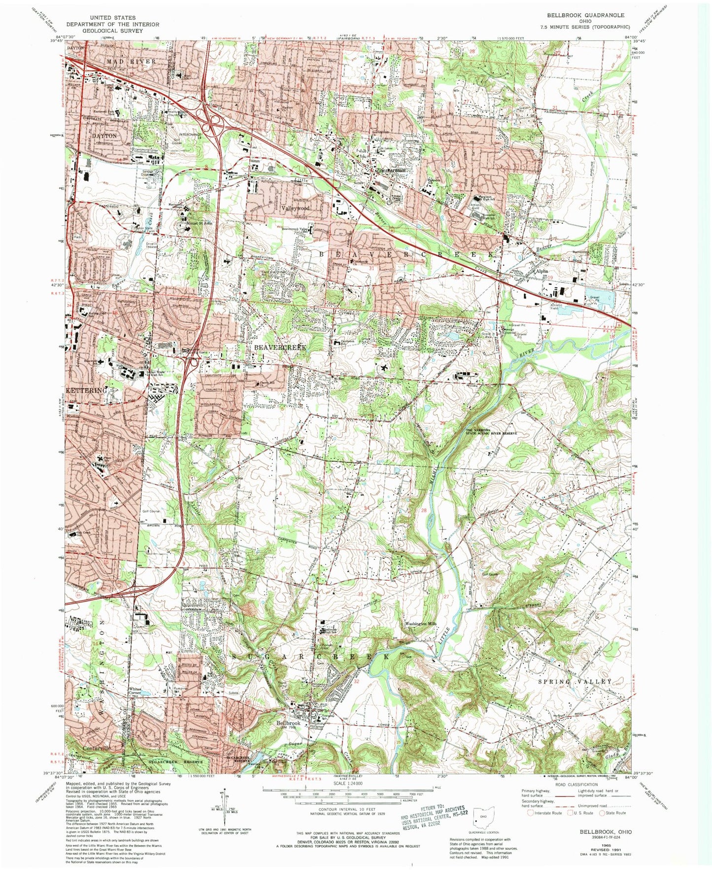
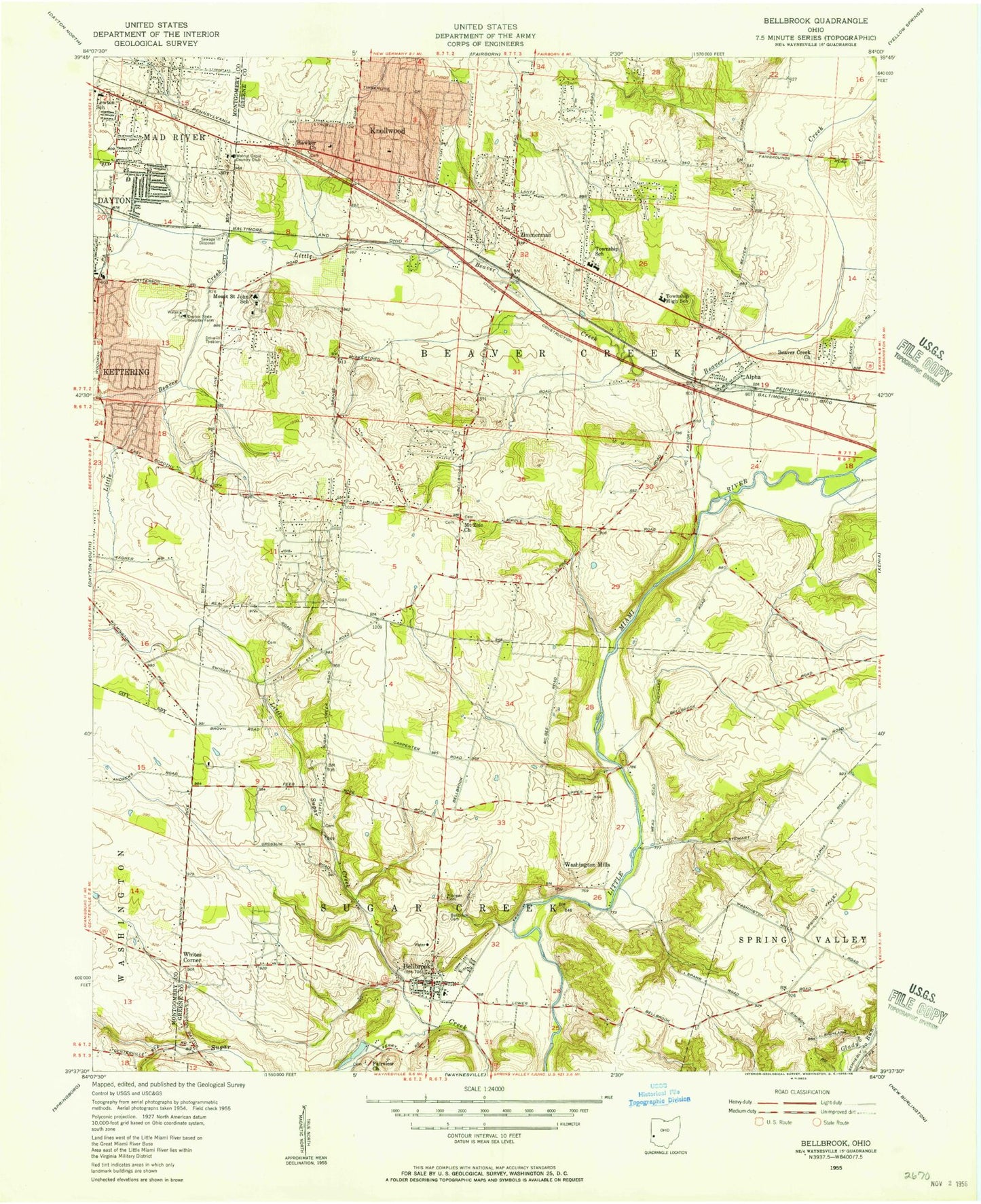
Classic USGS Bellbrook Ohio 7.5'x7.5' Topo Map
Couldn't load pickup availability
Historical USGS topographic quad map of Bellbrook in the state of Ohio. Typical map scale is 1:24,000, but may vary for certain years, if available. Print size: 24" x 27"
This quadrangle is in the following counties: Greene, Montgomery.
The map contains contour lines, roads, rivers, towns, and lakes. Printed on high-quality waterproof paper with UV fade-resistant inks, and shipped rolled.
Contains the following named places: Beaver Creek, Beavercreek Church, Beavercreek Church, Bellbrook High School, Carroll High School, Cherry Hill Church, Crestview Nursing Home, Dayton State Hospital Farm, Fairview Church, Furgerson Junior High School, Hawker Church, Indian Riffle Park, Little Beaver Creek, Little Sugar Creek, Oak Creek School, Pioneer Cemetery, Rolling Field School, Rosewood School, Saint Lukes School, West School, Beavercreek, Mount Saint John, Valleywood, Sugarvalley Country Club, Parkwood Elementary School, Charles I Beaver Park, Shoup Park, Beavercreek Plaza Shopping Center, Merrick Park, School Number 1 (historical), Mount Zion Park Cemetery, Mount Zion Shoup Cemetery, School Number 4 (historical), Clemmer School (historical), Sugarcreek Education Center, Sugarcreek Elementary School, Miami Valley Research Park, Cinnamon Creek Park, Indian Riffle Shopping Center, Herman K Ankeney Junior High School, School Number 1 (historical), Whites School (historical), Spring Lake Park, Lantz School (historical), Beavercreek High School, Rotary Park, The Narrows State Scenic River Reserve, Farther School (historical), Virgillato Park, Indian Riffle Junior High School, Mount Zion Church, Beaver Valley Shopping Center, Knollwood Shopping Center, Pelbrook Community Shopping Center, Sugarcreek Reserve, Alpha, East Dayton Baptist Church, Lebanon Junction, Kettering Junior High School, School Number 1 (historical), Oak Creek Park, Wilmington Heights Shopping Center, Beavercreek Valley School, Zimmerman, Black Oak East Park, Cloverbrook Park, Pondview Park, Park Layne Park, Will Grove Golf Club, Clement, Washington Mills, Whites Corner, Marianists College, Rollandia Golf Course, Dayton Sugarcreek Office Park, Bellbrook, Knollwood, Eastmont Freewill Baptist Church, Eastmont United Methodist Church, Spaulding Road Church of God, Huffman Dam, Huffman Reservoir, Walnut Grove Country Club, Stephen Bell Elementary School, Eastmont Elementary School for Environmental Science, Fairbrook Elementary School, Lewton Elementary School, J E Prass Elementary School, Plasco Field Heliport, Claypool Heliport, Woodlane Plaza Shopping Center, Township of Beavercreek, Birchwood Club, Morgan Cemetery (historical), Beaver Cemetery, Bellbrook Cemetery, Fallis Cemetery, Hawker Cemetery, Hering Cemetery, McLane / McLean-Huston Cemetery, Fairview Primitive Baptist Church Cemetery, Schmidt Cemetery, Alpha Post Office, Bellbrook Post Office, Zimmerman Post Office (historical), City of Beavercreek, City of Bellbrook, Sweet Arrow Farm, Kettering Fire Department Station 34, Beavercreek Township Fire Department Station 62, Sugarcreek Township Fire Department and Emergency Medical Services - Station 1, Beavercreek Township Fire Department Station 61, Beavercreek Township Fire Department Station 64, Bellbrook Fire Department Station 2, Sugarcreek Township Fire Department - Station 2, Bellbrook Fire Dept Station 1, Riverside Fire Department Station 6, Captain Nathan Lammes Creek, Beavercreek Police Department, Bellbrook Police Department, Sugarcreek Township Police Department, Miami Valley Hospital South, Beavercreek Post Office, Huston Cemetery