

MyTopo
Classic USGS Belvidere New Jersey 7.5'x7.5' Topo Map
Couldn't load pickup availability
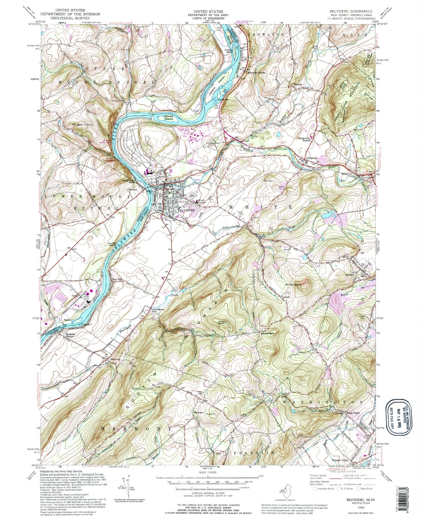
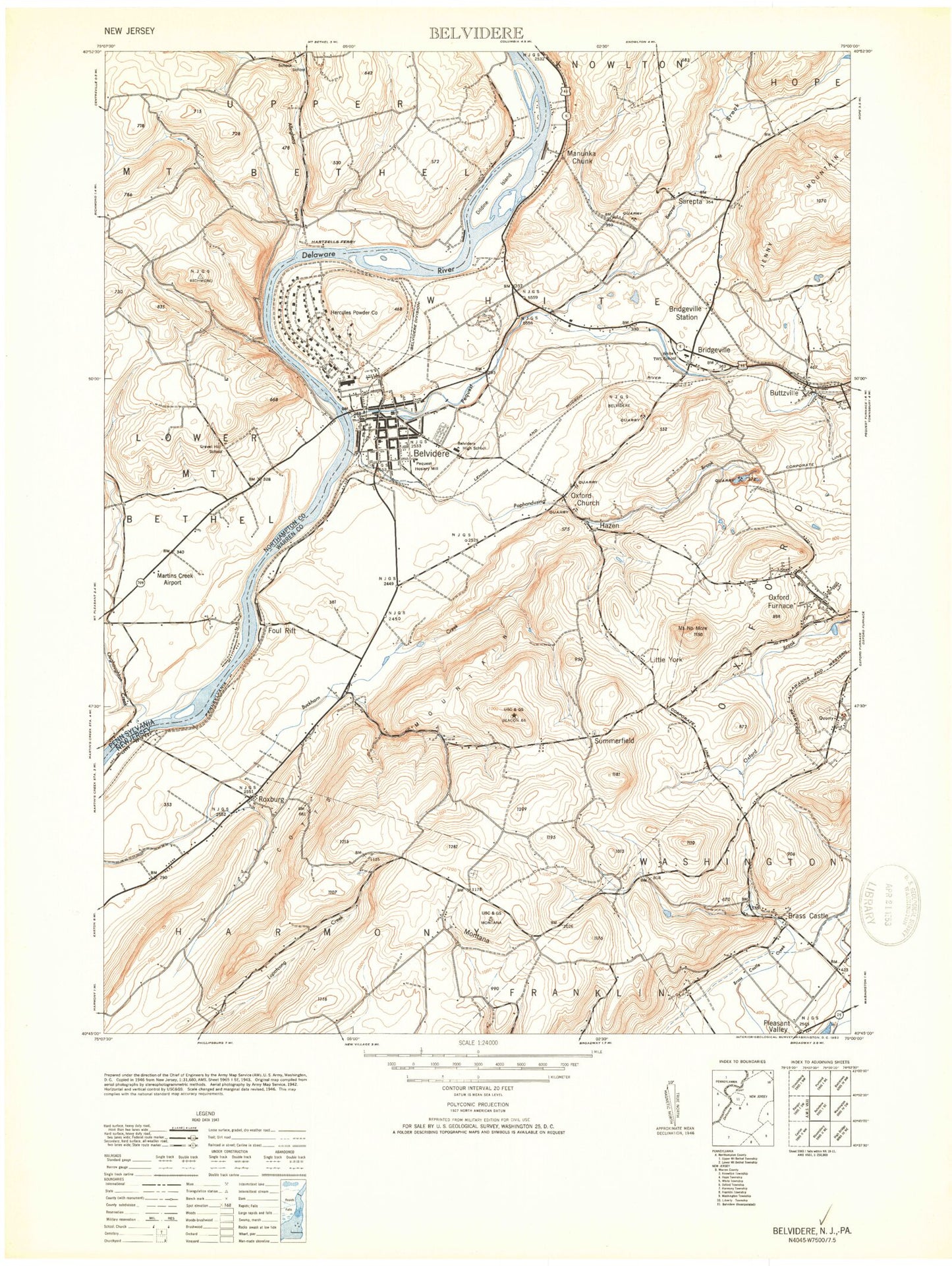
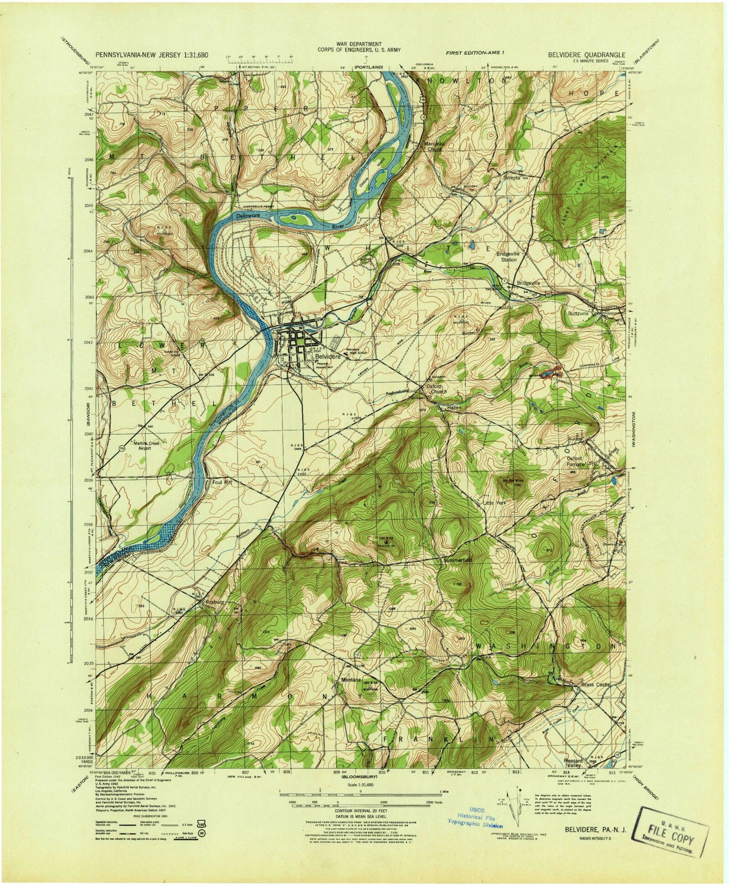
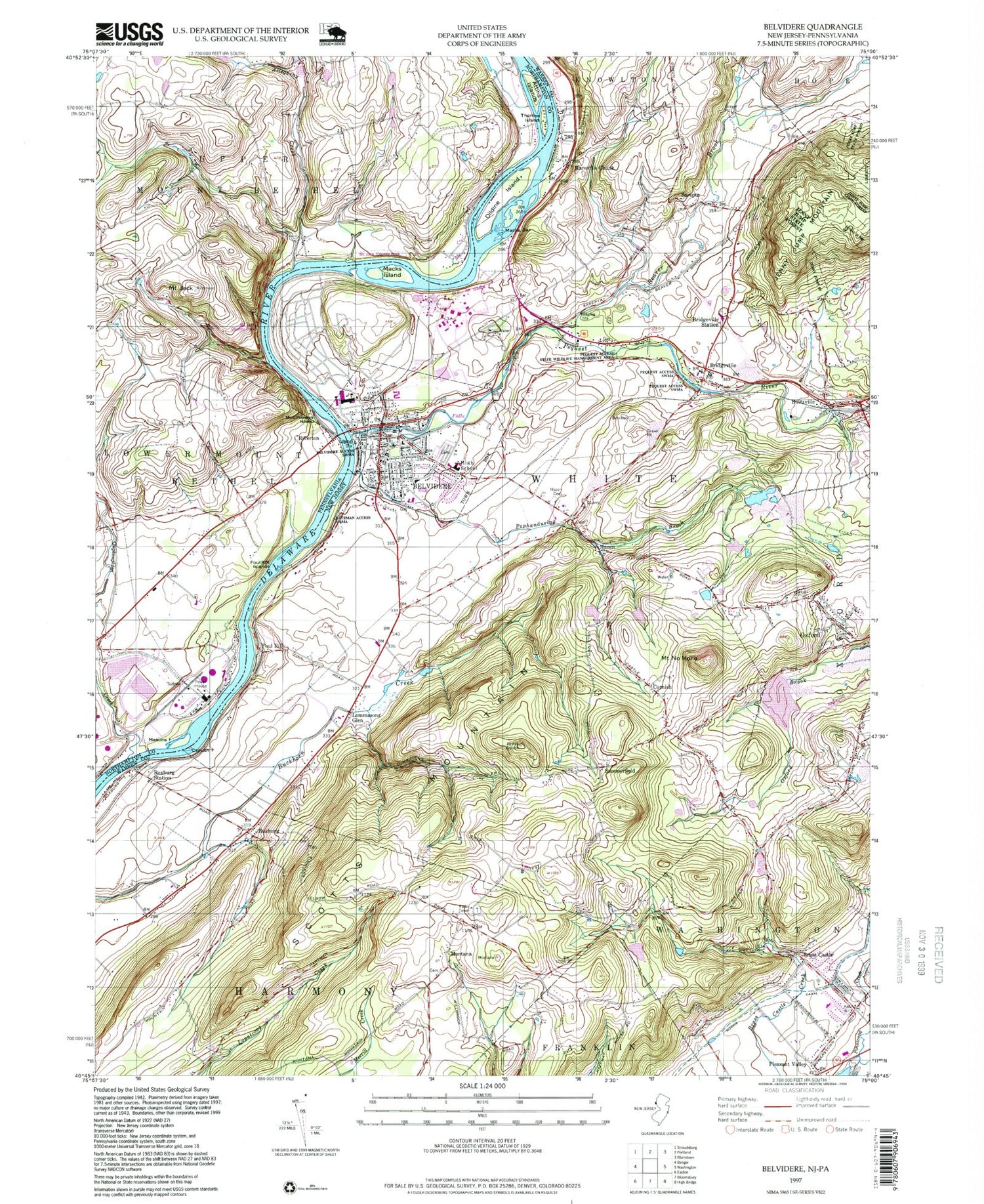
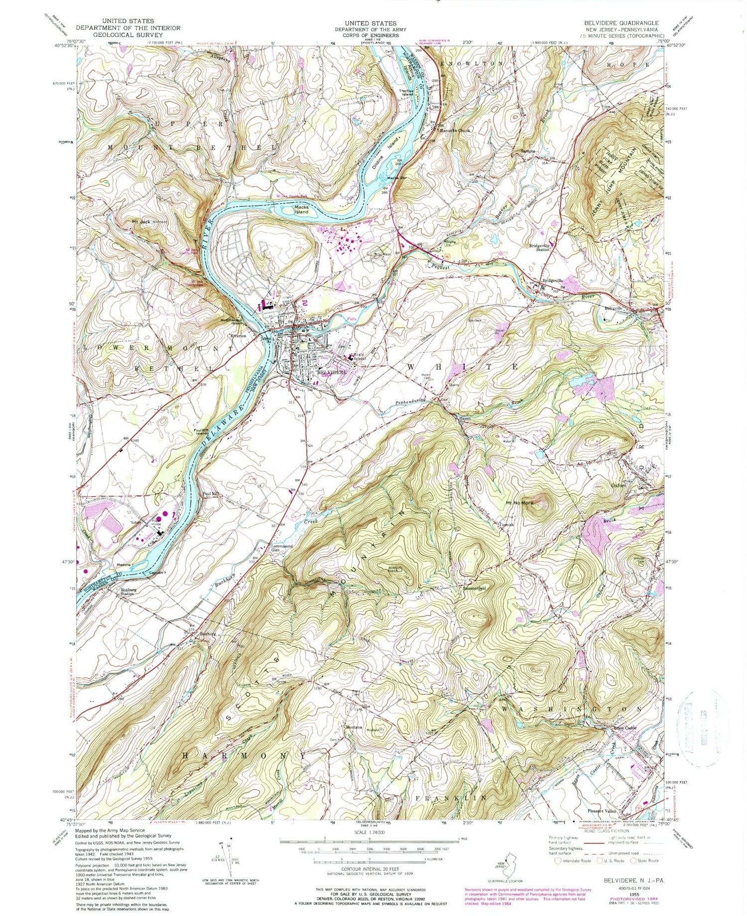
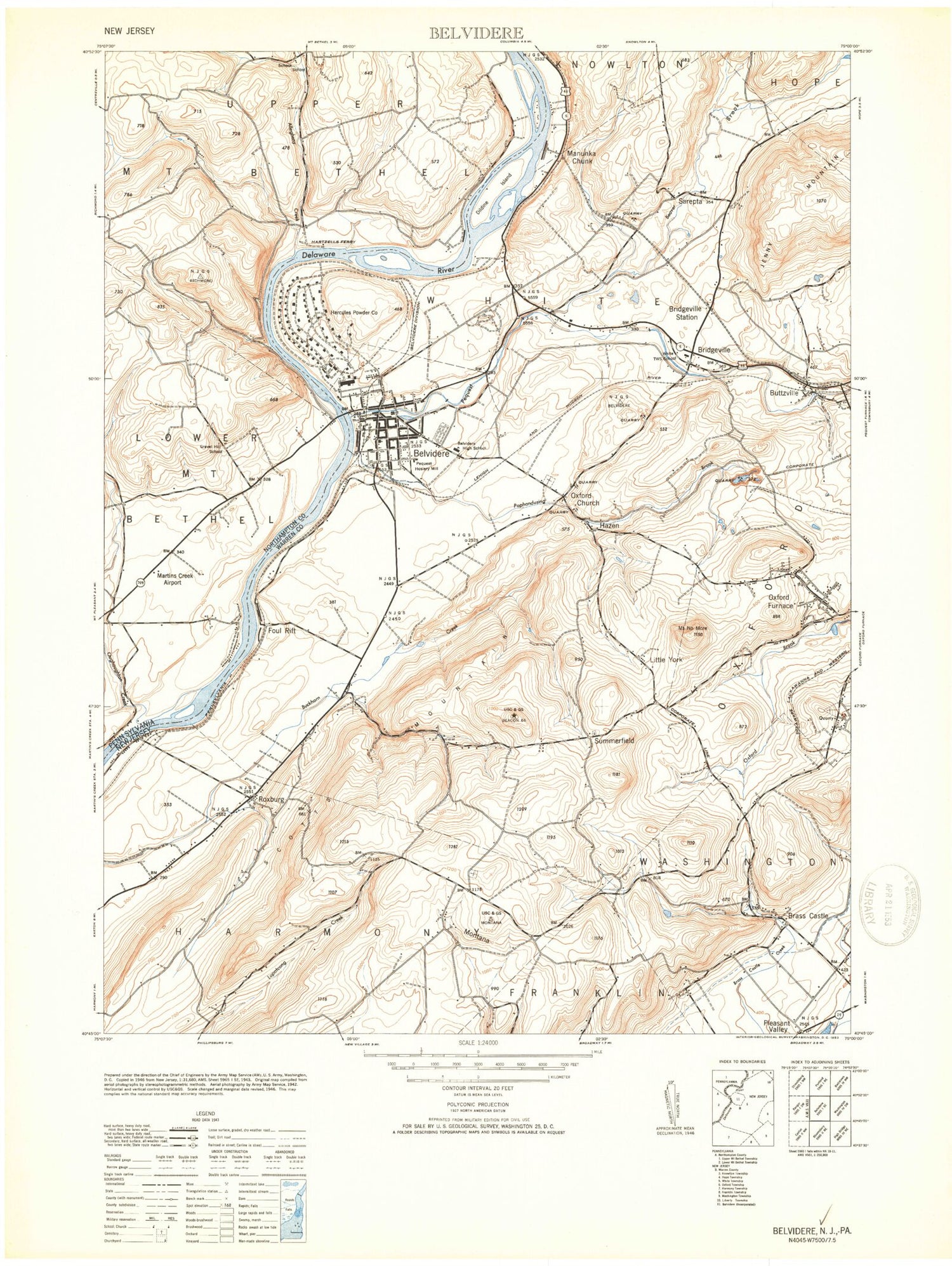
Historical USGS topographic quad map of Belvidere in the states of New Jersey, Pennsylvania. Typical map scale is 1:24,000, but may vary for certain years, if available. Print size: 24" x 27"
This quadrangle is in the following counties: Northampton, Warren.
The map contains contour lines, roads, rivers, towns, and lakes. Printed on high-quality waterproof paper with UV fade-resistant inks, and shipped rolled.
Contains the following named places: Beaver Brook, Belvidere, Brass Castle, Bridgeville, Bridgeville Station, Buttzville, Capush Island, Cornish, Dildine Island, Foul Rift, Foul Rift Islands, Hazen, Hazen Cemetery, Hillside Cemetery, Lommasons Glen, Macks Bar, Macks Island, Manunka Chunk, Montana, Mount No More, Pequest River, Pleasant Valley, Pophandusing Brook, Roxburg Station, Roxburg, Sarepta, Summerfield, Township of White, Township of Harmony, Foul Rift Falls, Angens Pond Dam, Angens Pond, Matthews Airport, Johnson Farms Airport (historical), Town of Belvidere, White Township School, Brass Castle Elementary School, Brass Castle Census Designated Place, Mackeys Orchard, Matarazzo Farms, Stoneyfield Orchards, Oxford Quarry, Bridgeville Census Designated Place, Brookfield Census Designated Place, Buttzville Census Designated Place, Hutchinson Census Designated Place, Good Will Fire Company Station 1, DSM Industrial Products Fire and Rescue Brigade, Washington Township Volunteer Fire Department, Belvidere Volunteer Ambulance Corps, DSM Emergency Medical Services, Warren County Sheriff's Office - Police Office, Belvidere Police Department, Warren County Correctional Center, Belvidere Post Office, Allegheny Creek, Attins Islands, Mount Jack, Masons Island, McElhaneys Island, Oughoughton Creek, Thomas Island, Schoch School, Belvidere Corner School, Hartzells Ferry (historical), Mount Jack County Park, Ott Hill, Gravel Hill School (historical), Foul Rift, Mill Creek, Riverton, Belvidere Ferry (historical), Foul Rift Ferry, Hartzells Ferry, Martins Creek Airport (historical), Beaver Brook, Belvidere, Brass Castle, Bridgeville, Bridgeville Station, Buttzville, Capush Island, Cornish, Dildine Island, Foul Rift, Foul Rift Islands, Hazen, Hazen Cemetery, Hillside Cemetery, Lommasons Glen, Macks Bar, Macks Island, Manunka Chunk, Montana, Mount No More, Pequest River, Pleasant Valley, Pophandusing Brook, Roxburg Station, Roxburg, Sarepta, Summerfield, Township of White, Township of Harmony, Foul Rift Falls, Angens Pond Dam, Angens Pond, Matthews Airport, Johnson Farms Airport (historical), Town of Belvidere, White Township School, Brass Castle Elementary School, Brass Castle Census Designated Place, Mackeys Orchard, Matarazzo Farms, Stoneyfield Orchards, Oxford Quarry, Bridgeville Census Designated Place, Brookfield Census Designated Place, Buttzville Census Designated Place, Hutchinson Census Designated Place, Good Will Fire Company Station 1, DSM Industrial Products Fire and Rescue Brigade, Washington Township Volunteer Fire Department, Belvidere Volunteer Ambulance Corps, DSM Emergency Medical Services, Warren County Sheriff's Office - Police Office, Belvidere Police Department, Warren County Correctional Center, Belvidere Post Office, Allegheny Creek, Attins Islands, Mount Jack, Masons Island, McElhaneys Island, Oughoughton Creek, Thomas Island, Schoch School, Belvidere Corner School, Hartzells Ferry (historical), Mount Jack County Park, Ott Hill, Gravel Hill School (historical), Foul Rift, Mill Creek, Riverton, Belvidere Ferry (historical), Foul Rift Ferry, Hartzells Ferry, Martins Creek Airport (historical), Beaver Brook, Belvidere, Brass Castle, Bridgeville, Bridgeville Station, Buttzville, Capush Island, Cornish, Dildine Island, Foul Rift, Foul Rift Islands, Hazen, Hazen Cemetery, Hillside Cemetery, Lommasons Glen, Macks Bar, Macks Island, Manunka Chunk, Montana, Mount No More, Pequest River, Pleasant Valley, Pophandusing Brook, Roxburg Station, Roxburg, Sarepta, Summerfield, Township of White, Township of Harmony, Foul Rift Falls, Angens Pond Dam, Angens Pond, Matthews Airport, Johnson Farms Airport (historical), Town of Belvidere, White Township School, Brass Castle Elementary School, Brass Castle Census Designated Place, Mackeys Orchard, Matarazzo Farms, Stoneyfield Orchards, Oxford Quarry, Bridgeville Census Designated Place, Brookfield Census Designated Place, Buttzville Census Designated Place, Hutchinson Census Designated Place, Good Will Fire Company Station 1, DSM Industrial Products Fire and Rescue Brigade, Washington Township Volunteer Fire Department, Belvidere Volunteer Ambulance Corps, DSM Emergency Medical Services, Warren County Sheriff's Office - Police Office, Belvidere Police Department, Warren County Correctional Center, Belvidere Post Office, Allegheny Creek, Attins Islands, Mount Jack, Masons Island, McElhaneys Island, Oughoughton Creek, Thomas Island, Schoch School, Belvidere Corner School, Hartzells Ferry (historical), Mount Jack County Park, Ott Hill, Gravel Hill School (historical), Foul Rift, Mill Creek, Riverton, Belvidere Ferry (historical), Foul Rift Ferry, Hartzells Ferry, Martins Creek Airport (historical), Beaver Brook, Belvidere, Brass Castle, Bridgeville, Bridgeville Station, Buttzville, Capush Island, Cornish, Dildine Island, Foul Rift, Foul Rift Islands