
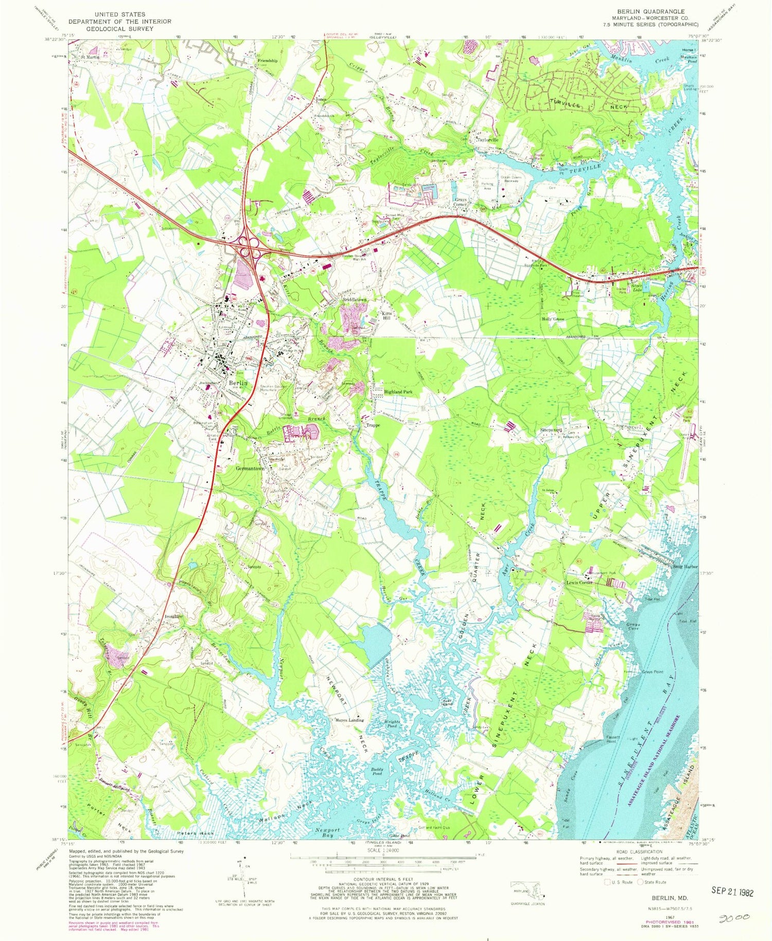
MyTopo
Classic USGS Berlin Maryland 7.5'x7.5' Topo Map
Couldn't load pickup availability
Historical USGS topographic quad map of Berlin in the state of Maryland. Map scale is 1:24000. Print size is approximately 24" x 27"
This quadrangle is in the following counties: Worcester.
The map contains contour lines, roads, rivers, towns, and lakes. Printed on high-quality waterproof paper with UV fade-resistant inks, and shipped rolled.
Contains the following named places: Albatross Mobile Home Park, Ames Shopping Center, Atlantic General Hospital, Ayer Creek, Ayer Island, Bassett Mill (historical), Bassett Millpond, Bat Creek, Battle Branch, Beach Club Golf Links, Beary Best Day Care Center, Beaverdam Creek, Berlin, Berlin Baptist Church, Berlin Branch Library, Berlin Commercial Historic District, Berlin Fire Company 2 Station 2, Berlin High School (historical), Berlin Intermediate School, Berlin Nursing Home, Berlin Police Department, Berlin Post Office, Berlin Run Shopping Center, Berlin Shopping Center, Berlin Town Hall, Berlin Volunteer Fire Company - Station 600, Berlin Wastewater Treatment Plant, Bethany Cemetery, Bethany Church, Briddletown, Buckingham Academy (historical), Buckingham Elementary School, Buckingham Presbyterian Cemetery, Buckingham Presbyterian Church, Buddy Pond, Bunting's Field, Carey Marina, Church of God of Prophecy, Cotton Hill Camp, Crippen Branch, Deals Branch, Dills Acres, Douglynne Woods, Dutch Harbor, Eagles Landing Golf Course, Evergreen Cemetery, Fassett Point, First Baptist Church, Flower Street School, Franklin Heights, Friendship, Friendship Church, Friendship Estates, Frontier Amusement Park, Gambage Island, Germantown, Golden Quarter Neck, Golf Club Shores, Goody Hill Branch, Grays Corner, Grays Cove, Grays Creek, Grays Point, Greys Inlet, Gull Creek Senior Living Community, Gum Point, Hayes Landing, Herring Creek, Herring Gut, Highland Park, Holland Creek, Holly Grove, Hollygrove Swamp, Horse Island, Hudson Branch, Ironshire, Jake Gut, Jenkins Creek, Jones, Kitts Branch, Kitts Hill, Lake Haven Mobile Home Park, Lewis Corner, Manklin Creek, Maryland State Police - Barrack V Berlin, Moccasin Pond, Morris Mobile Home Park, Mud Creek, New Bethel Church, Newbay Ferry (historical), Newport Creek, Newport Hills, Newport Neck, Ocean City Golf and Yacht Club, Ocean Downs Raceway, Ocean Resorts Golf Club, Orchard Creek, Pomona Heights, Poplartown Branch, Porter Neck, Saint Johns Church, Saint Johns United Methodist Church, Saint Martin, Saint Pauls Church, Saint Pauls Episcopal Church, Saint Pauls Episcopal Church Cemetery, Salt Grass Cove, Sandy Cove, Sherwood Forest, Silver Lake Mobile Home Park, Sinepuxent, Sinepuxent Bay, Sinepuxent Neck, Snug Harbor, Snug Harbor, Stephen Decatur High School, Stephen Decatur Middle School, Stephen Decatur Monument, Stevenson United Methodist Church, Sunset Memorial Park, Taylorville, Taylorville Creek, Taylorville United Methodist Church, Town of Berlin, Trappe, Trappe Creek, Trappe Mill Pond (historical), Tukesbury Branch, Turville Neck, Tyree Cemetery, Tyree Church, Wallops Neck, WKHI-FM (Ocean City), Wood Duck Isle, Worcester County Vocational-Technical School, Worcester Preparatory School, Wrights Pond


