MyTopo
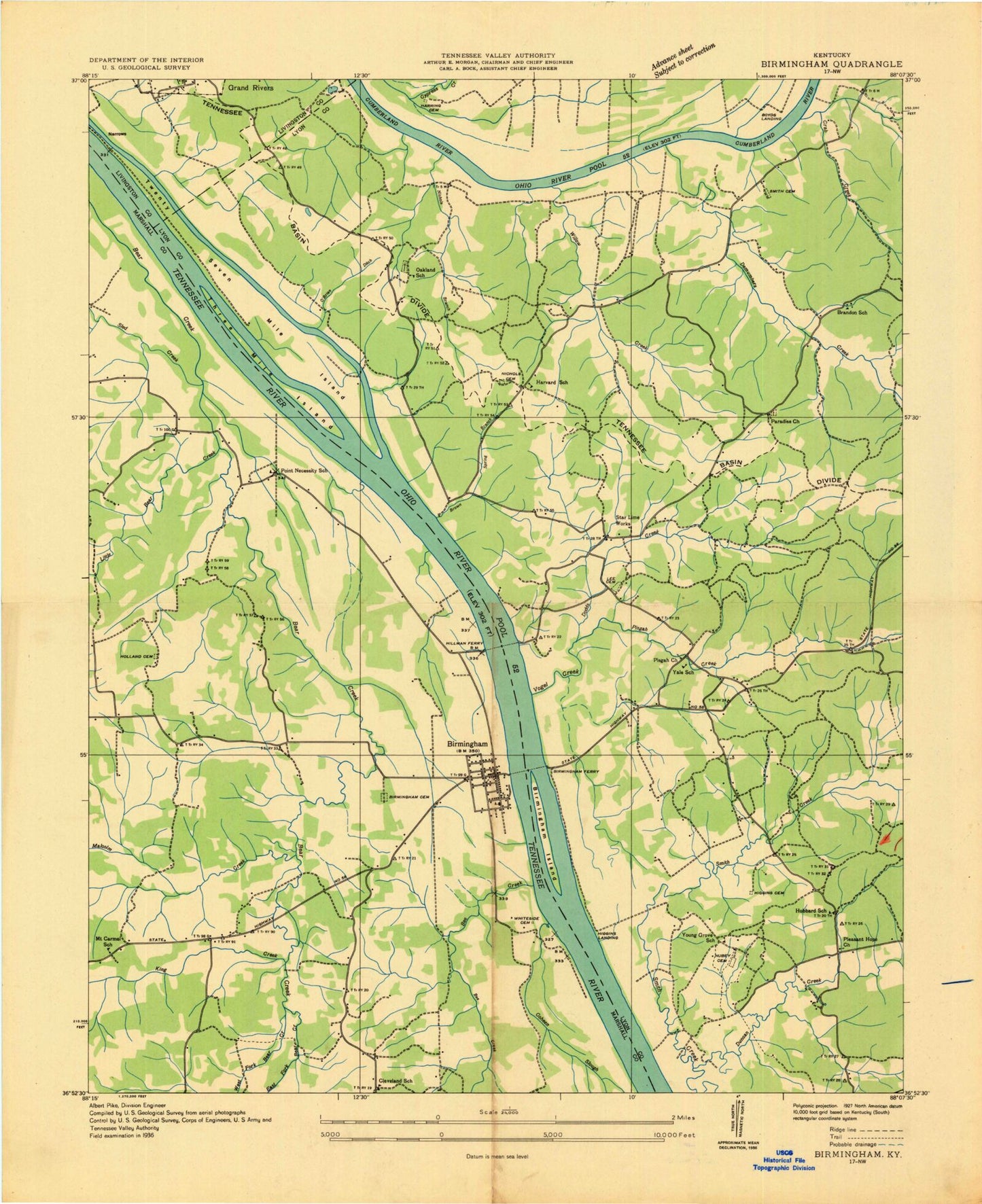
Classic USGS Birmingham Point Kentucky 7.5'x7.5' Topo Map
Couldn't load pickup availability
Historical USGS topographic quad map of Birmingham Point in the state of Kentucky. Typical map scale is 1:24,000, but may vary for certain years, if available. Print size: 24" x 27"
This quadrangle is in the following counties: Livingston, Lyon, Marshall, Trigg.
The map contains contour lines, roads, rivers, towns, and lakes. Printed on high-quality waterproof paper with UV fade-resistant inks, and shipped rolled.
Contains the following named places: Barkley Canal, Barnett Cemetery, Bear Creek, Bee Spring Camp, Big Bear Camp, Big Bear Creek, Birmingham, Birmingham Ferry Recreation Area, Birmingham Point, Brown Spring, Buckhorn Creek, Cambridge Shores, Camp Cum-Ba-Ya, Camp Currie, Canal Public Use Area, Cap Spring Creek, Crab Bay, Crab Creek, Demumbers Bay, Demumbers Creek, Demumbers Point Recreation Area, Dodds Creek, Isaac Gray Cemetery, Hillman Ferry Camping Area, King Creek, King Creek Camp, Little Bear Creek, Little Bear Creek, Malcolm Creek, Malcolm Creek Camp, Marshall, Moss Creek, Newby Cemetery, Nickell Branch, Nickell Cove, Nickell Point Recreation Area, O'Brien Branch, Paradise Church, Pisgah Bay, Pisgah Creek, Pisgah Point Recreation Area, Sherwood Shores, Smith Bay, Smith Creek, The Moors, Will-Vera Camp, Willow Bay, Willow Creek, Duncan Bay, Brien, Buena Vista, Twin Lakes, East Marshall Fire Department Station 1, East Marshall Fire Department Station 2, Grand Lakes Fire Department Station 1, Seven Mile Island (historical), Three Mile Island (historical), Governor Keen Johnson Historical Marker, Andrew Jackson Smith Historical Marker, Governor Keen Johnson Historical Marker, Birmingham Island Cemetery, Barkley Canal, Barnett Cemetery, Bear Creek, Bee Spring Camp, Big Bear Camp, Big Bear Creek, Birmingham, Birmingham Ferry Recreation Area, Birmingham Point, Brown Spring, Buckhorn Creek, Cambridge Shores, Camp Cum-Ba-Ya, Camp Currie, Canal Public Use Area, Cap Spring Creek, Crab Bay, Crab Creek, Demumbers Bay, Demumbers Creek, Demumbers Point Recreation Area, Dodds Creek, Isaac Gray Cemetery, Hillman Ferry Camping Area, King Creek, King Creek Camp, Little Bear Creek, Little Bear Creek, Malcolm Creek, Malcolm Creek Camp, Marshall, Moss Creek, Newby Cemetery, Nickell Branch, Nickell Cove, Nickell Point Recreation Area, O'Brien Branch, Paradise Church, Pisgah Bay, Pisgah Creek, Pisgah Point Recreation Area, Sherwood Shores, Smith Bay, Smith Creek, The Moors, Will-Vera Camp, Willow Bay, Willow Creek, Duncan Bay, Brien, Buena Vista, Twin Lakes, East Marshall Fire Department Station 1, East Marshall Fire Department Station 2, Grand Lakes Fire Department Station 1, Seven Mile Island (historical), Three Mile Island (historical), Governor Keen Johnson Historical Marker, Andrew Jackson Smith Historical Marker, Governor Keen Johnson Historical Marker, Birmingham Island Cemetery, Barkley Canal, Barnett Cemetery, Bear Creek, Bee Spring Camp, Big Bear Camp, Big Bear Creek, Birmingham, Birmingham Ferry Recreation Area, Birmingham Point, Brown Spring, Buckhorn Creek, Cambridge Shores, Camp Cum-Ba-Ya, Camp Currie, Canal Public Use Area, Cap Spring Creek, Crab Bay, Crab Creek, Demumbers Bay, Demumbers Creek, Demumbers Point Recreation Area, Dodds Creek, Isaac Gray Cemetery, Hillman Ferry Camping Area, King Creek, King Creek Camp, Little Bear Creek, Little Bear Creek, Malcolm Creek, Malcolm Creek Camp, Marshall, Moss Creek, Newby Cemetery, Nickell Branch, Nickell Cove, Nickell Point Recreation Area, O'Brien Branch, Paradise Church, Pisgah Bay, Pisgah Creek, Pisgah Point Recreation Area, Sherwood Shores, Smith Bay, Smith Creek, The Moors, Will-Vera Camp, Willow Bay, Willow Creek, Duncan Bay, Brien, Buena Vista, Twin Lakes, East Marshall Fire Department Station 1, East Marshall Fire Department Station 2, Grand Lakes Fire Department Station 1, Seven Mile Island (historical), Three Mile Island (historical), Governor Keen Johnson Historical Marker, Andrew Jackson Smith Historical Marker, Governor Keen Johnson Historical Marker, Birmingham Island Cemetery