MyTopo
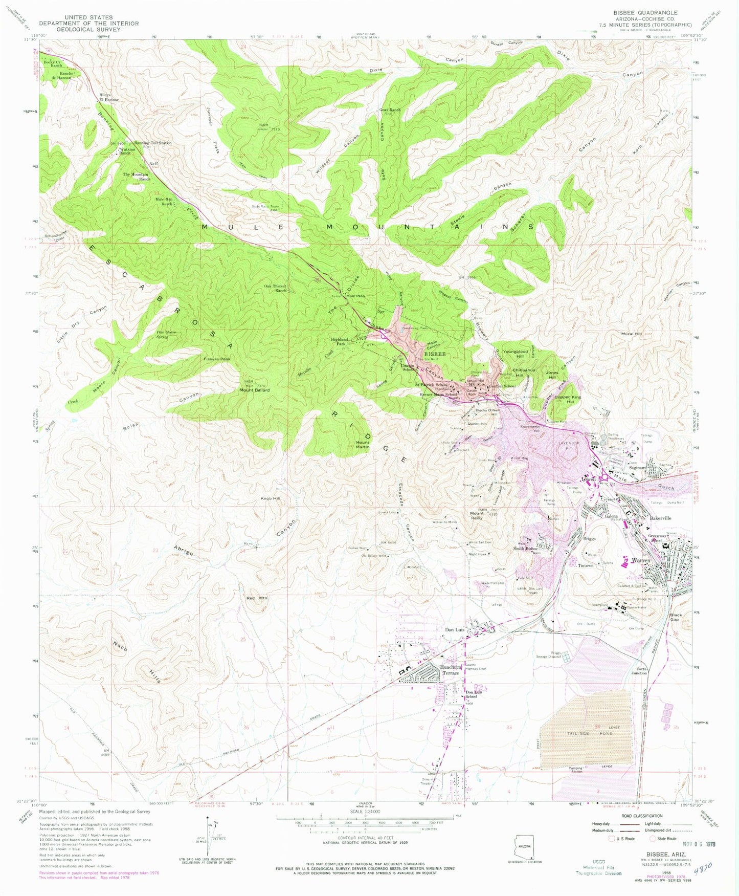
Classic USGS Bisbee Arizona 7.5'x7.5' Topo Map
Couldn't load pickup availability
Historical USGS topographic quad map of Bisbee in the state of Arizona. Typical map scale is 1:24,000, but may vary for certain years, if available. Print size: 24" x 27"
This quadrangle is in the following counties: Cochise.
The map contains contour lines, roads, rivers, towns, and lakes. Printed on high-quality waterproof paper with UV fade-resistant inks, and shipped rolled.
Contains the following named places: Abrigo Canyon, Bakerville, Mount Ballard, Banning Toll Station, Bisbee, Bisbee West, Black Gap, Bolsa Canyon, Boras Mine, Brewery Gulch, Briggs, Bucky O'Neill Hill, Calumet Mine, Campbell, Castle Rock, Central School, Chihuahua Hill, Cochise, Cole, Cole Number Three, Congdon, Contact, Copper King, Copper King Canyon, Copper King Hill, Copper Queen, Dallas, Dern Mine, Don Luis, Don Luis School, Dubacher Canyon, Durazo Canyon, Escabrosa Ridge, Escacado Canyon, Evergreen Cemetery, Fissure Peak, Galena, Galena, Goat Ranch, Greenway Elementary School, Hendricks Gulch, Highland Park, Hoatson, Horace Mann School, Huachuca Terrace, Irish Mag, Jones Hill, Juniper Flats, Knob Hill, Lincoln School, Little Dry Canyon, Lovers Leap, Lowell, Lucky Jack, Mount Martin, Moon Canyon, Moore Canyon, Morales Creek, Mule Mountain Ranch, Mule Pass, Mural Hill, Naco Hills, Night Hawk, Oak Thicket Ranch, Old Bisbee West, Pete Moore Spring, Powell, Quality Hill, Quarry Canyon, Queen Hill, Rancho de Hannon, Red Mountain, Mount Reilly, Rock Creek Ranch, Sacramento Hill, Saginaw, Saginaw, Saint Patrick School, Scherer Canyon, School Hill, Shattuck, Silver Bear, Silver Bear Gulch, South Bisbee, Spring Canyon, Steele Canyon, Sunrise, The Divide, The Mountain Ranch, Tintown, Tombstone Canyon, Uncle Sam, Uncle Sam Gulch, Wade Hampton Pit, Warren, Warren, Watkins Ranch, White Tail Deer, Wildcat Canyon, Wildcat Canyon, Wolverine Mines, Wood Canyon, Youngblood Hill, Art Hill, Bailey Hill, Bisbee City Hall, Bisbee High School, Bisbee Railroad Station, Cochise County Courthouse, Higgins Hill, Bisbee Middle School, Laundry Hill, Lavender Open Pit Mine, Lorta Railroad Station, Lowell Junior High School, Mason Hill, Miller Hill, Mule Pass Tunnel, Old Bisbee High School, Old City Park - Bisbee, Tank Hill, Wade Hampton Pit Mine, Warren Hill, Warren Railroad Station, Williams Hill, Corta Junction, Neff, Rileys El Encinar, Briggs Sewage Disposal, KBZB-AM (Bisbee), KZMK-FM (Bisbee), Bisbee Post Office, Bisbee Post Office, KBZB-AM (Bisbee), KBZB-AM (Bisbee), City of Bisbee, Phelps Dodge General Office Building, Ppep Tec High School Manuel Borjorquez Learning Center, Carmel Community Arts and Technology Charter School, Bisbee Fire Department Station 82, Copper Queen Post Office, Warren Post Office, Sieling's Mobile Village, Cooper Queen Community Hospital, Copper Queen Hospital Heliport, Bisbee Covenant Presbyterian Church, First Assembly of God, New Life Assembly of God Church, Saint John's Episcopal Church, San Jose Southern Baptist Church, Church of Christ, Church of the Nazarene, Community Church of Warren, First Southern Baptist Church, Grace Lutheran Church, Hope Lutheran Church, Saint Patrick Catholic Church, Saint Stephen Nemanja Church, The Church of Jesus Christ of Latter Day Saints, Trinity United Methodist Church, Bisbee Mining and Historical Museum, Bisbee Fire Station 81, Copper Queen Community Hospital, Bisbee Police Department