

MyTopo
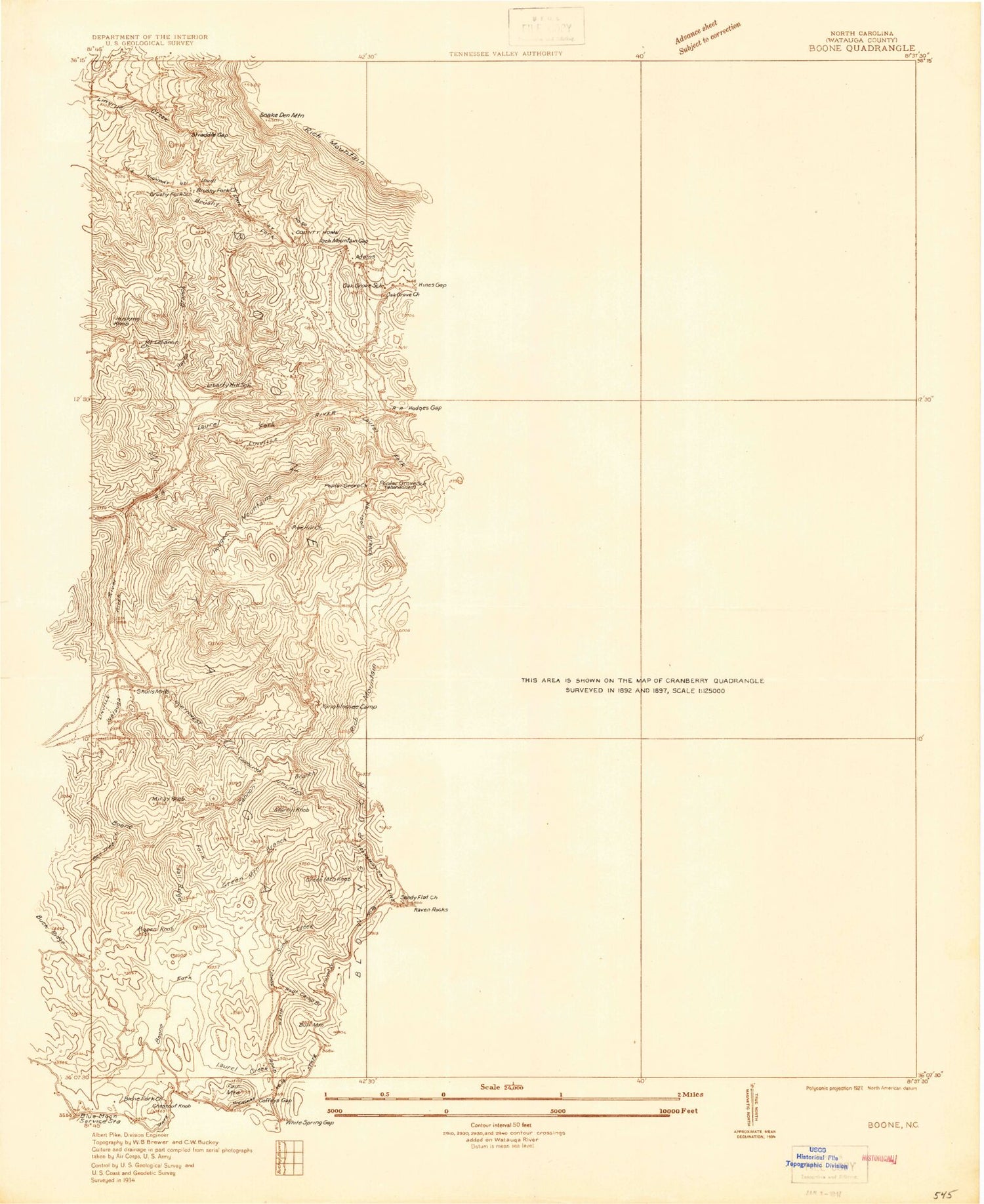
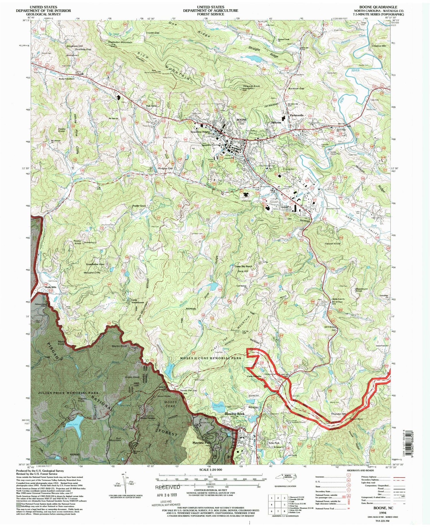
USGS Classic Boone North Carolina 7.5'x7.5' Topo Map
Couldn't load pickup availability
Historical USGS topographic quad map of Boone in the state of North Carolina. Scale: 1:24000. Print size: 24" x 27"
This quadrangle is in the following counties: Watauga.
The map contains contour lines, roads, rivers, towns, lakes, and grids including latitude / longitude and UTM / MGRS. Printed on high-quality waterproof paper with UV fade-resistant inks.
Contains the following named places: Brown Branch, Chetola Lake, Price Lake, Snakeden Mountain, Trout Lake, Ski Mountain, Watauga County, Adams Cemetery, Aho Branch, Appalachian State University, Baldwin Cemetery, Barnes Cemetery, Bee Tree Creek, Big Branch, Blowing Rock, Boone, Boone Creek, Boone Fork, Brown Branch, Brown Cemetery, Broyhill Park, Brushy Fork Baptist Church, Buckeye Gap, Camp Catawba, Camp Sky Ranch, Camp Yonahlossee, Cannon Branch, Cold Prong, Cone Cemetery, Cook Cemetery, Cool Springs Cemetery, Cool Springs Baptist Church, Craig Cemetery, Daniel Boone Theater, Doe Fork, Doe Ridge, East Fork South Fork New River, Edmisten Cemetery, Edmisten Cemetery, Elrod Cemetery, Flannery Fork, Flat Top Branch, Flat Top Mountain, Friendship Church, Frye Cemetery, Goldmine Branch, Gragg Cemetery, Gragg Cemetery, Grandfather View, Grandview Heights, Green Branch, Green Cemetery, Greenway Baptist Church, Greer Cemetery, Groundhop Branch, Happy Valley, Harrison Branch, Hartley Cemetery, Hayes Branch, Hayes Cemetery, Hebron Colony Church, Hodges Creek, Hodges Gap, Hollars Cemetery, Hoot Camp Branch, Horse Branch, Horse Ridge, Horton Cemetery, Howard Creek, Howards Creek Baptist Church, Howard Knob, Julian Price Memorial Park, Lance Creek, Laurel Creek, Laurel Fork, Laurel Fork Baptist Church, Lovill, Middle Fork Baptist Church, Middle Fork South Fork New River, Miller Cemetery, Moore Cemetery, Moretz Cemetery, Moses H Cone Memorial Park, Mount Bethel Church, Mount Lawn Cemetery, Mount Lebanon Baptist Church, Mountain View Baptist Church, Mutton Creek, Norris Branch, Payne Branch, Penley Branch, Perkinsville, Pine Ridge, Piny Grove Cemetery, Pitts Cemetery, Pitts Cemetery, Prison Camp 116, Rich Mountain, Rocky Branch, Sandy Flats Baptist Church, Sandy Flat Gap, Sauls Camp Ridge, Coffey Cemetery, Sims Creek, Sims Pond, Straddle Gap, Straight Ridge, Sumpter Cabin Creek, Three Forks Baptist Church, Trivett Gap, Upper Laurel Fork, Vannoy Cemetery, White Cemetery, White Pine Cliffs, Williams Cemetery, Wilson Ridge, Winkler Cemetery, Winkler Creek, Woodlawn Cemetery, Boone Inc Airport, Chetola Lake Dam, Julian Price Lake Dam, Bass Lake, Cone Lake Dam, Sims Pond, Old Blowing Rock Water Supply Dam, Heart Lake Dam, Heart Lake, Trout Lake Dam, Appalachian Ski Mountain Dam, Appalachian Ski Mountain Lake, Boone Water Supply Dam, A S U Lake, A S U Dam, Adams, Blowing Rock City Park, Blowing Rock Elementary School, Boone Park, Hardin Park Elementary School, Hounds Ear, Howards Knob County Park, Junaluska City Park, Sorrento Skies, Watauga County High School, Watauga County Industrial Fields Complex, Watauga Village Shopping Center, Conrad Stadium, Dougherty Heights, New River Heights, Blairmont, Caldwell Community College, Baird Mountain, Boone Heights Shopping Center, Boone Mall, Southgate Shopping Center, Boone Golf Course, Meat Camp, Hayes Cemetery, WASU-FM (Boone), WOIX-AM (Blowing Rock), WATA-AM (Boone), Ansley Heights, Bingham Hill, Blackburn Knob, Bull Mountain, Buzzard Cliffs, Deck Hill, Echo Park, Green Knob, Hillcrest, Husky Knob, Martin Knob, Mayview Park, Myria Knob, Oak Grove, Pigpen Knob, Poplar Grove, Raven Rock, Raven Rocks, Rich Mountain, Rocky Knob, Shulls Mill, Thunder Hill, Yarnall Knob, Boone Lookout Tower, Township of Blowing Rock, Township of Boone, Township of Brushy Fork, Township of New River, Blowing Rock High School, Grave Yard (historical), Hodges Gap, Howard Creek School (historical), Liberty School (historical), Oak Grove Baptist Church, Poplar Grove Baptist Church, Shulls Mills Baptist Church, Town of Blowing Rock, Town of Boone, Shull Cemetery, Boone Fire Department Station 2, Blowing Rock Volunteer Fire Department, Boone Fire Department Headquarters, Bamboo Quarry, Hodges Gap Quarry, Watauga Medical Center, Blowing Rock Hospital, Blowing Rock Volunteer Rescue Squad Ambulance Service, Watauga Medics Ambulance Service, Watauga County Rescue Squad Ambulance Service, Downtown Boone Post Office, Blowing Rock Police Department, Boone Police Department, Watauga County Sheriff's Office, Blowing Rock Post Office, Boone Post Office, Middle Fork Baptist Church Cemetery, Boone Cemetery


